| |||||||||||||||||||||||||||||||||||||||||||||||||||||||||||||||||||||
| |||||||||||||||||||||||||||||||||||||||||||||||||||||||||||||||||||||
| |||||||||||||||||||||||||||||||||||||||||||||||||||||||||||||||||||||
| |||||||||||||||||||||||||||||||||||||||||||||||||||||||||||||||||||||
| |||||||||||||||||||||||||||||||||||||||||||||||||||||||||||||||||||||
| |||||||||||||||||||||||||||||||||||||||||||||||||||||||||||||||||||||
| |||||||||||||||||||||||||||||||||||||||||||||||||||||||||||||||||||||
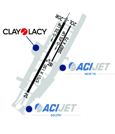
| Rwy | Rwy | |||||||
| 5700x150 | 5700' | 5700x150 | 5700' | 111.75 - 195° | ||||
| 2886x75 | 2886' | 2886x75 | 2886' | |||||
| Runway ID | Single Wheel | Double Wheel | Double Tandem Wheel | Dual Double Wheel |
| 02L/20R | 70,000 | 200,000 | 300,000 | N/A |
| 02R/20L | 25,000 | 60,000 | N/A | N/A |
| 20X | N/A | N/A | N/A | N/A |
| These numbers are Advisory and are not limits. The Airport Manager should have more accurate Weight Limits | ||||
 Airport Diagram might not be current. | |
| Facility Name: | JOHN WAYNE/ORANGE COUNTY |
| City Name: | SANTA ANA |
| County: | ORANGE |
| State abbrev: | CA |
| State Name: | CALIFORNIA |
| Ownership: | PUBLICLY OWNED |
| Use: | OPEN TO THE PUBLIC |
| Owner's Name: | ORANGE COUNTY |
| Address: | 3160 AIRWAY AVENUE |
| COSTA MESA, CA 92626 | |
| Owner's Phone: | 949-252-5171 |
| Manager's Name: | CHARLENE V. REYNOLDS; JEFFREY S. ROUNTREE, MGR, AIRSIDE OPNS (949) 252-5247. |
| Address: | 3160 AIRWAY AVE |
| COSTA MESA, CA 92626 | |
| Phone: | 949-252-5171 |
| FAA Region: | WESTERN-PACIFIC |
| FAA Field Office: | LAX |

| Date | Sunrise | Sunset |
|---|---|---|
| 04/23/24 Tuesday | 6:10 | 19:29 |
| 04/24/24 Wednesday | 6:09 | 19:30 |
| 04/25/24 Thursday | 6:08 | 19:31 |
| 04/26/24 Friday | 6:07 | 19:32 |
| 04/27/24 Saturday | 6:06 | 19:32 |
| 04/28/24 Sunday | 6:05 | 19:33 |
| 04/29/24 Monday | 6:04 | 19:34 |
| 04/30/24 Tuesday | 6:03 | 19:35 |
| 05/01/24 Wednesday | 6:02 | 19:35 |
| 05/02/24 Thursday | 6:01 | 19:36 |
| 05/03/24 Friday | 6:00 | 19:37 |
| 05/04/24 Saturday | 5:59 | 19:38 |
| 05/05/24 Sunday | 5:58 | 19:38 |
| 05/06/24 Monday | 5:57 | 19:39 |
| Airport Attendance Schedule | CONTINUOUS |
| Airport Status | OPERATIONAL (This Status can change at any time - please check NOTAMS) |
| Airport Lighting Schedule | WHEN ATCT CLSD ACTVT MALSR RY 20R & PAPI RYS 02L & 20R - CTAF. |
| Airport Storage Available | Tie Downs |
| Extra Services Available | Air Freight, Air Ambulance, Avionics, Charter, Flight Instruction, Aircraft Rental, Aircraft Sales, Annual Surveying |
| Wind Indicator | YES - (lighted) |
| Control Tower | YES |
| CTAF Frequency | 126.800 |
| Unicom Frequency | 122.950 |
| Rotating Beacon Color | WG |
| Segmented Circle | YES |
| Landing Fee | NO; OVERNIGHT TIE-DOWN FEE. |
| Airport Inspected | FEDERAL - performed by FAA AIRPORTS FIELD PERSONNEL |
| Inspection Date | 05/02/2023 |
| Type of Fuel Available | Grade 100LL, JET A (freeze point -40C) |
| Airframe Repair Service | MAJOR |
| Power Plant Repair Service | MAJOR |
| Latitude | N3340.5 |
| Longitude | W11752.1 (ESTIMATED) |
| Arpt Elevation | 55ft (SURVEYED) |
| Magnetic Variation | 12E |
| 4 miles S | of SANTA ANA |
| Traffic Pattern Altitude | |
| Sectional Chart | LOS ANGELES |
| Operations (Reported) | Yearly | Avg. Daily |
|---|---|---|
| General Aviation Transient | 81564 | 223 |
| General Aviation Local | 94751 | 260 |
| Air Taxi | 30000 | 82 |
| Commerical | 110037 | 301 |
| Commuter | 0 | 0 |
| Military | 444 | 1 |
| Aircraft based on Field | |
|---|---|
| General Aviation Singles | 230 |
| General Aviation Multi | 44 |
| Jet Aircraft | 77 |
| General Aviation Helicopters | 16 |
| Military Aircraft | 0 |
| Gliders | 0 |
| Ultralights | 0 |
| FSS on field | NO |
| FSS tie-in | RIVERSIDE |
| FSS Phone | 1-800-WX-BRIEF |
| Who issues Notams | SNA |
| Notam D service at airport | YES |
| ARTCC Name | LOS ANGELES |
| Airport Certification | AIRPORT RECEIVING SCHEDULED AIR CARRIER SERVICE FROM CARRIERS CERTIFICATED BY THE CIVIL AERONAUTICS BOARD |
| Aircraft Rescue & Firefighting Index | AIRPORT HAS A CERTIFICATE UNDER CFR PART 139 |
| Airport of Entry | No |
| Custom Landing Rights | No; US CUSTOMS USER FEE ARPT. |
| Joint Civil/Military | No |
| Military Landing rights | YES |
| NATIONAL PLAN OF INTEGRATED AIRPORT SYSTEMS (NPIAS) |
| GRANT AGREEMENTS UNDER FAAP/ADAP/AIP |
| SURPLUS PROPERTY AGREEMENT UNDER PUBLIC LAW 289 |
| ASSURANCES PURSUANT TO TITLE VI, CIVIL RIGHTS ACT OF 1964 |
| AGREEMENT UNDER DLAND OR DCLA HAS EXPIRED. |
| MAINTAIN AT OR ABOVE 300 FT AGL UNTIL ESTABLISHED ON FINAL . |
| FBO GENERAL AVIATION APRONS LIMITED TO MAX GWT OF 100,000 LBS (DUAL GEAR) AND WITH WINGSPANS LESS THAN 100 FT. GENERAL AVIATION AIRCRAFT PROHIBITED FROM USING ANY PORTION OF THE AIR CARRIER COMMERCIAL RAMP. |
| NOISE ABATEMENT PROCEDURES IN EFFECT CTC ARPT NOISE OFFICE (949) 252-5185. |
| RWY 02L/20R TPA 1000 FT AGL SMALL ACFT; 1500 FT AGL TURBINE ACFT OVER 12500 LBS; RWY 02R/20L TPA 800 FT AGL SMALL SGL ENG ACFT; 1000 FT AGL TWIN ENG ACFT. |
| ASDE-X IN USE. OPERATE TRANSPONDERS WITH ALTITUDE REPORTING MODE AND ADS-B (IF EQUIPPED) ENABLED ON ALL AIRPORT SURFACES. |
| FOR CD WHEN ATCT CLSD CTC SOCAL APCH AT 800-448-3724. |
| RWY 2R/20L NOT AVBL FOR SKED ACR OPNS WITH MORE THAN 9 PSGR SEATS OR UNSKED ACR OPNS WITH AT LEAST 31 PSGR SEATS. |
| ACFT LDG RWY 20L, USE CTN FOR JET BLAST FROM ACFT HLDG BTN RWY 20L AND RWY 20R AT TWY L. |
| VFR ACFT: TO AVOID OVERFLIGHT OF RWY 20R, RWY 20L ARRS FLY FINAL AT 15 DEG ANGLE TO RWY; RWY 20L DEPS TURN 15 DEGS LEFT AT DEP END OF RWY. TO AVOID OVERFLIGHT OF RWY 02L, RWY 02R DEPS TURN 15 DEGS RIGHT AT DEP END OF RWY. |
| WHEN ATCT CLSD NO LCL TRNG OR TOUCH & GO OPNS. |
| BE ALERT TO BIRDS ON AND IN VICINITY OF ARPT. |
| TWY C GWT LMTD 60000 LBS. |
| RWY 02R/ 20LRWY 02R/20L CLSD WHEN ATCT CLSD. |
| RWY 20X RY 20X CREATED TO SUPPORT OJW LDA ASSOCIATED WITH SNA ILS RY 20R. |
Airport Communications & Frequencies:
| |||||||||||||||||||||||||||||||||||||||||||||||||||||||||||||||
| Runway: 02L | Runway: 20R | ||
| Mag heading: | 16° | Mag heading: | 196° |
| Rwy Slope: | -.26% Down | Rwy Slope: | .26% Up |
| Approach: | Approach: | ILS/DME | |
| Pattern: | Left Traffic | Pattern: | Right Traffic |
| Markings: | PRECISION INSTRUMENT | Markings: | PRECISION INSTRUMENT |
| Marking Condition: | GOOD | Marking Condition: | GOOD |
| Arresting Dev: | Arresting Dev: | ||
| Lat & Long: | N3340.1 W11752.4 | Lat. & Long.: | N3340.9 W11751.9 |
| Elev: | 55.9 ft. MSL | Elev: | 41.2 ft. MSL |
| TCH: | 75 ft. AGL | TCH: | 68 ft. AGL |
| Visual Glide Path: | 3.00 degrees | Visual Glide Path: | 3.00 degrees |
| Displaced Threshold: | No | Displaced Threshold: | No |
| Touchdown Zone: | YES | Touchdown Zone: | YES |
| Touchdown Elev.: | 55.9 feet | Touchdown Elev.: | 53.9 feet |
| Visual Glide Slope: | 4-Light PAPI on LEFT side of Runway | Visual Glide Slope: | 4-Light PAPI on LEFT side of Runway |
| RVR Equipment: | ROLLOUT | RVR Equipment: | TOUCHDOWN |
| RVV Equipment: | NO | RVV Equipment: | NO |
| Approach Lights: | Approach Lights: | MALSR - 1,400 foot medium intensity approach lighting system with runway alignment indicator lights | |
| REIL: | NO | REIL: | NO |
| Centerline Lights: | NO | Centerline Lights: | NO |
| Touchdown lights: | NO | Touchdown lights: | NO |
| Runway Category: | Runway with a Non-precision Approach having visibility minimums greater than 3/4 mile | Runway Category: | Precision Instrument Runway |
| Declared Distances: | TORA:5700' TODA:5700' ASDA:5700' LDA:5700' | Declared Distances: | TORA:5700' TODA:5700' ASDA:5700' LDA:5700' |
| Runway: 02R | Runway: 20L | ||
| Mag heading: | 16° | Mag heading: | 196° |
| Rwy Slope: | -.43% Down | Rwy Slope: | .43% Up |
| Approach: | Approach: | ||
| Pattern: | Right Traffic | Pattern: | Left Traffic |
| Markings: | BASIC | Markings: | BASIC |
| Marking Condition: | GOOD | Marking Condition: | GOOD |
| Arresting Dev: | Arresting Dev: | ||
| Lat & Long: | N3340.4 W11752.1 | Lat. & Long.: | N3340.9 W11751.8 |
| Elev: | 52.0 ft. MSL | Elev: | 39.7 ft. MSL |
| TCH: | TCH: | 26 ft. AGL | |
| Visual Glide Path: | Visual Glide Path: | 3.00 degrees | |
| Displaced Threshold: | No | Displaced Threshold: | No |
| Touchdown Zone: | YES | Touchdown Zone: | YES |
| Touchdown Elev.: | 52.0 feet | Touchdown Elev.: | 52.0 feet |
| Visual Glide Slope: | Visual Glide Slope: | 4-Light PAPI on LEFT side of Runway | |
| RVR Equipment: | RVR Equipment: | ||
| RVV Equipment: | NO | RVV Equipment: | NO |
| Approach Lights: | Approach Lights: | ||
| REIL: | NO | REIL: | YES |
| Centerline Lights: | NO | Centerline Lights: | NO |
| Touchdown lights: | NO | Touchdown lights: | NO |
| Runway Category: | Runway with a Visual Approach | Runway Category: | Runway with a Visual Approach |
| Declared Distances: | Declared Distances: | ||
| Obstructions: | Obstructions: | BLDG | |
| Marked: | Marked: | LIGHTED | |
| Clearance slope: | 20:1 | Clearance slope: | 20:1 |
| Obstruction height: | Obstruction height: | 15 feet AGL | |
| Dist. from runway: | Dist. from runway: | 500 feet | |
| Centerline offset: | Centerline offset: | 115 feet left of centerline | |
| Comments: | Comments: |