KSMX

SANTA MARIA PUB/HANCOCK
SANTA MARIA
CA
Time Zone: Pacific
Lat: N 3454.0
Long: W 12027.5
Elev: 261
Var: -14
Longest Runway: 8004
Dept. ATIS: 121.15
Arr. ATIS: 121.15
Ground: 121.9
Tower: 118.3

FBO & Flight Services info for KSMX

FBOs: Update your Fuel Prices

CENTRAL COAST JETPh: 888-934-2252 Fax: 805-934-2674 Freq: 129.97
Service
Jet
100LL
SAF
MoGas
Fuel Avail: PRIST PREMIXED 6:00am to 9:00pm, After hour call out is $150
Full6.136.86    Last Update: 04/09/2024 19:02
PRICES GUARANTEED by FBO. *
*Call for discount fuel pricing
Self  6.11    
 Address: 1211 CITATION CT,   SANTA MARIA, CA 93455-2805
ASOSPh: 805-928-0384
-
Freq: 121.15  
ATISPh: 805-347-9136
-
-
 
If you are an FBO, call 1-203-262-1700 to update your info or email: FltPlan.Advertising@garmin.com
Advertise your FBO on FltPlan.com

Runway & Approach Info for KSMX
Rwy
Length
Land Dist**
Approach*
  Rwy
Length
Land Dist**
Approach*
02
5199x75  5199'          
 
  
20
  5199x75  5199'          
 
12
8004x150  8004'          
ILS/DME
 108.90 - 120°  
  
30
  8004x150  8004'          
 
 * only ILS, LOC, LDA, and SDF approaches to a specific runway are shown
** For any Declared Landing Distance Available, please see A/FD or Approach plates
Runway Weight Capability (lbs.) Help
Runway IDSingle WheelDouble WheelDouble Tandem WheelDual Double Wheel
02/2070,00090,000150,000N/A
12/3075,000181,000400,000N/A
These numbers are Advisory and are not limits.   The Airport Manager should have more accurate Weight Limits
Approach Charts
Approaches    
Current Weather/Notams
Customs Information Send updates to Support@FltPlan.com
Customs Not Available
Database effective 04/18/2024
Airport Diagram of KSMX
Airport Diagram might not be current.

Facility Name: SANTA MARIA PUB/CAPT G ALLAN HANCOCK FLD
City Name: SANTA MARIA
County: SANTA BARBARA
State abbrev: CA
State Name: CALIFORNIA
   
Ownership: PUBLICLY OWNED
Use: OPEN TO THE PUBLIC
Owner's Name: SANTA MARIA PUBLIC APT DIST
Address: 3217 TERMINAL DR
 SANTA MARIA, CA 93455
Owner's Phone: 805-922-1726
  
Manager's Name: MARTIN PEHL
Address: 3217 TERMINAL DR
 SANTA MARIA, CA 93455
Phone: 805-922-1726
   
FAA Region: WESTERN-PACIFIC
FAA Field Office: LAX


Sunrise / Sunset times for SANTA MARIA PUB/CAPT G ALLAN HANCOCK FLD

DateSunriseSunset
04/18/24 Thursday6:2519:37
04/19/24 Friday6:2419:38
04/20/24 Saturday6:2319:39
04/21/24 Sunday6:2119:40
04/22/24 Monday6:2019:41
04/23/24 Tuesday6:1919:41
04/24/24 Wednesday6:1819:42
04/25/24 Thursday6:1719:43
04/26/24 Friday6:1619:44
04/27/24 Saturday6:1519:45
04/28/24 Sunday6:1319:45
04/29/24 Monday6:1219:46
04/30/24 Tuesday6:1119:47
05/01/24 Wednesday6:1019:48

Airport Facilities

Airport Attendance Schedule7 Days A Week 0600-2200
Airport Status OPERATIONAL (This Status can change at any time - please check NOTAMS)
Airport Lighting ScheduleWHEN ATCT CLSD ACTVT MALSR RWY 12; PAPI RWY 30; HIRL RWY 12/30; TWY LIGHTS - CTAF. PAPI RWY 12 OPER CONSLY.
Airport Storage AvailableTie Downs
Extra Services AvailableAir Freight, Avionics, Charter, Flight Instruction, Aircraft Rental, Aircraft Sales
Wind IndicatorYES - (lighted)
Control TowerYES
CTAF Frequency118.300
Unicom Frequency122.950
Rotating Beacon ColorWG
Segmented CircleYES
Landing FeeNO

Airport Inspection Data

Airport InspectedFEDERAL - performed by FAA AIRPORTS FIELD PERSONNEL
Inspection Date02/29/2024

Airport Services

Type of Fuel AvailableGrade 100LL, JET A (freeze point -40C); -10ACFT FUEL SERVICING AVAILABLE 129.975.
Airframe Repair ServiceMAJOR
Power Plant Repair ServiceMAJOR

Geographic Data

LatitudeN3454.0
LongitudeW12027.5 (ESTIMATED)
Arpt Elevation261ft (SURVEYED)
Magnetic Variation14E
3 miles Sof SANTA MARIA
Traffic Pattern AltitudeTPA 1000; TURBOJET & PURE JET 1500.
Sectional ChartLOS ANGELES

Aircraft Data

Operations (Reported)YearlyAvg. Daily
General Aviation Transient 1433039
General Aviation Local 897725
Air Taxi 475513
Commerical 2021
Commuter 00
Military 21976
Aircraft based on Field
General Aviation Singles 187
General Aviation Multi 12
Jet Aircraft 5
General Aviation Helicopters 9
Military Aircraft 0
Gliders 1
Ultralights 3

FAA Services

FSS on field NO
FSS tie-in HAWTHORNE
FSS Phone 1-800-WX-BRIEF
Who issues Notams SMX
Notam D service at airport YES
ARTCC Name LOS ANGELES

Federal Status

Airport CertificationAIRPORT RECEIVING SCHEDULED AIR CARRIER SERVICE FROM CARRIERS CERTIFICATED BY THE CIVIL AERONAUTICS BOARD; CLSD TO SUPPLL PART 121 AND PART 135 ACR OPNS EXCP 24 HRS PPR, CALL AMGR (805) 922-1726 WKDAYS 0800-1700. RWY 2/20 NOT AVBL FOR SKED ACR OPNS WITH MORE THAN 9 PSGR SEATS OR UNSKED ACR AT LEAST 31 PSGR SEATS.
Aircraft Rescue & Firefighting IndexAIRPORT HAS A CERTIFICATE UNDER CFR PART 139
Airport of EntryNo
Custom Landing RightsNo
Joint Civil/MilitaryNo
Military Landing rightsYES

Federal Agreements

NATIONAL PLAN OF INTEGRATED AIRPORT SYSTEMS (NPIAS)
GRANT AGREEMENTS UNDER FAAP/ADAP/AIP
SURPLUS PROPERTY AGREEMENT UNDER PUBLIC LAW 289
ASSURANCES PURSUANT TO TITLE VI, CIVIL RIGHTS ACT OF 1964

Remarks

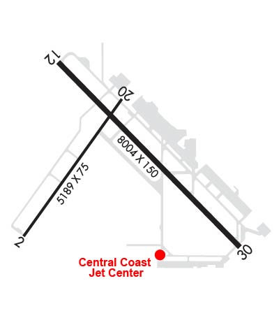
RUNUP APRON RY 30 GWT 110,000 LBS DW.
CAUTION PARALLEL LGTD ROAD LESS THAN 1/4 MILE NW OF RY 12/30.
TRANSIENT PILOTS REMAIN CLEAR OF COMMERCIAL RAMP AND TERMINAL.
SELF SERVE FUEL 100LL AVBL 24 HRS LOCATED NORTH OF TOWER.
RWY 2/20 NOT AVBL FOR ACR USE.
CALM WIND LESS THAN 8 KNOTS USE RWY 30.
NO TGL OPNS; LANDING PRACTICE OR PRACTICE INSTRUMENT APPROACHES 2200-0700.
PORTIONS OF TWY J NOT VISIBLE FM ATCT & UNLGTD.
NUMEROUS BIRDS ON AND INVOF ARPT.
Airport Communications & Frequencies:
ATIS Frequencies:   Hours(local) of Operation: CONTINUOUS
121.15
SANTA MARIA Tower Frequencies:   Hours(local) of operation: 0600-2000   
118.3
239.25
SANTA MARIA Ground Frequencies:
121.9
Emergency Frequencies:
121.5
CTAF Frequency:
118.300
Unicom Frequency:
122.950
Remarks
  • APCH/DEP CTL SVC PRVDD BY LOS ANGELES ARTCC (ZLA) ON FREQS 119.05/269.5 (SAN LUIS OBISPO RCAG) WHEN SANTA BARBARA APCH CTL (SBA) CLSD.
  • COMMUNICATIONS PRVDD BY HAWTHORNE RADIO ON FEQS 122.1R/111.0T (GUADALUPE RCO).
  • SANTA BARBARA Primary Approach Frequencies:  
    124.15
    327.8
    SANTA BARBARA Primary Departure Frequencies:  
    124.15
    327.8
    Runway Identifications
    Runway Identification: 02/20
    Length: 5199 ft
    Width: 75 ft
    Surface: ASPHALT-GOOD CONDITION
    Edge lights:

    Treatment: NONE
    Weight: PCN 6 /F/B/Y/U

     Runway: 02   Runway: 20
    Mag heading: 22°Mag heading: 202°
    Rwy Slope: .32% UpRwy Slope: -.32% Down
    Approach: Approach:
    Pattern: Right TrafficPattern: Left Traffic
    Markings: BASICMarkings: BASIC
    Marking Condition: GOODMarking Condition: GOOD
    Arresting Dev: Arresting Dev:
    Lat & Long: N3453.6  W12028.1Lat. & Long.: N3454.3  W12027.5
    Elev: 209.5 ft. MSLElev: 226.2 ft. MSL
    TCH: TCH:
    Visual Glide Path: Visual Glide Path:
    Displaced Threshold: NoDisplaced Threshold: No
    Touchdown Zone: YESTouchdown Zone: YES
    Touchdown Elev.: 216.9 feetTouchdown Elev.: 226.7 feet
    Visual Glide Slope: Visual Glide Slope:
    RVR Equipment: RVR Equipment:
    RVV Equipment: NORVV Equipment: NO
    Approach Lights: Approach Lights:
    REIL: NOREIL: NO
    Centerline Lights: NOCenterline Lights: NO
    Touchdown lights: NOTouchdown lights: NO
    Runway Category: Runway with a Visual ApproachRunway Category: Runway with a Visual Approach
    Declared Distances: TORA:5199' TODA:5199' ASDA:5199' LDA:5199'Declared Distances: TORA:5199' TODA:5199' ASDA:5199' LDA:5199'
    Obstructions: Obstructions: TREES
    Marked: Marked: NOT Marked/Lighted
    Clearance slope: 50:1Clearance slope: 28:1
    Obstruction height: Obstruction height: 121 feet AGL
    Dist. from runway: Dist. from runway: 3640 feet
    Centerline offset: Centerline offset: 350 feet right of centerline
    Comments: Comments:
    Runway Identification: 12/30
    Length: 8004 ft
    Width: 150 ft
    Surface: ASPHALT-GOOD CONDITION
    Edge lights: High Intensity

    Treatment: GROOVED
    Weight: PCN 56 /F/B/X/U

     Runway: 12   Runway: 30
    Mag heading: 121°Mag heading: 301°
    Rwy Slope: .55% UpRwy Slope: -.55% Down
    Approach: ILS/DMEApproach:
    Pattern: Right TrafficPattern: Left Traffic
    Markings: PRECISION INSTRUMENTMarkings: PRECISION INSTRUMENT
    Marking Condition: GOODMarking Condition: GOOD
    Arresting Dev: Arresting Dev:
    Lat & Long: N3454.5  W12027.9Lat. & Long.: N3453.6  W12026.7
    Elev: 216.8 ft. MSLElev: 261.1 ft. MSL
    TCH: 55 ft. AGLTCH: 46 ft. AGL
    Visual Glide Path: 3.00 degreesVisual Glide Path: 3.60 degrees
    Displaced Threshold: NoDisplaced Threshold: No
    Touchdown Zone: YESTouchdown Zone: YES
    Touchdown Elev.: 230.1 feetTouchdown Elev.: 261.2 feet
    Visual Glide Slope: 4-Light PAPI on RIGHT side of RunwayVisual Glide Slope: 4-Light PAPI on RIGHT side of Runway
    RVR Equipment: TOUCHDOWNRVR Equipment: ROLLOUT
    RVV Equipment: NORVV Equipment: NO
    Approach Lights: MALSR - 1,400 foot medium intensity approach lighting system with runway alignment indicator lightsApproach Lights:
    REIL: NOREIL: NO
    Centerline Lights: NOCenterline Lights: NO
    Touchdown lights: NOTouchdown lights: NO
    Runway Category: Precision Instrument RunwayRunway Category: Runway with a Non-precision Approach having visibility minimums greater than 3/4 mile
    Declared Distances: TORA:8004' TODA:8004' ASDA:8004' LDA:8004'Declared Distances: TORA:8004' TODA:8004' ASDA:8004' LDA:8004'
    Obstructions: Obstructions: TREES
    Marked: Marked: NOT Marked/Lighted
    Clearance slope: 50:1Clearance slope: 20:1
    Obstruction height: Obstruction height: 225 feet AGL
    Dist. from runway: Dist. from runway: 4700 feet
    Centerline offset: Centerline offset: 800 feet left of centerline
    Comments: Comments:
    C:37/P: