Current Weather/Notams (Metars, TAFs, Notams, NWS Forecast, PIREPS, and nearby weather)
Customs Information Send updates to Support@FltPlan.com
Customs Not Available
Database effective 05/16/2024
Airport Diagram might not be current. Facility Name: SUMTER City Name: SUMTER County: SUMTER State abbrev: SC State Name: SOUTH CAROLINA Ownership: PUBLICLY OWNED Use: OPEN TO THE PUBLIC Owner's Name: COUNTY OF SUMTER Address: 13 EAST CANAL STREET SUMTER, SC 29150 Owner's Phone: (803) 469-4639 Manager's Name: JEFF KNAUER Address: 2945 AIRPORT ROAD SUMTER, SC 29153 Phone: 803-469-4639 FAA Region: SOUTHERN FAA Field Office: ATL
Runway Identifications Help
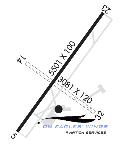
Runway Identification: 05/23 Length: 5501 ftWidth: 100 ftSurface: ASPHALT-GOOD CONDITIONEdge lights: Medium Intensity Treatment: NONEWeight: PCN 12 /F/D/Y/T Runway: 05 Runway: 23 Mag heading: 50° Mag heading: 230° Rwy Slope: .06% Up Rwy Slope: -.06% Down Approach: Approach: ILS/DME Pattern: Right Traffic Pattern: Left Traffic Markings: NONPRECISION INSTRUMENT Markings: PRECISION INSTRUMENT Marking Condition: GOOD Marking Condition: GOOD Arresting Dev: Arresting Dev: Lat & Long: N3359.4 W08022.1 Lat. & Long.: N3400.1 W08021.3 Elev: 178.7 ft. MSL Elev: 181.8 ft. MSL TCH: 46 ft. AGL TCH: 45 ft. AGL Visual Glide Path: 3.00 degrees Visual Glide Path: 3.00 degrees Displaced Threshold: No Displaced Threshold: No Touchdown Zone: YES Touchdown Zone: YES Touchdown Elev.: 180.7 feet Touchdown Elev.: 182.1 feet Visual Glide Slope: 4-Light PAPI on LEFT side of Runway Visual Glide Slope: 4-Light PAPI on LEFT side of Runway RVR Equipment: RVR Equipment: RVV Equipment: NO RVV Equipment: NO Approach Lights: Approach Lights: ODALS - omnidirectional approach lighting system REIL: YES REIL: YES Centerline Lights: NO Centerline Lights: NO Touchdown lights: NO Touchdown lights: NO Runway Category: Runway with a Non-precision Approach having visibility minimums greater than 3/4 mile Runway Category: Precision Instrument Runway Declared Distances: Declared Distances: Obstructions: TREES Obstructions: TREES Marked: NOT Marked/Lighted Marked: NOT Marked/Lighted Clearance slope: 28:1 Clearance slope: 29:1 Obstruction height: 77 feet AGL Obstruction height: 87 feet AGL Dist. from runway: 2373 feet Dist. from runway: 2748 feet Centerline offset: 565 left of centerline Centerline offset: 659 feet left of centerline Comments: Comments:
Runway Identification: 14/32 Length: 3081 ftWidth: 120 ftSurface: GRASS-GOOD CONDITIONEdge lights: Treatment: NONE Runway: 14 Runway: 32 Mag heading: 141° Mag heading: 321° Rwy Slope: .08% Up Rwy Slope: -.08% Down Approach: Approach: Pattern: Left Traffic Pattern: Right Traffic Markings: NONE Markings: NONE Marking Condition: Marking Condition: Arresting Dev: Arresting Dev: Lat & Long: N3359.8 W08021.9 Lat. & Long.: N3359.5 W08021.4 Elev: 176.9 ft. MSL Elev: 179.3 ft. MSL TCH: TCH: Visual Glide Path: Visual Glide Path: Displaced Threshold: No Displaced Threshold: No Touchdown Zone: YES Touchdown Zone: YES Touchdown Elev.: 180.7 feet Touchdown Elev.: 180.7 feet Visual Glide Slope: Visual Glide Slope: RVR Equipment: RVR Equipment: RVV Equipment: NO RVV Equipment: NO Approach Lights: Approach Lights: REIL: NO REIL: NO Centerline Lights: NO Centerline Lights: NO Touchdown lights: NO Touchdown lights: NO Runway Category: Runway with a Visual Approach Runway Category: Runway with a Visual Approach Declared Distances: Declared Distances: Obstructions: TREES Obstructions: TREE Marked: NOT Marked/Lighted Marked: NOT Marked/Lighted Clearance slope: 8:1 Clearance slope: 12:1 Obstruction height: 84 feet AGL Obstruction height: 94 feet AGL Dist. from runway: 941 feet Dist. from runway: 1369 feet Centerline offset: 152 left of centerline Centerline offset: 113 feet right of centerline Comments: Comments: