Current Weather/Notams (Metars, TAFs, Notams, NWS Forecast, PIREPS, and nearby weather)
Customs Information Send updates to Support@FltPlan.com
Customs Not Available
Database effective 04/18/2024
Airport Diagram might not be current.
|
| Facility Name: | SOMERSET |
| City Name: | SOMERVILLE |
| County: | SOMERSET |
| State abbrev: | NJ |
| State Name: | NEW JERSEY |
| | |
| Ownership: | PRIVATELY OWNED |
| Use: | OPEN TO THE PUBLIC |
| Owner's Name: | SOMERSET AIR SERVICE, INC |
| Address: | PO BOX 1007 |
| | BEDMINSTER, NJ 07921 |
| Owner's Phone: | 908-722-2444 |
| | |
| Manager's Name: | CHRIS WALKER, PRES. |
| Address: | PO BOX 1007 |
| | BEDMINSTER, NJ 07921 |
| Phone: | 908-722-2444 |
| | |
| FAA Region: | EASTERN |
| FAA Field Office: | HAR |
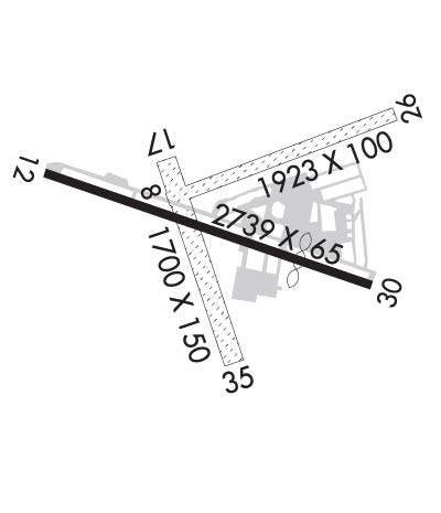
Runway Identifications
Runway Identification: 08/26Length: 1923 ft
Width: 100 ft
Surface: GRASS-GOOD CONDITION
Edge lights: Treatment: NONE
| | Runway: 08 | | Runway: 26 |
| Mag heading: | 82° | Mag heading: | 262° |
| Rwy Slope: | .41% Up | Rwy Slope: | -.41% Down |
| Approach: | | Approach: | |
| Pattern: | Left Traffic | Pattern: | Right Traffic |
| Markings: | NONE | Markings: | NONE |
| Marking Condition: | | Marking Condition: | |
| Arresting Dev: | | Arresting Dev: | |
| Lat & Long: | N4037.6 W07440.3 | Lat. & Long.: | N4037.7 W07439.9 |
| Elev: | 95.0 ft. MSL | Elev: | 102.9 ft. MSL |
| TCH: | | TCH: | |
| Visual Glide Path: | | Visual Glide Path: | |
| Displaced Threshold: | No | Displaced Threshold: | No |
| Touchdown Zone: | YES | Touchdown Zone: | YES |
| Touchdown Elev.: | 106.2 feet | Touchdown Elev.: | 106.2 feet |
| Visual Glide Slope: | | Visual Glide Slope: | |
| RVR Equipment: | | RVR Equipment: | |
| RVV Equipment: | NO | RVV Equipment: | NO |
| Approach Lights: | | Approach Lights: | |
| REIL: | NO | REIL: | NO |
| Centerline Lights: | NO | Centerline Lights: | NO |
| Touchdown lights: | NO | Touchdown lights: | NO |
| Runway Category: | Runway with a Non-precision Approach | Runway Category: | Runway with a Visual Approach |
| Declared Distances: | | Declared Distances: | |
| Obstructions: | TREE | Obstructions: | TREE |
| Marked: | NOT Marked/Lighted | Marked: | NOT Marked/Lighted |
| Clearance slope: | 3:1 | Clearance slope: | |
| Obstruction height: | 51 feet AGL | Obstruction height: | 45 feet AGL |
| Dist. from runway: | 200 feet | Dist. from runway: | 10 feet |
| Centerline offset: | 50 left of centerline | Centerline offset: | 140 feet right of centerline |
| Comments: | | Comments: | |
Runway Identification: 12/30Length: 2739 ft
Width: 65 ft
Surface: ASPHALT-GOOD CONDITION
Edge lights: Medium IntensityTreatment: NONE
| | Runway: 12 | | Runway: 30 |
| Mag heading: | 122° | Mag heading: | 302° |
| Rwy Slope: | .66% Up | Rwy Slope: | -.66% Down |
| Approach: | | Approach: | |
| Pattern: | Left Traffic | Pattern: | Left Traffic |
| Markings: | NONPRECISION INSTRUMENT | Markings: | NONPRECISION INSTRUMENT |
| Marking Condition: | GOOD | Marking Condition: | GOOD |
| Arresting Dev: | | Arresting Dev: | |
| Lat & Long: | N4037.6 W07440.5 | Lat. & Long.: | N4037.5 W07440.0 |
| Elev: | 83.9 ft. MSL | Elev: | 102.1 ft. MSL |
| TCH: | 30 ft. AGL | TCH: | 43 ft. AGL |
| Visual Glide Path: | 3.00 degrees | Visual Glide Path: | 4.00 degrees |
| Displaced Threshold: | No | Displaced Threshold: | 200 feet |
| Touchdown Zone: | YES | Touchdown Zone: | YES |
| Touchdown Elev.: | 104.3 feet | Touchdown Elev.: | 104.3 feet |
| Visual Glide Slope: | 2-Light PAPI on RIGHT side of Runway | Visual Glide Slope: | 2-Light PAPI on LEFT side of Runway |
| RVR Equipment: | | RVR Equipment: | |
| RVV Equipment: | NO | RVV Equipment: | NO |
| Approach Lights: | | Approach Lights: | |
| REIL: | YES | REIL: | YES |
| Centerline Lights: | NO | Centerline Lights: | NO |
| Touchdown lights: | NO | Touchdown lights: | NO |
| Runway Category: | Runway with a Non-precision Approach | Runway Category: | Runway with a Non-precision Approach |
| Declared Distances: | | Declared Distances: | |
| Obstructions: | TREES | Obstructions: | TREES |
| Marked: | NOT Marked/Lighted | Marked: | NOT Marked/Lighted |
| Clearance slope: | 7:1 | Clearance slope: | 9:1; APCH RATIO 15:1 TO DTHR. |
| Obstruction height: | 55 feet AGL | Obstruction height: | 65 feet AGL |
| Dist. from runway: | 587 feet | Dist. from runway: | 795 feet |
| Centerline offset: | 163 right of centerline | Centerline offset: | 280 feet left of centerline |
| Comments: | | Comments: | |
Runway Identification: 17/35Length: 1700 ft
Width: 150 ft
Surface: GRASS-GOOD CONDITION
Edge lights: Treatment: NONE
| | Runway: 17 | | Runway: 35 |
| Mag heading: | 174° | Mag heading: | 354° |
| Rwy Slope: | -.58% Down | Rwy Slope: | .58% Up |
| Approach: | | Approach: | |
| Pattern: | Left Traffic | Pattern: | Left Traffic |
| Markings: | NONE | Markings: | NONE |
| Marking Condition: | | Marking Condition: | |
| Arresting Dev: | | Arresting Dev: | |
| Lat & Long: | N4037.6 W07440.3 | Lat. & Long.: | N4037.4 W07440.2 |
| Elev: | 97.2 ft. MSL | Elev: | 87.4 ft. MSL |
| TCH: | | TCH: | |
| Visual Glide Path: | | Visual Glide Path: | |
| Displaced Threshold: | No | Displaced Threshold: | No |
| Touchdown Zone: | YES | Touchdown Zone: | YES |
| Touchdown Elev.: | 97.2 feet | Touchdown Elev.: | 97.2 feet |
| Visual Glide Slope: | | Visual Glide Slope: | |
| RVR Equipment: | | RVR Equipment: | |
| RVV Equipment: | NO | RVV Equipment: | NO |
| Approach Lights: | | Approach Lights: | |
| REIL: | NO | REIL: | NO |
| Centerline Lights: | NO | Centerline Lights: | NO |
| Touchdown lights: | NO | Touchdown lights: | NO |
| Runway Category: | Runway with a Visual Approach | Runway Category: | Runway with a Visual Approach |
| Declared Distances: | | Declared Distances: | |
| Obstructions: | TREES | Obstructions: | TREES |
| Marked: | NOT Marked/Lighted | Marked: | NOT Marked/Lighted |
| Clearance slope: | | Clearance slope: | |
| Obstruction height: | 65 feet AGL | Obstruction height: | 22 feet AGL |
| Dist. from runway: | 20 feet | Dist. from runway: | 10 feet |
| Centerline offset: | 120 right of centerline | Centerline offset: | 90 feet left of centerline |
| Comments: | | Comments: | |

