Current Weather/Notams (Metars, TAFs, Notams, NWS Forecast, PIREPS, and nearby weather)
Customs Information Send updates to Support@FltPlan.com
Customs Not Available
Database effective 05/16/2024
Airport Diagram might not be current.
|
| Facility Name: | LAKE CUMBERLAND RGNL |
| City Name: | SOMERSET |
| County: | PULASKI |
| State abbrev: | KY |
| State Name: | KENTUCKY |
| | |
| Ownership: | PUBLICLY OWNED |
| Use: | OPEN TO THE PUBLIC |
| Owner's Name: | SOMERSET-PULASKI COUNTY |
| Address: | 500 W.O. NEWELL DRIVE |
| | SOMERSET, KY 42501 |
| Owner's Phone: | 606-679-7908 |
| | |
| Manager's Name: | KELLIE BAKER |
| Address: | 500 W.O. NEWELL DRIVE |
| | SOMERSET, KY 42501 |
| Phone: | 606-679-7908 |
| | |
| FAA Region: | SOUTHERN |
| FAA Field Office: | MEM |
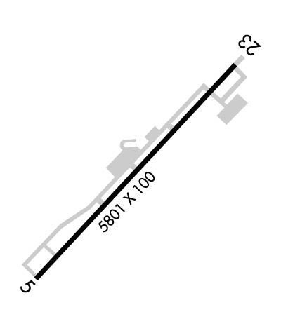
Runway Identifications
Runway Identification: 05/23Length: 5801 ft
Width: 100 ft
Surface: ASPHALT-GOOD CONDITION
Edge lights: Medium IntensityTreatment: NONE
Weight: PCN 18 /F/C/X/T
| | Runway: 05 | | Runway: 23 |
| Mag heading: | 48° | Mag heading: | 228° |
| Rwy Slope: | .18% Up | Rwy Slope: | -.18% Down |
| Approach: | ILS/DME | Approach: | |
| Pattern: | Left Traffic | Pattern: | Left Traffic |
| Markings: | PRECISION INSTRUMENT | Markings: | NONPRECISION INSTRUMENT |
| Marking Condition: | GOOD | Marking Condition: | GOOD |
| Arresting Dev: | | Arresting Dev: | |
| Lat & Long: | N3702.9 W08437.3 | Lat. & Long.: | N3703.6 W08436.5 |
| Elev: | 910.8 ft. MSL | Elev: | 921.0 ft. MSL |
| TCH: | 60 ft. AGL | TCH: | 54 ft. AGL |
| Visual Glide Path: | 3.00 degrees | Visual Glide Path: | 3.00 degrees |
| Displaced Threshold: | 514 feet | Displaced Threshold: | 300 feet |
| Touchdown Zone: | YES | Touchdown Zone: | YES |
| Touchdown Elev.: | 927.3 feet | Touchdown Elev.: | 927.3 feet |
| Visual Glide Slope: | 2-Light PAPI on RIGHT side of Runway | Visual Glide Slope: | 2-Light PAPI on LEFT side of Runway |
| RVR Equipment: | | RVR Equipment: | |
| RVV Equipment: | NO | RVV Equipment: | NO |
| Approach Lights: | | Approach Lights: | |
| REIL: | YES | REIL: | YES |
| Centerline Lights: | NO | Centerline Lights: | NO |
| Touchdown lights: | NO | Touchdown lights: | NO |
| Runway Category: | Precision Instrument Runway | Runway Category: | Runway with a Non-precision Approach having visibility minimums greater than 3/4 mile |
| Declared Distances: | TORA:5800' TODA:5800' ASDA:5800' LDA:5287' | Declared Distances: | TORA:5800' TODA:5800' ASDA:5800' LDA:5500' |
| Obstructions: | TREE | Obstructions: | TREES |
| Marked: | NOT Marked/Lighted | Marked: | NOT Marked/Lighted |
| Clearance slope: | 8:1; APCH RATIO 14:1 TO DTHR. | Clearance slope: | 17:1; APCH RATIO 19:1 TO DTHR. |
| Obstruction height: | 103 feet AGL | Obstruction height: | 338 feet AGL |
| Dist. from runway: | 1028 feet | Dist. from runway: | 6170 feet |
| Centerline offset: | 882 left of centerline | Centerline offset: | 919 feet left of centerline |
| Comments: | | Comments: | |

