Current Weather/Notams (Metars, TAFs, Notams, NWS Forecast, PIREPS, and nearby weather)
Customs Information Send updates to Support@FltPlan.com
Customs Not Available
Database effective 05/16/2024
Airport Diagram might not be current.
|
| Facility Name: | SMITH FLD |
| City Name: | FORT WAYNE |
| County: | ALLEN |
| State abbrev: | IN |
| State Name: | INDIANA |
| | |
| Ownership: | PUBLICLY OWNED |
| Use: | OPEN TO THE PUBLIC |
| Owner's Name: | FT WAYNE ALLEN CO APT ATHRTY |
| Address: | 3801 W FERGUSON ROAD-RM 209 |
| | FT WAYNE, IN 46809 |
| Owner's Phone: | 260-747-4146 |
| | |
| Manager's Name: | SCOTT D. HINDERMAN, A.A.E. |
| Address: | 3801 WEST FERGUSON ROAD, STE. 209 |
| | FORT WAYNE, IN 46809 |
| Phone: | 260-747-4146 |
| | |
| FAA Region: | GREAT LAKES |
| FAA Field Office: | CHI |
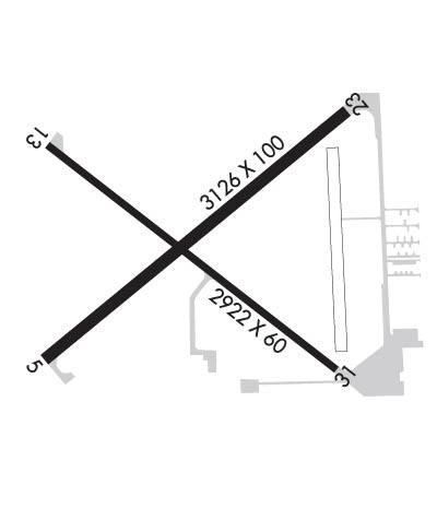
Runway Identifications
Runway Identification: 05/23Length: 3126 ft
Width: 100 ft
Surface: ASPHALT-GOOD CONDITION
Edge lights: Medium IntensityTreatment: NONE
| | Runway: 05 | | Runway: 23 |
| Mag heading: | 56° | Mag heading: | 236° |
| Rwy Slope: | .03% Up | Rwy Slope: | -.03% Down |
| Approach: | | Approach: | |
| Pattern: | Left Traffic | Pattern: | Left Traffic |
| Markings: | NONPRECISION INSTRUMENT | Markings: | NONPRECISION INSTRUMENT |
| Marking Condition: | GOOD | Marking Condition: | GOOD |
| Arresting Dev: | | Arresting Dev: | |
| Lat & Long: | N4108.5 W08509.4 | Lat. & Long.: | N4108.8 W08508.9 |
| Elev: | 827.0 ft. MSL | Elev: | 828.0 ft. MSL |
| TCH: | 43 ft. AGL | TCH: | 40 ft. AGL |
| Visual Glide Path: | 4.00 degrees | Visual Glide Path: | 3.05 degrees |
| Displaced Threshold: | 201 feet | Displaced Threshold: | 91 feet |
| Touchdown Zone: | YES | Touchdown Zone: | YES |
| Touchdown Elev.: | 834.0 feet | Touchdown Elev.: | 834.0 feet |
| Visual Glide Slope: | 2-Light PAPI on LEFT side of Runway; PAPI RSTRD BYD 7 DEGS LEFT & RIGHT OF CNTRLN. | Visual Glide Slope: | 2-Light PAPI on LEFT side of Runway; PAPI UNUSBL BYD 7 DEGS LEFT & RIGHT OF CNTRLN. |
| RVR Equipment: | | RVR Equipment: | |
| RVV Equipment: | NO | RVV Equipment: | NO |
| Approach Lights: | | Approach Lights: | |
| REIL: | NO | REIL: | NO |
| Centerline Lights: | NO | Centerline Lights: | NO |
| Touchdown lights: | NO | Touchdown lights: | NO |
| Runway Category: | Runway with a Non-precision Approach | Runway Category: | Runway with a Non-precision Approach |
| Declared Distances: | | Declared Distances: | |
| Obstructions: | CROPS | Obstructions: | ROAD |
| Marked: | NOT Marked/Lighted | Marked: | NOT Marked/Lighted |
| Clearance slope: | | Clearance slope: | |
| Obstruction height: | 10 feet AGL | Obstruction height: | 15 feet AGL |
| Dist. from runway: | 200 feet | Dist. from runway: | 200 feet |
| Centerline offset: | | Centerline offset: | 175 feet right of centerline |
| Comments: | 10 FT CROPS 65 FT FM RWY END & 90 FT E & 115 FT W. | Comments: | 15 FT ROAD 185 FT FM RWY END 175 FT R. |
Runway Identification: 13/31Length: 2922 ft
Width: 60 ft
Surface: ASPHALT
Edge lights: Medium IntensityTreatment: NONE
| | Runway: 13 | | Runway: 31 |
| Mag heading: | 133° | Mag heading: | 313° |
| Rwy Slope: | -.24% Down | Rwy Slope: | .24% Up |
| Approach: | | Approach: | |
| Pattern: | Left Traffic | Pattern: | Left Traffic |
| Markings: | NONPRECISION INSTRUMENT | Markings: | NONPRECISION INSTRUMENT |
| Marking Condition: | GOOD | Marking Condition: | GOOD |
| Arresting Dev: | | Arresting Dev: | |
| Lat & Long: | N4108.7 W08509.4 | Lat. & Long.: | N4108.4 W08508.9 |
| Elev: | 832.4 ft. MSL | Elev: | 825.4 ft. MSL |
| TCH: | | TCH: | |
| Visual Glide Path: | | Visual Glide Path: | |
| Displaced Threshold: | 299 feet | Displaced Threshold: | 101 feet |
| Touchdown Zone: | YES | Touchdown Zone: | YES |
| Touchdown Elev.: | 835.7 feet | Touchdown Elev.: | 835.7 feet |
| Visual Glide Slope: | | Visual Glide Slope: | |
| RVR Equipment: | | RVR Equipment: | |
| RVV Equipment: | NO | RVV Equipment: | NO |
| Approach Lights: | | Approach Lights: | |
| REIL: | NO | REIL: | NO |
| Centerline Lights: | NO | Centerline Lights: | NO |
| Touchdown lights: | NO | Touchdown lights: | NO |
| Runway Category: | Runway with a Non-precision Approach | Runway Category: | Runway with a Non-precision Approach |
| Declared Distances: | | Declared Distances: | |
| Obstructions: | TREE | Obstructions: | ROAD |
| Marked: | NOT Marked/Lighted | Marked: | NOT Marked/Lighted |
| Clearance slope: | 16:1; APCH RATIO 24:1 AT DTHR. | Clearance slope: | |
| Obstruction height: | 60 feet AGL | Obstruction height: | 15 feet AGL |
| Dist. from runway: | 1171 feet | Dist. from runway: | 200 feet |
| Centerline offset: | 270 right of centerline | Centerline offset: | 200 feet left of centerline |
| Comments: | 10 FT CROPS 60 FT FM RWY END | Comments: | 15 FT ROAD 215 FT FM RWY END 185 FT L. |

