Click here for more info on on SMS!

KSLK

ADIRONDACK RGNL
SARANAC LAKE
NY
Time Zone: Eastern
Lat: N 4423.1
Long: W 07412.4
Elev: 1663
Var: +14
Longest Runway: 6573
AWOS: 124.17
CTAF: 123.0

FBO & Flight Services info for KSLK

FBOs: Update your Fuel Prices
Daily Commuter Service, Aviation Fuel, Aircraft Parking, Hangar Storage & TieDowns, Aircraft Maintenance Services, Internet, Shower Facilities, De-Ice & Anti-Ice (Type I & IV) Capability, Cafe w/Daily Breakfast & Lunch Specials, Hertz On-Site, GPU, Lav, Baggage Handling, Air Stairs.
Ph: 518-891-4600 Fax: 518-891-6330 Freq: 123.0WebsiteE-Mail
                                       
Service
Jet
100LL
SAF
MoGas
Fuel Avail: 7A-8PM Nov 1-April 30, 6A-9P May 1-Oct 31 /After hours available upon request (fee)
Full6.696.08    Last Update: 04/09/2024 08:01

Jet A is preblended
Self        
Misc. Info: Ramp fees waived with minimum fuel purchase; Phillips discounts;Address: 96 AIRPORT RD   LAKE CLEAR, NY 12945

ASOSPh: 518-891-6696
-
Freq: 124.17  
If you are an FBO, call 1-203-262-1700 to update your info or email: FltPlan.Advertising@garmin.com
Advertise your FBO on FltPlan.com

Runway & Approach Info for KSLK
Rwy
Length
Land Dist**
Approach*
  Rwy
Length
Land Dist**
Approach*
05
6573x150  6573'          
 
  
23
  6573x150  6573'          
ILS
 108.90 - 228°  
09
3997x100  3997'          
 
  
27
  3997x100  3597'          
 
 * only ILS, LOC, LDA, and SDF approaches to a specific runway are shown
** For any Declared Landing Distance Available, please see A/FD or Approach plates
Runway Weight Capability (lbs.) Help
Runway IDSingle WheelDouble WheelDouble Tandem WheelDual Double Wheel
05/2340,00073,000115,000N/A
09/2740,00073,000115,000N/A
These numbers are Advisory and are not limits.   The Airport Manager should have more accurate Weight Limits
Approach Charts
Approaches    
Current Weather/Notams
Customs Information Send updates to Support@FltPlan.com
Phone 518-298-8346
Fax 518-298-8395

Comments HOURS OF OPERATION MONDAY - FRIDAY 8:30 AM TO 5:00 PM. *ARRIVAL FLIGHTS NOT AVAILABLE FOR CLEARING CUSTOMS. OUT BOUND FLIGHTS ONLY.
Database effective 04/18/2024
Airport Diagram of KSLK
Airport Diagram might not be current.

Facility Name: ADIRONDACK RGNL
City Name: SARANAC LAKE
County: FRANKLIN
State abbrev: NY
State Name: NEW YORK
   
Ownership: PUBLICLY OWNED
Use: OPEN TO THE PUBLIC
Owner's Name: TOWN OF HARRIETSTOWN
Address: 39 MAIN STREET
 SARANAC LAKE, NY 12983
Owner's Phone: 518-891-1470
  
Manager's Name: COREY HURWITCH
Address: 96 AIRPORT ROAD
 SARANAC LAKE, NY 12983
Phone: 518-891-4600
   
FAA Region: EASTERN
FAA Field Office: NYC


Sunrise / Sunset times for ADIRONDACK RGNL

DateSunriseSunset
04/17/24 Wednesday6:0819:45
04/18/24 Thursday6:0719:46
04/19/24 Friday6:0519:47
04/20/24 Saturday6:0319:48
04/21/24 Sunday6:0219:50
04/22/24 Monday6:0019:51
04/23/24 Tuesday5:5919:52
04/24/24 Wednesday5:5719:53
04/25/24 Thursday5:5519:55
04/26/24 Friday5:5419:56
04/27/24 Saturday5:5219:57
04/28/24 Sunday5:5119:58
04/29/24 Monday5:4919:59
04/30/24 Tuesday5:4820:01

Airport Facilities

Airport Attendance ScheduleMAY-OCT 7 Days A Week 0600-2100, NOV-APR 7 Days A Week 0600-2000; FOR ARPT ATTENDANT AFTER HRS CALL 518-637-7329.
Airport Status OPERATIONAL (This Status can change at any time - please check NOTAMS)
Airport Lighting Schedule
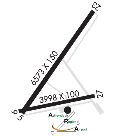
ACTVT HIRL RY 05/23, MIRL RY 09/27, MALSR RY 23, PAPI RY 05, & TWY LGTS - CTAF.
Airport Storage AvailableTie Downs, Hanger
Extra Services AvailableCharter
Wind IndicatorYES - (lighted)
Control TowerNO
CTAF Frequency123.000
Unicom Frequency123.000
Rotating Beacon ColorWG
Segmented CircleNO
Landing FeeYES

Airport Inspection Data

Airport InspectedFEDERAL - performed by FAA AIRPORTS FIELD PERSONNEL
Inspection Date07/25/2023

Airport Services

Type of Fuel AvailableGrade 100LL, JET A (freeze point -40C)
Airframe Repair ServiceMAJOR
Power Plant Repair ServiceMAJOR

Geographic Data

LatitudeN4423.1
LongitudeW07412.4 (ESTIMATED)
Arpt Elevation1662ft (SURVEYED)
Magnetic Variation14W
4 miles NWof SARANAC LAKE
Traffic Pattern Altitude
Sectional ChartMONTREAL

Aircraft Data

Operations (Reported)YearlyAvg. Daily
General Aviation Transient 348010
General Aviation Local 8702
Air Taxi 16144
Commerical 00
Commuter 00
Military 1520
Aircraft based on Field
General Aviation Singles 10
General Aviation Multi 4
Jet Aircraft 0
General Aviation Helicopters 2
Military Aircraft 0
Gliders 0
Ultralights 0

FAA Services

FSS on field NO
FSS tie-in BURLINGTON
FSS Phone 1-800-WX-BRIEF
Who issues Notams SLK
Notam D service at airport YES
ARTCC Name BOSTON

Federal Status

Airport CertificationAIRPORT RECEIVING SCHEDULED AIR CARRIER SERVICE FROM CARRIERS CERTIFICATED BY THE CIVIL AERONAUTICS BOARD; PPR 48 HR FOR UNSKED ACR OPNS WITH MORE THAN 30 PSGR SEATS CALL AMGR 518-891-4600 EXT. 106. INDEX "B" COVERAGE IS PROVIDED.
Aircraft Rescue & Firefighting IndexAIRPORT HAS A CERTIFICATE UNDER CFR PART 139
Airport of EntryNo
Custom Landing RightsYES
Joint Civil/MilitaryNo
Military Landing rightsYES

Federal Agreements

NATIONAL PLAN OF INTEGRATED AIRPORT SYSTEMS (NPIAS)
GRANT AGREEMENTS UNDER FAAP/ADAP/AIP
ASSURANCES PURSUANT TO TITLE VI, CIVIL RIGHTS ACT OF 1964
AGREEMENT UNDER DLAND OR DCLA HAS EXPIRED.

Remarks

TWY B UNAVBL TO ACFT WITH WINGSPAN 79 FT & ABV.
COLD TEMPERATURE AIRPORT. ALTITUDE CORRECTION REQUIRED AT OR BELOW -29C.
FOR CD IF UNA TO CTC ON FREQ, CTC BOSTON ARTCC AT 603-879-6859.
Airport Communications & Frequencies:
CTAF Frequency:
123.000
Unicom Frequency:
123.000
Remarks
  • APCH/DEP SVC PRVDD BY BOSTON ARTCC ON FREQS 120.35/342.25 (ST. ALBANS RCAG).
  • Runway Identifications
    Runway Identification: 05/23
    Length: 6573 ft
    Width: 150 ft
    Surface: ASPHALT-GOOD CONDITION
    Edge lights: High Intensity

    Treatment: GROOVED
    Weight: PCN 64 /F/B/W/T

     Runway: 05   Runway: 23
    Mag heading: 49°Mag heading: 229°
    Rwy Slope: .34% UpRwy Slope: -.34% Down
    Approach: Approach: ILS
    Pattern: Left TrafficPattern: Left Traffic
    Markings: NONPRECISION INSTRUMENTMarkings: PRECISION INSTRUMENT
    Marking Condition: FAIRMarking Condition: FAIR
    Arresting Dev: Arresting Dev:
    Lat & Long: N4422.8  W07412.8Lat. & Long.: N4423.7  W07411.9
    Elev: 1640.0 ft. MSLElev: 1662.5 ft. MSL
    TCH: 35 ft. AGLTCH:
    Visual Glide Path: 3.00 degreesVisual Glide Path:
    Displaced Threshold: NoDisplaced Threshold: No
    Touchdown Zone: YESTouchdown Zone: YES
    Touchdown Elev.: 1653.9 feetTouchdown Elev.: 1662.6 feet
    Visual Glide Slope: 4-Light PAPI on LEFT side of RunwayVisual Glide Slope:
    RVR Equipment: RVR Equipment:
    RVV Equipment: NORVV Equipment: NO
    Approach Lights: Approach Lights: MALSR - 1,400 foot medium intensity approach lighting system with runway alignment indicator lights
    REIL: NOREIL: NO
    Centerline Lights: NOCenterline Lights: NO
    Touchdown lights: NOTouchdown lights: NO
    Runway Category: Runway with a Non-precision Approach having visibility minimums greater than 3/4 mileRunway Category: Precision Instrument Runway
    Declared Distances: TORA:6573' TODA:6573' ASDA:6573' LDA:6573'Declared Distances: TORA:6573' TODA:6573' ASDA:6333' LDA:6333'
    Obstructions: TREESObstructions: TREES
    Marked: NOT Marked/LightedMarked: NOT Marked/Lighted
    Clearance slope: 10:1Clearance slope: 26:1
    Obstruction height: 18 feet AGLObstruction height: 7 feet AGL
    Dist. from runway: 387 feetDist. from runway: 385 feet
    Centerline offset: 387 left of centerlineCenterline offset: 532 feet right of centerline
    Comments: Comments:
    Runway Identification: 09/27
    Length: 3997 ft
    Width: 100 ft
    Surface: ASPHALT-GOOD CONDITION
    Edge lights: Medium Intensity

    Treatment: NONE
    Weight: PCN 61 /F/B/W/T

     Runway: 09   Runway: 27
    Mag heading: 93°Mag heading: 273°
    Rwy Slope: -.01% DownRwy Slope: .01% Up
    Approach: Approach:
    Pattern: Left TrafficPattern: Left Traffic
    Markings: NONSTANDARDMarkings: NONPRECISION INSTRUMENT
    Marking Condition: GOOD; NSTD MKGS; THLD MKGS 400 FT FM RY END.Marking Condition: GOOD
    Arresting Dev: Arresting Dev:
    Lat & Long: N4422.8  W07412.8Lat. & Long.: N4423.0  W07411.9
    Elev: 1638.8 ft. MSLElev: 1638.3 ft. MSL
    TCH: TCH:
    Visual Glide Path: Visual Glide Path:
    Displaced Threshold: NoDisplaced Threshold: 400 feet
    Touchdown Zone: YESTouchdown Zone: YES
    Touchdown Elev.: 1643.5 feetTouchdown Elev.: 1643.5 feet
    Visual Glide Slope: Visual Glide Slope:
    RVR Equipment: RVR Equipment:
    RVV Equipment: NORVV Equipment: NO
    Approach Lights: Approach Lights:
    REIL: NOREIL: NO
    Centerline Lights: NOCenterline Lights: NO
    Touchdown lights: NOTouchdown lights: NO
    Runway Category: Runway with a Non-precision Approach having visibility minimums greater than 3/4 mileRunway Category: Runway with a Visual Approach
    Declared Distances: TORA:3997' TODA:3997' ASDA:3997' LDA:3997'Declared Distances: TORA:3997' TODA:3997' ASDA:3997' LDA:3597'
    Obstructions: TREESObstructions: TREES
    Marked: NOT Marked/LightedMarked: NOT Marked/Lighted
    Clearance slope: Clearance slope: 10:1
    Obstruction height: 27 feet AGLObstruction height: 18 feet AGL
    Dist. from runway: 214 feetDist. from runway: 387 feet
    Centerline offset: 252 left of centerlineCenterline offset: 56 feet left of centerline
    Comments: Comments:
    C:21/P: