Current Weather/Notams (Metars, TAFs, Notams, NWS Forecast, PIREPS, and nearby weather)
Customs Information Send updates to Support@FltPlan.com
Customs Not Available
Database effective 04/18/2024
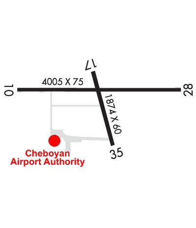
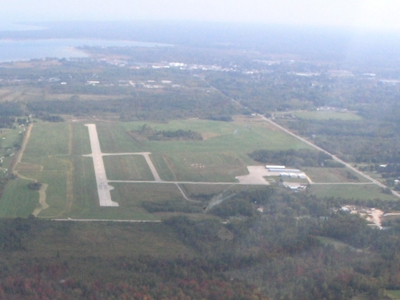
Airport Diagram might not be current. Facility Name: CHEBOYGAN COUNTY City Name: CHEBOYGAN County: CHEBOYGAN State abbrev: MI State Name: MICHIGAN Ownership: PUBLICLY OWNED Use: OPEN TO THE PUBLIC Owner's Name: CHEBOYGAN AIRPORT AUTHORITY Address: 1520 LEVERING RD CHEBOYGAN, MI 49721-9381 Owner's Phone: 231-627-5571 Manager's Name: MICHAEL JERMEAY Address: 1520 LEVERING RD CHEBOYGAN, MI 49721-9381 Phone: 231-627-5571 FAA Region: GREAT LAKES FAA Field Office: DET
Runway Identifications Help
Runway Identification: 10/28 Length: 4004 ftWidth: 75 ftSurface: ASPHALT-GOOD CONDITIONEdge lights: Medium Intensity Treatment: NONE Runway: 10 Runway: 28 Mag heading: 97° Mag heading: 277° Rwy Slope: -.31% Down Rwy Slope: .31% Up Approach: Approach: Pattern: Left Traffic Pattern: Left Traffic Markings: NONPRECISION INSTRUMENT Markings: NONPRECISION INSTRUMENT Marking Condition: GOOD Marking Condition: GOOD Arresting Dev: Arresting Dev: Lat & Long: N4539.3 W08431.6 Lat. & Long.: N4539.3 W08430.7 Elev: 639.5 ft. MSL Elev: 626.9 ft. MSL TCH: 40 ft. AGL TCH: 25 ft. AGL Visual Glide Path: 4.00 degrees Visual Glide Path: 4.00 degrees Displaced Threshold: No Displaced Threshold: No Touchdown Zone: YES Touchdown Zone: YES Touchdown Elev.: 639.7 feet Touchdown Elev.: 637.3 feet Visual Glide Slope: 2-Light PAPI on LEFT side of Runway Visual Glide Slope: 2-Light PAPI on LEFT side of Runway RVR Equipment: RVR Equipment: RVV Equipment: NO RVV Equipment: NO Approach Lights: Approach Lights: REIL: YES REIL: YES Centerline Lights: NO Centerline Lights: NO Touchdown lights: NO Touchdown lights: NO Runway Category: Runway with a Non-precision Approach Runway Category: Runway with a Non-precision Approach Declared Distances: Declared Distances: Obstructions: ROAD Obstructions: TREES Marked: NOT Marked/Lighted Marked: NOT Marked/Lighted Clearance slope: 9:1 Clearance slope: 5:1 Obstruction height: 19 feet AGL Obstruction height: 33 feet AGL Dist. from runway: 380 feet Dist. from runway: 376 feet Centerline offset: 276 right of centerline Centerline offset: 250 feet left of centerline Comments: Comments:
Runway Identification: 17/35 Length: 1874 ftWidth: 60 ftSurface: ASPHALT-GOOD CONDITIONEdge lights: Medium Intensity Treatment: NONE Runway: 17 Runway: 35 Mag heading: 172° Mag heading: 352° Rwy Slope: .13% Up Rwy Slope: -.13% Down Approach: Approach: Pattern: Left Traffic Pattern: Left Traffic Markings: BASIC Markings: BASIC Marking Condition: GOOD Marking Condition: GOOD Arresting Dev: Arresting Dev: Lat & Long: N4539.3 W08431.2 Lat. & Long.: N4539.0 W08431.1 Elev: 633.0 ft. MSL Elev: 635.5 ft. MSL TCH: TCH: Visual Glide Path: Visual Glide Path: Displaced Threshold: No Displaced Threshold: No Touchdown Zone: YES Touchdown Zone: YES Touchdown Elev.: 635.5 feet Touchdown Elev.: 635.5 feet Visual Glide Slope: Visual Glide Slope: RVR Equipment: RVR Equipment: RVV Equipment: NO RVV Equipment: NO Approach Lights: Approach Lights: REIL: NO REIL: NO Centerline Lights: NO Centerline Lights: NO Touchdown lights: NO Touchdown lights: NO Runway Category: Runway with a Visual Approach Runway Category: Runway with a Visual Approach Declared Distances: Declared Distances: Obstructions: Obstructions: TREES Marked: Marked: NOT Marked/Lighted Clearance slope: 20:1 Clearance slope: 14:1 Obstruction height: Obstruction height: 83 feet AGL Dist. from runway: Dist. from runway: 1427 feet Centerline offset: Centerline offset: 248 feet left of centerline Comments: Comments: