Current Weather/Notams (Metars, TAFs, Notams, NWS Forecast, PIREPS, and nearby weather)
Customs Information Send updates to Support@FltPlan.com
Customs Not Available
Database effective 05/16/2024
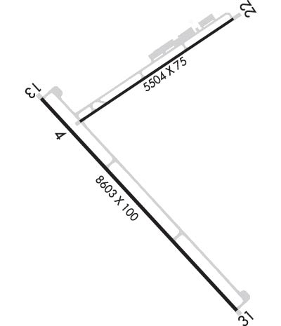
Airport Diagram might not be current. Facility Name: TAOS RGNL City Name: TAOS County: TAOS State abbrev: NM State Name: NEW MEXICO Ownership: PUBLICLY OWNED Use: OPEN TO THE PUBLIC Owner's Name: TOWN OF TAOS Address: 400 CAMINO DE LA PLACITA TAOS, NM 87571 Owner's Phone: 575-751-2000 Manager's Name: KINO CHAVEZ; AIRPORT & FBO MANAGER Address: PO BOX 1636; PHYSICAL ADDRESS 24662 HWY 64, EL PRADO NM 87529 EL PRADO, NM 87529 Phone: 575-737-9790; EMERGENCY PHONE: 575-779-3027 (CELL) FAA Region: SOUTHWEST FAA Field Office: LNM
Runway Identifications Help
Runway Identification: 04/22 Length: 5504 ftWidth: 75 ftSurface: ASPHALT-GOOD CONDITIONEdge lights: Medium Intensity Treatment: POROUS FRICTION COURSEWeight: PCN 4 /F/D/Y/T Runway: 04 Runway: 22 Mag heading: 47° Mag heading: 227° Rwy Slope: .77% Up Rwy Slope: -.77% Down Approach: Approach: Pattern: Left Traffic Pattern: Left Traffic Markings: NONPRECISION INSTRUMENT Markings: BASIC Marking Condition: GOOD Marking Condition: GOOD Arresting Dev: Arresting Dev: Lat & Long: N3627.3 W10540.8 Lat. & Long.: N3627.8 W10539.9 Elev: 7052.4 ft. MSL Elev: 7094.6 ft. MSL TCH: 40 ft. AGL TCH: 40 ft. AGL Visual Glide Path: 3.00 degrees Visual Glide Path: 3.00 degrees Displaced Threshold: No Displaced Threshold: No Touchdown Zone: YES Touchdown Zone: YES Touchdown Elev.: 7069.6 feet Touchdown Elev.: 7094.6 feet Visual Glide Slope: 4-Light PAPI on LEFT side of Runway Visual Glide Slope: 4-Light PAPI on LEFT side of Runway RVR Equipment: RVR Equipment: RVV Equipment: NO RVV Equipment: NO Approach Lights: Approach Lights: REIL: YES REIL: NO Centerline Lights: NO Centerline Lights: NO Touchdown lights: NO Touchdown lights: NO Runway Category: Runway with a Non-precision Approach having visibility minimums greater than 3/4 mile Runway Category: Runway with a Visual Approach Declared Distances: Declared Distances:
Runway Identification: 13/31 Length: 8600 ftWidth: 100 ftSurface: CONCRETE-GOOD CONDITIONEdge lights: Medium Intensity Treatment: GROOVEDWeight: PCN 51 /F/D/X/T Runway: 13 Runway: 31 Mag heading: 128° Mag heading: 308° Rwy Slope: -.26% Down Rwy Slope: .26% Up Approach: Approach: Pattern: Left Traffic Pattern: Left Traffic Markings: PRECISION INSTRUMENT Markings: NONPRECISION INSTRUMENT Marking Condition: GOOD Marking Condition: GOOD Arresting Dev: Arresting Dev: Lat & Long: N3627.4 W10541.0 Lat. & Long.: N3626.3 W10539.8 Elev: 7047.3 ft. MSL Elev: 7024.9 ft. MSL TCH: 37 ft. AGL TCH: 40 ft. AGL Visual Glide Path: 3.00 degrees Visual Glide Path: 3.00 degrees Displaced Threshold: No Displaced Threshold: No Touchdown Zone: YES Touchdown Zone: YES Touchdown Elev.: 7057.0 feet Touchdown Elev.: 7048.6 feet Visual Glide Slope: 4-Light PAPI on LEFT side of Runway Visual Glide Slope: 4-Light PAPI on LEFT side of Runway RVR Equipment: RVR Equipment: RVV Equipment: NO RVV Equipment: NO Approach Lights: Approach Lights: REIL: YES REIL: YES Centerline Lights: NO Centerline Lights: NO Touchdown lights: NO Touchdown lights: NO Runway Category: D Runway Category: Runway with a Visual Approach Declared Distances: Declared Distances: