Current Weather/Notams (Metars, TAFs, Notams, NWS Forecast, PIREPS, and nearby weather)
Customs Information Send updates to Support@FltPlan.com
Customs Not Available
Database effective 04/18/2024
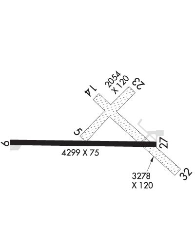
Airport Diagram might not be current.
|
| Facility Name: | BEAVER ISLAND |
| City Name: | BEAVER ISLAND |
| County: | CHARLEVOIX |
| State abbrev: | MI |
| State Name: | MICHIGAN |
| | |
| Ownership: | PUBLICLY OWNED |
| Use: | OPEN TO THE PUBLIC |
| Owner's Name: | ST JAMES & PEAINE TOWNSHIPS |
| Address: | BEAVER ISLAND AIRPORT |
| | BEAVER ISLAND, MI 49782 |
| Owner's Phone: | 231-448-2750 |
| | |
| Manager's Name: | RACHEL TEAGUE |
| Address: | PO BOX 134 |
| | BEAVER ISLAND, MI 49782-0134 |
| Phone: | 231-237-9482; CELL 231-675-5391. |
| | |
| FAA Region: | GREAT LAKES |
| FAA Field Office: | DET |
Runway Identifications
Runway Identification: 05/23Length: 2054 ft
Width: 120 ft
Surface: GRASS-GOOD CONDITION
Edge lights: Treatment: NONE
| | Runway: 05 | | Runway: 23 |
| Mag heading: | 50° | Mag heading: | 230° |
| Rwy Slope: | -.03% Down | Rwy Slope: | .03% Up |
| Approach: | | Approach: | |
| Pattern: | Left Traffic | Pattern: | Left Traffic |
| Markings: | | Markings: | |
| Marking Condition: | 3 FT YELLOW CONES. | Marking Condition: | 3 FT YELLOW CONES; DTHR MKD WITH 3 CONES EACH SIDE. |
| Arresting Dev: | | Arresting Dev: | |
| Lat & Long: | N4541.5 W08534.2 | Lat. & Long.: | N4541.7 W08533.8 |
| Elev: | 665.5 ft. MSL | Elev: | 664.9 ft. MSL |
| TCH: | | TCH: | |
| Visual Glide Path: | | Visual Glide Path: | |
| Displaced Threshold: | No | Displaced Threshold: | 763 feet |
| Touchdown Zone: | YES | Touchdown Zone: | YES |
| Touchdown Elev.: | 665.5 feet | Touchdown Elev.: | 665.5 feet |
| Visual Glide Slope: | | Visual Glide Slope: | |
| RVR Equipment: | | RVR Equipment: | |
| RVV Equipment: | NO | RVV Equipment: | NO |
| Approach Lights: | | Approach Lights: | |
| REIL: | NO | REIL: | NO |
| Centerline Lights: | NO | Centerline Lights: | NO |
| Touchdown lights: | NO | Touchdown lights: | NO |
| Runway Category: | Runway with a Visual Approach | Runway Category: | Runway with a Visual Approach |
| Declared Distances: | | Declared Distances: | |
| Obstructions: | TREES | Obstructions: | TREES |
| Marked: | NOT Marked/Lighted | Marked: | NOT Marked/Lighted |
| Clearance slope: | 15:1 | Clearance slope: | 4:1; APCH RATIO 17:1 TO DTHR. |
| Obstruction height: | 82 feet AGL | Obstruction height: | 49 feet AGL |
| Dist. from runway: | 1238 feet | Dist. from runway: | 230 feet |
| Centerline offset: | | Centerline offset: | 130 feet left of centerline |
| Comments: | | Comments: | |
Runway Identification: 09/27Length: 4299 ft
Width: 75 ft
Surface: ASPHALT-GOOD CONDITION
Edge lights: Medium IntensityTreatment: NONE
| | Runway: 09 | | Runway: 27 |
| Mag heading: | 96° | Mag heading: | 276° |
| Rwy Slope: | -.06% Down | Rwy Slope: | .06% Up |
| Approach: | | Approach: | |
| Pattern: | Left Traffic | Pattern: | Left Traffic |
| Markings: | NONPRECISION INSTRUMENT | Markings: | NONPRECISION INSTRUMENT |
| Marking Condition: | FAIR | Marking Condition: | FAIR |
| Arresting Dev: | | Arresting Dev: | |
| Lat & Long: | N4541.5 W08534.7 | Lat. & Long.: | N4541.5 W08533.7 |
| Elev: | 669.7 ft. MSL | Elev: | 667.3 ft. MSL |
| TCH: | 24 ft. AGL | TCH: | 40 ft. AGL |
| Visual Glide Path: | 3.00 degrees | Visual Glide Path: | 4.00 degrees |
| Displaced Threshold: | No | Displaced Threshold: | No |
| Touchdown Zone: | YES | Touchdown Zone: | YES |
| Touchdown Elev.: | 669.8 feet | Touchdown Elev.: | 668.2 feet |
| Visual Glide Slope: | 4-Light PAPI on LEFT side of Runway | Visual Glide Slope: | 4-Light PAPI on LEFT side of Runway |
| RVR Equipment: | | RVR Equipment: | |
| RVV Equipment: | NO | RVV Equipment: | NO |
| Approach Lights: | | Approach Lights: | |
| REIL: | YES | REIL: | YES |
| Centerline Lights: | NO | Centerline Lights: | NO |
| Touchdown lights: | NO | Touchdown lights: | NO |
| Runway Category: | Runway with a Non-precision Approach | Runway Category: | Runway with a Non-precision Approach |
| Declared Distances: | | Declared Distances: | |
| Obstructions: | | Obstructions: | TREE |
| Marked: | | Marked: | NOT Marked/Lighted |
| Clearance slope: | 20:1 | Clearance slope: | 12:1 |
| Obstruction height: | | Obstruction height: | 67 feet AGL |
| Dist. from runway: | | Dist. from runway: | 1010 feet |
| Centerline offset: | | Centerline offset: | 330 feet right of centerline |
| Comments: | | Comments: | |
Runway Identification: 14/32Length: 3278 ft
Width: 120 ft
Surface: GRASS-GOOD CONDITION
Edge lights: Treatment: NONE
| | Runway: 14 | | Runway: 32 |
| Mag heading: | 138° | Mag heading: | 318° |
| Rwy Slope: | .05% Up | Rwy Slope: | -.05% Down |
| Approach: | | Approach: | |
| Pattern: | Left Traffic | Pattern: | Left Traffic |
| Markings: | | Markings: | |
| Marking Condition: | 3 FT YELLOW CONES; DTHR MKD WITH 3 CONES EACH SIDE. | Marking Condition: | 3 FT YELLOW CONES; DTHR MKD WITH 3 CONES EACH SIDE. |
| Arresting Dev: | | Arresting Dev: | |
| Lat & Long: | N4541.7 W08534.1 | Lat. & Long.: | N4541.3 W08533.5 |
| Elev: | 666.3 ft. MSL | Elev: | 668.0 ft. MSL |
| TCH: | | TCH: | |
| Visual Glide Path: | | Visual Glide Path: | |
| Displaced Threshold: | 522 feet | Displaced Threshold: | 571 feet |
| Touchdown Zone: | YES | Touchdown Zone: | YES |
| Touchdown Elev.: | 668.0 feet | Touchdown Elev.: | 666.3 feet |
| Visual Glide Slope: | | Visual Glide Slope: | |
| RVR Equipment: | | RVR Equipment: | |
| RVV Equipment: | NO | RVV Equipment: | NO |
| Approach Lights: | | Approach Lights: | |
| REIL: | NO | REIL: | NO |
| Centerline Lights: | NO | Centerline Lights: | NO |
| Touchdown lights: | NO | Touchdown lights: | NO |
| Runway Category: | Runway with a Visual Approach | Runway Category: | Runway with a Visual Approach |
| Declared Distances: | | Declared Distances: | |
| Obstructions: | TREES | Obstructions: | ROAD |
| Marked: | NOT Marked/Lighted | Marked: | NOT Marked/Lighted |
| Clearance slope: | APCH RATIO 6:1 TO DTHR. | Clearance slope: | 5:1; APCH RATIO 13:1 TO DTHR. |
| Obstruction height: | 70 feet AGL | Obstruction height: | 15 feet AGL |
| Dist. from runway: | 0 feet | Dist. from runway: | 75 feet |
| Centerline offset: | 125 left of centerline | Centerline offset: | 133 feet right of centerline |
| Comments: | | Comments: | |

