Current Weather/Notams (Metars, TAFs, Notams, NWS Forecast, PIREPS, and nearby weather)
Customs Information Send updates to Support@FltPlan.com
Customs Not Available
Database effective 05/16/2024
Airport Diagram might not be current.
|
| Facility Name: | BIG SANDY RGNL |
| City Name: | PRESTONSBURG |
| County: | MARTIN |
| State abbrev: | KY |
| State Name: | KENTUCKY |
| | |
| Ownership: | PUBLICLY OWNED |
| Use: | OPEN TO THE PUBLIC |
| Owner's Name: | BIG SANDY REGIONAL AIRPORT BD |
| Address: | 2960 AIRPORT ROAD |
| | DEBORD, KY 41214 |
| Owner's Phone: | (606) 369-6818 |
| | |
| Manager's Name: | GARY COX |
| Address: | 2960 AIRPORT ROAD |
| | DEBORD, KY 41214 |
| Phone: | 606-298-5930; AFT HR SVC - 606-371-3793. |
| | |
| FAA Region: | SOUTHERN |
| FAA Field Office: | MEM |
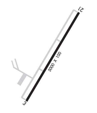
Runway Identifications
Runway Identification: 03/21Length: 5051 ft
Width: 100 ft
Surface: ASPHALT
Edge lights: Medium IntensityTreatment: NONE
Weight: PCN 7 /F/D/X/T
| | Runway: 03 | | Runway: 21 |
| Mag heading: | 36° | Mag heading: | 216° |
| Rwy Slope: | 1.02% Up | Rwy Slope: | -1.02% Down |
| Approach: | | Approach: | |
| Pattern: | Left Traffic | Pattern: | Left Traffic |
| Markings: | NONPRECISION INSTRUMENT | Markings: | NONPRECISION INSTRUMENT |
| Marking Condition: | GOOD | Marking Condition: | GOOD |
| Arresting Dev: | | Arresting Dev: | |
| Lat & Long: | N3744.7 W08238.5 | Lat. & Long.: | N3745.4 W08237.9 |
| Elev: | 1169.6 ft. MSL | Elev: | 1221.0 ft. MSL |
| TCH: | 38 ft. AGL | TCH: | 25 ft. AGL |
| Visual Glide Path: | 4.00 degrees | Visual Glide Path: | 3.00 degrees |
| Displaced Threshold: | No | Displaced Threshold: | No |
| Touchdown Zone: | YES | Touchdown Zone: | YES |
| Touchdown Elev.: | 1210.0 feet | Touchdown Elev.: | 1221.5 feet |
| Visual Glide Slope: | 2-Light PAPI on LEFT side of Runway; PAPI UNUSBL BYD 6 DEGS RIGHT OF CNTRLN. | Visual Glide Slope: | 2-Light PAPI on LEFT side of Runway |
| RVR Equipment: | | RVR Equipment: | |
| RVV Equipment: | NO | RVV Equipment: | NO |
| Approach Lights: | | Approach Lights: | |
| REIL: | YES | REIL: | YES |
| Centerline Lights: | NO | Centerline Lights: | NO |
| Touchdown lights: | NO | Touchdown lights: | NO |
| Runway Category: | Runway with a Non-precision Approach having visibility minimums greater than 3/4 mile | Runway Category: | Runway with a Non-precision Approach having visibility minimums greater than 3/4 mile |
| Declared Distances: | | Declared Distances: | |
| Obstructions: | POLE | Obstructions: | TREE |
| Marked: | NOT Marked/Lighted | Marked: | NOT Marked/Lighted |
| Clearance slope: | 16:1 | Clearance slope: | 14:1 |
| Obstruction height: | 72 feet AGL | Obstruction height: | 8 feet AGL |
| Dist. from runway: | 1391 feet | Dist. from runway: | 316 feet |
| Centerline offset: | 191 left of centerline | Centerline offset: | 218 feet left of centerline |
| Comments: | | Comments: | |

