Current Weather/Notams (Metars, TAFs, Notams, NWS Forecast, PIREPS, and nearby weather)
Customs Information Send updates to Support@FltPlan.com
Customs Not Available
Database effective 04/18/2024
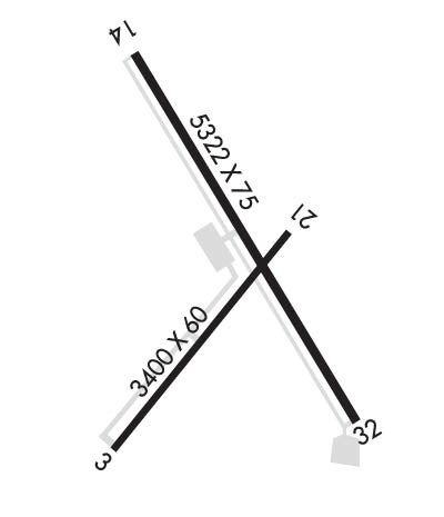
Airport Diagram might not be current. Facility Name: ST JOHNS INDUSTRIAL AIR PARK City Name: ST JOHNS County: APACHE State abbrev: AZ State Name: ARIZONA Ownership: PUBLICLY OWNED Use: OPEN TO THE PUBLIC Owner's Name: CITY OF ST. JOHNS Address: P.O. BOX 455 ST. JOHNS, AZ 85936 Owner's Phone: 928-337-4517 Manager's Name: GARY LISTON Address: P.O. BOX 455 ST. JOHNS, AZ 85936 Phone: 928-337-4254; EMERGENCY PHONE: 928-245-0391 FAA Region: WESTERN-PACIFIC FAA Field Office: PHX
Runway Identifications Help
Runway Identification: 03/21 Length: 3400 ftWidth: 60 ftSurface: ASPHALT-GOOD CONDITIONEdge lights: Medium Intensity Treatment: NONE Runway: 03 Runway: 21 Mag heading: 25° Mag heading: 205° Rwy Slope: .23% Up Rwy Slope: -.23% Down Approach: Approach: Pattern: Left Traffic Pattern: Left Traffic Markings: BASIC Markings: BASIC Marking Condition: POOR Marking Condition: POOR Arresting Dev: Arresting Dev: Lat & Long: N3430.8 W10923.0 Lat. & Long.: N3431.2 W10922.6 Elev: 5727.0 ft. MSL Elev: 5734.7 ft. MSL TCH: TCH: Visual Glide Path: Visual Glide Path: Displaced Threshold: 190 feet Displaced Threshold: No Touchdown Zone: YES Touchdown Zone: YES Touchdown Elev.: 5735.7 feet Touchdown Elev.: 5735.7 feet Visual Glide Slope: Visual Glide Slope: RVR Equipment: RVR Equipment: RVV Equipment: NO RVV Equipment: NO Approach Lights: Approach Lights: REIL: NO REIL: NO Centerline Lights: NO Centerline Lights: NO Touchdown lights: NO Touchdown lights: NO Runway Category: Runway with a Visual Approach Runway Category: Runway with a Visual Approach Declared Distances: Declared Distances: Obstructions: TREE Obstructions: Marked: NOT Marked/Lighted Marked: Clearance slope: 6:1; APCH RATIO 16:1 TO DSPLCD THLD BASED ON 60' TREE 1018 FT. FROM DISPLACED THRESHOLD, ON CENTERLINE. Clearance slope: 50:1 Obstruction height: 39 feet AGL Obstruction height: Dist. from runway: 440 feet Dist. from runway: Centerline offset: 75 left of centerline Centerline offset: Comments: Comments:
Runway Identification: 14/32 Length: 5322 ftWidth: 75 ftSurface: ASPHALT-GOOD CONDITIONEdge lights: Medium Intensity Treatment: NONE Runway: 14 Runway: 32 Mag heading: 136° Mag heading: 316° Rwy Slope: .05% Up Rwy Slope: -.05% Down Approach: Approach: Pattern: Left Traffic Pattern: Left Traffic Markings: NONPRECISION INSTRUMENT Markings: NONPRECISION INSTRUMENT Marking Condition: POOR Marking Condition: POOR Arresting Dev: Arresting Dev: Lat & Long: N3431.6 W10923.0 Lat. & Long.: N3430.8 W10922.4 Elev: 5734.1 ft. MSL Elev: 5736.5 ft. MSL TCH: 40 ft. AGL TCH: 40 ft. AGL Visual Glide Path: 3.00 degrees Visual Glide Path: 3.00 degrees Displaced Threshold: No Displaced Threshold: 92 feet Touchdown Zone: YES Touchdown Zone: YES Touchdown Elev.: 5736.0 feet Touchdown Elev.: 5736.5 feet Visual Glide Slope: 2-Light PAPI on LEFT side of Runway; PAPI OTS INDEFLY. Visual Glide Slope: 2-Light PAPI on RIGHT side of Runway; PAPI OTS INDEFLY. RVR Equipment: RVR Equipment: RVV Equipment: NO RVV Equipment: NO Approach Lights: Approach Lights: REIL: YES REIL: YES Centerline Lights: NO Centerline Lights: NO Touchdown lights: NO Touchdown lights: NO Runway Category: Runway with a Non-precision Approach Runway Category: Runway with a Non-precision Approach Declared Distances: Declared Distances: Obstructions: CONTROLLING OBJECT IS OBSTRUCTION LIGHTS ON POLE. Obstructions: POLE Marked: NOT Marked/Lighted Marked: LIGHTED Clearance slope: 20:1 Clearance slope: 10:1; APCH RATIO 27:1 AT DSPLCD THLD. Obstruction height: Obstruction height: 17 feet AGL Dist. from runway: Dist. from runway: 375 feet Centerline offset: Centerline offset: 135 feet right of centerline Comments: Comments: RY 32 0 FT-12 FT FENCE 0 FT-200 FT FM THRLD 135 FT 150 FT R OF CNTRLN. +10' ROAD 0'-150' ACROSS APPROACH AREA.