Current Weather/Notams (Metars, TAFs, Notams, NWS Forecast, PIREPS, and nearby weather)
Customs Information Send updates to Support@FltPlan.com
Customs Not Available
Database effective 04/18/2024
Airport Diagram might not be current.
|
| Facility Name: | ROCKINGHAM COUNTY NC SHILOH |
| City Name: | REIDSVILLE |
| County: | ROCKINGHAM |
| State abbrev: | NC |
| State Name: | NORTH CAROLINA |
| | |
| Ownership: | PUBLICLY OWNED |
| Use: | OPEN TO THE PUBLIC |
| Owner's Name: | ROCKINGHAM COUNTY |
| Address: | 2691 SETTLE BRIDGE ROAD |
| | STONEVILLE, NC 27048 |
| Owner's Phone: | 336-573-3115 |
| | |
| Manager's Name: | MIKE BROOKS; MANAGER CELL 336-613-7671. |
| Address: | 2691 SETTLE BRIDGE ROAD |
| | STONEVILLE, NC 27048 |
| Phone: | 336-573-3115; FAX 336-573-9415. |
| | |
| FAA Region: | SOUTHERN |
| FAA Field Office: | MEM |
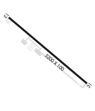
Runway Identifications
Runway Identification: 13/31Length: 5200 ft
Width: 100 ft
Surface: ASPHALT-GOOD CONDITION
Edge lights: High IntensityTreatment: NONE
| | Runway: 13 | | Runway: 31 |
| Mag heading: | 132° | Mag heading: | 312° |
| Rwy Slope: | -.49% Down | Rwy Slope: | .49% Up |
| Approach: | | Approach: | SDF |
| Pattern: | Left Traffic | Pattern: | Left Traffic |
| Markings: | NONPRECISION INSTRUMENT | Markings: | NONPRECISION INSTRUMENT |
| Marking Condition: | GOOD | Marking Condition: | GOOD |
| Arresting Dev: | | Arresting Dev: | |
| Lat & Long: | N3626.5 W07951.5 | Lat. & Long.: | N3626.0 W07950.6 |
| Elev: | 693.5 ft. MSL | Elev: | 667.9 ft. MSL |
| TCH: | 45 ft. AGL | TCH: | 38 ft. AGL |
| Visual Glide Path: | 3.70 degrees | Visual Glide Path: | 3.70 degrees |
| Displaced Threshold: | 500 feet | Displaced Threshold: | No |
| Touchdown Zone: | YES | Touchdown Zone: | YES |
| Touchdown Elev.: | 686.3 feet | Touchdown Elev.: | 667.9 feet |
| Visual Glide Slope: | 4-Light PAPI on LEFT side of Runway | Visual Glide Slope: | 4-Light PAPI on LEFT side of Runway |
| RVR Equipment: | | RVR Equipment: | |
| RVV Equipment: | NO | RVV Equipment: | NO |
| Approach Lights: | | Approach Lights: | |
| REIL: | YES | REIL: | YES |
| Centerline Lights: | NO | Centerline Lights: | NO |
| Touchdown lights: | NO | Touchdown lights: | NO |
| Runway Category: | Runway with a Non-precision Approach having visibility minimums greater than 3/4 mile | Runway Category: | Runway with a Non-precision Approach having visibility minimums greater than 3/4 mile |
| Declared Distances: | | Declared Distances: | |
| Obstructions: | TREES | Obstructions: | TREES |
| Marked: | NOT Marked/Lighted | Marked: | NOT Marked/Lighted |
| Clearance slope: | 5:1; APCH RATIO 10:1 AT DSPLCD THR; DUE TO 89 FT TREES 1156 FT FROM DSPLCD THR 318 FT RIGHT OF CNTRLN. | Clearance slope: | 12:1 |
| Obstruction height: | 83 feet AGL | Obstruction height: | 55 feet AGL |
| Dist. from runway: | 671 feet | Dist. from runway: | 893 feet |
| Centerline offset: | 320 right of centerline | Centerline offset: | 211 feet right of centerline |
| Comments: | 5 FT GND 0-200 FT FROM THR 150 FT RIGHT OF CNTRLN. | Comments: | |

