Click here for more info on on SMS!

KSHV

SHREVEPORT RGNL
SHREVEPORT
LA
Time Zone: Central
Lat: N 3226.8
Long: W 09349.6
Elev: 258
Var: -02
Longest Runway: 8348
Clr Del: 124.65
Dept. ATIS: 128.45
Arr. ATIS: 128.45
Ground: 121.17
Tower: 121.4

FBO & Flight Services info for KSHV

FBOs: Update your Fuel Prices
Land at any FBO in our growing worldwide network and you'll receive a warm, friendly Signature greeting. Consistent, exceptional service. Line support that's expert, safe and ready on the ramp. Clean, comfortable, well-furnished facilities. Service professionals who go the extra mile for your passengers and crew. Competitive pricing in every market.
Ph: 318-636-1000 Fax: 318-636-9788 Freq: 130.07WebsiteE-Mail
                          
Service
Jet
100LL
SAF
MoGas
Fuel Avail: JET-A + FSII ADDED FS $7.36
Full6.447.63    Last Update: 04/22/2024 15:26

Self        
Misc. Info: VOLUME DISCOUNTSAddress: 6209 INTERSTATE DR.,   SHREVEPORT, LA 71109

ASOSPh: 318-636-5767
-
-
 
If you are an FBO, call 1-203-262-1700 to update your info or email: FltPlan.Advertising@garmin.com
Advertise your FBO on FltPlan.com

Runway & Approach Info for KSHV
Rwy
Length
Land Dist**
Approach*
  Rwy
Length
Land Dist**
Approach*
06
7003x150  7003'          
LOC/DME
 109.10 - 058°  
  
24
  7003x150  7003'          
 
14
8348x200  8348'          
ILS/DME
 110.70 - 140°  
  
32
  8348x200  7975'          
ILS
 110.30 - 320°  
 * only ILS, LOC, LDA, and SDF approaches to a specific runway are shown
** For any Declared Landing Distance Available, please see A/FD or Approach plates
Runway Weight Capability (lbs.) Help
Runway IDSingle WheelDouble WheelDouble Tandem WheelDual Double Wheel
06/24120,000218,000370,000N/A
14/32120,000218,000370,000N/A
These numbers are Advisory and are not limits.   The Airport Manager should have more accurate Weight Limits
Approach Charts
Approaches    
Current Weather/Notams
Customs Information Send updates to Support@FltPlan.com
Phone 318-635-7873
Fax 318-635-7455

Comments Mon-Fri 0800-1700 *2 hrs advance notice required *Call prior to 1430 on preceding weekday.
Database effective 05/16/2024
Airport Diagram of KSHV
Airport Diagram might not be current.

Facility Name: SHREVEPORT RGNL
City Name: SHREVEPORT
County: CADDO
State abbrev: LA
State Name: LOUISIANA
   
Ownership: PUBLICLY OWNED
Use: OPEN TO THE PUBLIC
Owner's Name: CITY OF SHREVEPORT
Address: 505 TRAVIS STREET
 SHREVEPORT, LA 71101
Owner's Phone: 318-673-5050
  
Manager's Name: LARRY BLACKWELL
Address: 5103 HOLLYWOOD AVE SUITE 300
 SHREVEPORT, LA 71109
Phone: 318-673-5370
   
FAA Region: SOUTHWEST
FAA Field Office: LNM
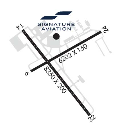
2006 Earthcrawl Photography www.earthcrawl.com


Click here for full scale & interactive Sectional view of KSHV


Sunrise / Sunset times for SHREVEPORT RGNL

DateSunriseSunset
04/22/24 Monday6:3719:51
04/23/24 Tuesday6:3619:51
04/24/24 Wednesday6:3519:52
04/25/24 Thursday6:3419:53
04/26/24 Friday6:3319:54
04/27/24 Saturday6:3219:54
04/28/24 Sunday6:3119:55
04/29/24 Monday6:3019:56
04/30/24 Tuesday6:2919:56
05/01/24 Wednesday6:2819:57
05/02/24 Thursday6:2719:58
05/03/24 Friday6:2619:59
05/04/24 Saturday6:2519:59
05/05/24 Sunday6:2420:00

Airport Facilities

Airport Attendance ScheduleCONTINUOUS
Airport Status OPERATIONAL (This Status can change at any time - please check NOTAMS)
Airport Lighting ScheduleSS-SR
Airport Storage AvailableTie Downs, Hanger
Extra Services AvailableAir Freight, Avionics, Cargo Handling, Charter
Wind IndicatorYES - (lighted)
Control TowerYES
CTAF Frequency
Unicom Frequency122.950
Rotating Beacon ColorWG
Segmented CircleNO
Landing FeeNO; LNDG FEE FOR ALL COMMERCIAL TFC.

Airport Inspection Data

Airport InspectedFEDERAL - performed by FAA AIRPORTS FIELD PERSONNEL
Inspection Date02/22/2024

Airport Services

Type of Fuel AvailableGrade 100LL, JET A (freeze point -40C)
Airframe Repair ServiceMAJOR
Power Plant Repair ServiceMAJOR

Geographic Data

LatitudeN3226.8
LongitudeW09349.6 (ESTIMATED)
Arpt Elevation257ft (SURVEYED)
Magnetic Variation02E
4 miles SWof SHREVEPORT
Traffic Pattern Altitude
Sectional ChartMEMPHIS

Aircraft Data

Operations (Reported)YearlyAvg. Daily
General Aviation Transient 938026
General Aviation Local 22296
Air Taxi 738020
Commerical 1101930
Commuter 00
Military 16515
Aircraft based on Field
General Aviation Singles 18
General Aviation Multi 12
Jet Aircraft 20
General Aviation Helicopters 1
Military Aircraft 0
Gliders 0
Ultralights 0

FAA Services

FSS on field NO
FSS tie-in DE RIDDER
FSS Phone 1-800-WX-BRIEF
Who issues Notams SHV
Notam D service at airport YES
ARTCC Name FORT WORTH

Federal Status

Airport CertificationAIRPORT RECEIVING SCHEDULED AIR CARRIER SERVICE FROM CARRIERS CERTIFICATED BY THE CIVIL AERONAUTICS BOARD
Aircraft Rescue & Firefighting IndexAIRPORT HAS A CERTIFICATE UNDER CFR PART 139
Airport of EntryNo
Custom Landing RightsYES
Joint Civil/MilitaryNo
Military Landing rightsYES

Federal Agreements

NATIONAL PLAN OF INTEGRATED AIRPORT SYSTEMS (NPIAS)
GRANT AGREEMENTS UNDER FAAP/ADAP/AIP
ASSURANCES PURSUANT TO TITLE VI, CIVIL RIGHTS ACT OF 1964

Remarks

FLIGHT NOTIFICATION SERVICE (ADCUS) AVBL MON-FRI 0800-1700; OTHER TIMES BY APPOINTMENT CALL 318-635-7873 OR 800-973-2867.
BIRD ACTIVITY INVOF ARPT.
RWY 06/2 4 PCR VALUE 542 F/B/X/T
RWY 14/3 2 PCR VALUE 542 F/B/X/T
Airport Communications & Frequencies:
ATIS Frequencies:   Hours(local) of Operation: CONTINUOUS
128.45
SHREVEPORT Tower Frequencies:   Hours(local) of operation: CONTINUOUS   
121.4
236.775
SHREVEPORT Ground Frequencies:
121.175
236.775
Clearance Delivery Frequencies:
124.65
Emergency Frequencies:
121.5
243.0
Unicom Frequency:
122.950
SHREVEPORT Primary Approach Frequencies:  
119.9
335.55
SHREVEPORT Primary Departure Frequencies:  
119.9
335.55
Runway Identifications
Runway Identification: 06/24
Length: 7003 ft
Width: 150 ft
Surface: ASPHALT
Edge lights: Medium Intensity

Treatment: GROOVED

 Runway: 06   Runway: 24
Mag heading: 59°Mag heading: 239°
Rwy Slope: -.14% DownRwy Slope: .14% Up
Approach: LOC/DMEApproach:
Pattern: Left TrafficPattern: Left Traffic
Markings: NONPRECISION INSTRUMENTMarkings: NONPRECISION INSTRUMENT
Marking Condition: GOODMarking Condition: GOOD
Arresting Dev: Arresting Dev:
Lat & Long: N3226.6  W09350.1Lat. & Long.: N3227.2  W09348.9
Elev: 238.3 ft. MSLElev: 228.4 ft. MSL
TCH: 50 ft. AGLTCH: 50 ft. AGL
Visual Glide Path: 3.00 degreesVisual Glide Path: 3.00 degrees
Displaced Threshold: NoDisplaced Threshold: No
Touchdown Zone: YESTouchdown Zone: YES
Touchdown Elev.: 238.3 feetTouchdown Elev.: 237.0 feet
Visual Glide Slope: 4-Light PAPI on LEFT side of RunwayVisual Glide Slope: 4-Light PAPI on RIGHT side of Runway
RVR Equipment: RVR Equipment:
RVV Equipment: NORVV Equipment: NO
Approach Lights: Approach Lights:
REIL: YESREIL: YES
Centerline Lights: NOCenterline Lights: NO
Touchdown lights: NOTouchdown lights: NO
Runway Category: Runway with a Non-precision Approach having visibility minimums greater than 3/4 mileRunway Category: Runway with a Non-precision Approach having visibility minimums greater than 3/4 mile
Declared Distances: TORA:7003' TODA:7003' ASDA:7003' LDA:7003'Declared Distances: TORA:7003' TODA:7003' ASDA:7003' LDA:7003'
Obstructions: TREESObstructions: TREES
Marked: NOT Marked/LightedMarked: NOT Marked/Lighted
Clearance slope: 23:1Clearance slope: 32:1
Obstruction height: 77 feet AGLObstruction height: 111 feet AGL
Dist. from runway: 2000 feetDist. from runway: 3800 feet
Centerline offset: 300 right of centerlineCenterline offset:
Comments: Comments:
Runway Identification: 14/32
Length: 8348 ft
Width: 200 ft
Surface: ASPHALT
Edge lights: High Intensity

Treatment: GROOVED

 Runway: 14   Runway: 32
Mag heading: 141°Mag heading: 321°
Rwy Slope: -.43% DownRwy Slope: .43% Up
Approach: ILS/DMEApproach: ILS
Pattern: Left TrafficPattern: Left Traffic
Markings: PRECISION INSTRUMENTMarkings: PRECISION INSTRUMENT
Marking Condition: GOODMarking Condition: GOOD
Arresting Dev: Arresting Dev:
Lat & Long: N3227.2  W09350.1Lat. & Long.: N3226.1  W09349.1
Elev: 257.6 ft. MSLElev: 222.1 ft. MSL
TCH: 50 ft. AGLTCH:
Visual Glide Path: 3.00 degreesVisual Glide Path:
Displaced Threshold: NoDisplaced Threshold: 373 feet
Touchdown Zone: YESTouchdown Zone: YES
Touchdown Elev.: 257.6 feetTouchdown Elev.: 221.9 feet
Visual Glide Slope: 4-Light PAPI on RIGHT side of RunwayVisual Glide Slope:
RVR Equipment: TOUCHDOWN-MIDFIELD-ROLLOUTRVR Equipment: TOUCHDOWN-MIDFIELD-ROLLOUT
RVV Equipment: NORVV Equipment: NO
Approach Lights: ALSF2 - standard 2,400 foot high intensity approach lighting system with sequenced flashers, Category II or IIIApproach Lights: MALSR - 1,400 foot medium intensity approach lighting system with runway alignment indicator lights
REIL: NOREIL: NO
Centerline Lights: YESCenterline Lights: YES
Touchdown lights: YESTouchdown lights: NO
Runway Category: Precision Instrument RunwayRunway Category: Precision Instrument Runway
Declared Distances: TORA:8348' TODA:8348' ASDA:8118' LDA:8118'Declared Distances: TORA:8348' TODA:8348' ASDA:8348' LDA:7975'
Obstructions: Obstructions: RR
Marked: Marked: NOT Marked/Lighted
Clearance slope: 50:1Clearance slope: 22:1; APCH RATIO 40:1 FM DSPLCD THR.
Obstruction height: Obstruction height: 32 feet AGL
Dist. from runway: Dist. from runway: 920 feet
Centerline offset: Centerline offset: 600 feet right of centerline
Comments: Comments:
C:88/P: