Click here for more info on on SMS!

KSHL

SHELDON MUNI
SHELDON
IA
Time Zone: Central
Lat: N 4312.5
Long: W 09550.0
Elev: 1419
Var: -05
Longest Runway: 4199
AWOS: 119.77
CTAF: 122.8

FBO & Flight Services info for KSHL

FBOs: Update your Fuel Prices

MIDWEST FLYING SVPh: 712-324-4005 Fax: 712-324-4507 Freq: 122.8
Service
Jet
100LL
SAF
MoGas
Fuel Avail: PRIST PREMIXED
Full5.345.75    Caution: Fuel prices have not been updated in 36 days.
Last Update: 03/11/2024 12:15

Self5.345.75    
 Address: 3020 NORTHWEST BLVD,   SHELDON, IA 51201
AWOSPh: 712-324-5159
-
Freq: 119.77  
If you are an FBO, call 1-203-262-1700 to update your info or email: FltPlan.Advertising@garmin.com
Advertise your FBO on FltPlan.com

Runway & Approach Info for KSHL
Rwy
Length
Land Dist**
Approach*
  Rwy
Length
Land Dist**
Approach*
15
4199x75  4199'          
 
  
33
  4199x75  4199'          
 
 * only ILS, LOC, LDA, and SDF approaches to a specific runway are shown
** For any Declared Landing Distance Available, please see A/FD or Approach plates
Runway Weight Capability (lbs.) Help
Runway IDSingle WheelDouble WheelDouble Tandem WheelDual Double Wheel
15/3328,000N/AN/AN/A
These numbers are Advisory and are not limits.   The Airport Manager should have more accurate Weight Limits
Approach Charts
Approaches    
Current Weather/Notams
Customs Information Send updates to Support@FltPlan.com
Customs Not Available
Database effective 04/18/2024
Airport Diagram of KSHL
Airport Diagram might not be current.

Facility Name: SHELDON RGNL
City Name: SHELDON
County: O BRIEN
State abbrev: IA
State Name: IOWA
   
Ownership: PUBLICLY OWNED
Use: OPEN TO THE PUBLIC
Owner's Name: CITY OF SHELDON
Address: 416 9TH ST BOX 276
 SHELDON, IA 51201
Owner's Phone: 712-324-4651
  
Manager's Name: LYLE VUST
Address: 3020 NORTHWEST BOULEVARD
 SHELDON, IA 51201-7508
Phone: 712-324-4005
   
FAA Region: CENTRAL
FAA Field Office: NONE


Sunrise / Sunset times for SHELDON RGNL

DateSunriseSunset
04/15/24 Monday6:4020:07
04/16/24 Tuesday6:3820:08
04/17/24 Wednesday6:3720:09
04/18/24 Thursday6:3520:11
04/19/24 Friday6:3320:12
04/20/24 Saturday6:3220:13
04/21/24 Sunday6:3020:14
04/22/24 Monday6:2920:15
04/23/24 Tuesday6:2720:16
04/24/24 Wednesday6:2620:18
04/25/24 Thursday6:2420:19
04/26/24 Friday6:2320:20
04/27/24 Saturday6:2120:21
04/28/24 Sunday6:2020:22

Airport Facilities

Airport Attendance ScheduleMON - FRI 0730 - 1700, SAT - SUN ON CALL; FOR SERVICE AFTER HRS CALL 712-324-4005 OR 324-1900.
Airport Status OPERATIONAL (This Status can change at any time - please check NOTAMS)
Airport Lighting ScheduleACTVT MIRL RY 15/33; PAPI AND REIL RYS 15 & 33 - CTAF.
Airport Storage AvailableTie Downs, Hanger
Extra Services AvailableCharter, Flight Instruction, Aircraft Rental, Aircraft Sales
Wind IndicatorYES - (lighted)
Control TowerNO
CTAF Frequency122.800
Unicom Frequency122.800
Rotating Beacon ColorWG
Segmented CircleNO
Landing FeeNO

Airport Inspection Data

Airport InspectedSTATE - performed by STATE AERONAUTICAL PERSONNEL
Inspection Date06/21/2023

Airport Services

Type of Fuel AvailableGrade 100LL, JET A (freeze point -40C)
Airframe Repair ServiceMAJOR
Power Plant Repair ServiceMAJOR

Geographic Data

LatitudeN4312.5
LongitudeW09550.0 (ESTIMATED)
Arpt Elevation1419ft (SURVEYED)
Magnetic Variation05E
2 miles NEof SHELDON
Traffic Pattern Altitude
Sectional ChartOMAHA

Aircraft Data

Operations (Reported)YearlyAvg. Daily
General Aviation Transient 18885
General Aviation Local 27538
Air Taxi 8242
Commerical 00
Commuter 00
Military 350
Aircraft based on Field
General Aviation Singles 15
General Aviation Multi 4
Jet Aircraft 1
General Aviation Helicopters 0
Military Aircraft 0
Gliders 0
Ultralights 0

FAA Services

FSS on field NO
FSS tie-in FORT DODGE
FSS Phone 1-800-WX-BRIEF
Who issues Notams SHL
Notam D service at airport YES
ARTCC Name MINNEAPOLIS

Federal Status

Airport Certification
Aircraft Rescue & Firefighting IndexNone
Airport of EntryNo
Custom Landing RightsNo
Joint Civil/MilitaryNo
Military Landing rightsYES

Federal Agreements

NATIONAL PLAN OF INTEGRATED AIRPORT SYSTEMS (NPIAS)
GRANT AGREEMENTS UNDER FAAP/ADAP/AIP
ASSURANCES PURSUANT TO TITLE VI, CIVIL RIGHTS ACT OF 1964

Remarks

RY 33 IS CALM WIND RY.
FOR CD CTC MINNEAPOLIS ARTCC AT 651-463-5588.
Airport Communications & Frequencies:
CTAF Frequency:
122.800
Unicom Frequency:
122.800
Remarks
  • COMMUNICATIONS PRVDD BY FORT DODGE RADIO ON FREQ 122.5 (SPENCER RCO).
  • APCH/DEP SVC PRVDD BY MINNEAPOLIS ARTCC (ZMP) ON FREQ 125.025/235.625 (SIOUX CITY RCAG).
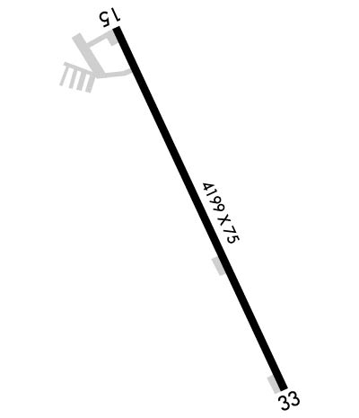
  • Runway Identifications
    Runway Identification: 15/33
    Length: 4199 ft
    Width: 75 ft
    Surface: CONCRETE-FAIR CONDITION
    Edge lights: Medium Intensity

    Treatment: NONE
    Weight: PCN 7 /R/C/W/U

     Runway: 15   Runway: 33
    Mag heading: 150°Mag heading: 330°
    Rwy Slope: -.16% DownRwy Slope: .16% Up
    Approach: Approach:
    Pattern: Left TrafficPattern: Left Traffic
    Markings: NONPRECISION INSTRUMENTMarkings: NONPRECISION INSTRUMENT
    Marking Condition: FAIRMarking Condition: FAIR
    Arresting Dev: Arresting Dev:
    Lat & Long: N4312.8  W09550.2Lat. & Long.: N4312.2  W09549.8
    Elev: 1419.2 ft. MSLElev: 1412.6 ft. MSL
    TCH: 40 ft. AGLTCH: 40 ft. AGL
    Visual Glide Path: 3.00 degreesVisual Glide Path: 3.00 degrees
    Displaced Threshold: NoDisplaced Threshold: No
    Touchdown Zone: YESTouchdown Zone: YES
    Touchdown Elev.: 1419.2 feetTouchdown Elev.: 1419.0 feet
    Visual Glide Slope: 2-Light PAPI on LEFT side of RunwayVisual Glide Slope: 2-Light PAPI on LEFT side of Runway
    RVR Equipment: RVR Equipment:
    RVV Equipment: NORVV Equipment: NO
    Approach Lights: Approach Lights:
    REIL: YESREIL: YES
    Centerline Lights: NOCenterline Lights: NO
    Touchdown lights: NOTouchdown lights: NO
    Runway Category: Runway with a Non-precision Approach having visibility minimums greater than 3/4 mileRunway Category: Runway with a Non-precision Approach having visibility minimums greater than 3/4 mile
    Declared Distances: Declared Distances:
    Obstructions: ROADObstructions: TREES
    Marked: NOT Marked/LightedMarked: NOT Marked/Lighted
    Clearance slope: 20:1Clearance slope: 33:1
    Obstruction height: 15 feet AGLObstruction height: 38 feet AGL
    Dist. from runway: 500 feetDist. from runway: 1490 feet
    Centerline offset: 165 left of centerlineCenterline offset: 400 feet right of centerline
    Comments: Comments:
    C:9/P: