GLOBAL SELECT AT SUGAR LAND REGIONAL AIRPORT

KSGR

SUGAR LAND RGNL
HOUSTON
TX
Time Zone: Central
Lat: N 2937.3
Long: W 09539.4
Elev: 81
Var: -05
Longest Runway: 8000
Clr Del: 119.25 TW CLD
Dept. ATIS: 118.12
Arr. ATIS: 118.12
AWOS: 118.12
Ground: 121.4
Tower: 118.65

FBO & Flight Services info for KSGR

FBOs: Update your Fuel Prices

  click here  
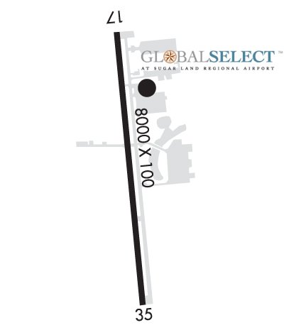
The destination of choice for the business traveler in the Houston area!
Amenities: New 20K sq. ft corporate aviation terminal, a state-of-the-art air traffic control tower & radar system; a reinforced, concrete runway measuring 100ft wide x 8,000ft in length, accommodating the largest of the corporate-type business jets; & an instrument landing system w/high-intensity lighting.
Ph: 866-435-9747 Fax: 281-494-4179 Freq: 122.95WebsiteE-Mail
                     
Service
Jet
100LL
SAF
MoGas
Fuel Avail: 0500 to 2300
Full5.466.45    Last Update: 04/16/2024 08:17
PRICES GUARANTEED by FBO.
Self  5.45    
Misc. Info: Annual Jet Fuel Volume Discounts AvailableAddress: 12888 HIGHWAY 6, SOUTH,   SUGAR LAND, TX 77498
MAINTENANCE & AVIONICS SERVICE TRUSTED BY PRIVATE OWNERS & CHARTER OPERATORS! Western Airways is an FAA-Certified Part 145 Repair Station servicing most Part 25 jets & Part 23 turboprop models. We're here for maintenance, repairs, major & minor inspections and avionics service & installations. We're an authorized dealer & service center for Garmin, Gogo, AirText & more. AOG mobile service avail!
Ph: 800-373-0896
-
-
WebsiteE-Mail
Service
Jet
100LL
SAF
MoGas
Fuel Avail: NO FUEL AVAILABLE
Full        Last Update: 04/19/2024 00:01:45

Self        
Misc. Info: Part 145 Repair StationAddress: 100 JIM DAVIDSON DR.,   SUGAR LAND, TX 77498

AWOSPh: 281-242-7605
-
Freq: 118.12  
If you are an FBO, call 1-203-262-1700 to update your info or email: FltPlan.Advertising@garmin.com
Advertise your FBO on FltPlan.com
FBOs at nearby airports who want your business:
KTME


  click here  
ONE OF THE FINEST BUSINESS AVIATION AIRPORTS IN THE US! EASY ACCESS to the west Houston energy corridor and the Greater Houston Metro Area. 24/7 First Class FBO Services! Amenities Include: Quick Turns, WSI Weather Service, Volume Fuel Discounts, Plush Crew Lounge, Complimentary Coffee, GPU & Lav Service, Catering and Complimentary Crew cars.
Ph: 281-945-5000 WebsiteE-MailFax: 281-945-4350 Freq: 122.97
KCXO


  click here  
At Galaxy FBO, we strive to meet & exceed expectations, continuously working to improve your experience. Our new facility at the Conroe North Houston Regional Airport features world-class amenities including an arrival/departure canopy large enough to accommodate even the largest corporate jet. Customs & Border Patrol Federal Inspection Station is now in operation, accepting international flights.
Ph: 1-936-494-4252WebsiteE-MailFax: 1-936-494-0176Freq: 130.52
KDWH


  click here  
OPEN 24 HOURS. Offering Quick Turns, Pilots Lounge, AC Maintenance, PAX Terminal, Hangar Space, Rental Cars, Ramp & Tie-Down Parking, Crew Cars, Courtesy Transportation, Lav Service, Catering, Wifi/Internet Access, Conference Room, Hotel Reservations, Avionics Sales, Restaurant, Volume Fuel.
Ph: 1-281-376-5436WebsiteE-MailFax: 1-281-251-0030Freq: 122.95

Runway & Approach Info for KSGR
Rwy
Length
Land Dist**
Approach*
  Rwy
Length
Land Dist**
Approach*
17
8000x100  7620'          
 
  
35
  8000x100  6016'          
ILS/DME
 110.70 - 350°  
 * only ILS, LOC, LDA, and SDF approaches to a specific runway are shown
** For any Declared Landing Distance Available, please see A/FD or Approach plates
Runway Weight Capability (lbs.) Help
Runway IDSingle WheelDouble WheelDouble Tandem WheelDual Double Wheel
17/3580,000120,000200,000600,000
These numbers are Advisory and are not limits.   The Airport Manager should have more accurate Weight Limits
Approach Charts
Sugar Land Regional AirportApproaches    
Current Weather/Notams
Customs Information Send updates to Support@FltPlan.com
Phone 281-277-1453
Fax N/A

Comments Customs User Fee * Hours: Mon-Fri 0830-1700 * after hours/weekends available with advanced notice * Call FBO 1-866-435-9747 for fee schedule.
Database effective 04/18/2024
Airport Diagram of KSGR
Airport Diagram might not be current.

Facility Name: SUGAR LAND RGNL
City Name: HOUSTON
County: FORT BEND
State abbrev: TX
State Name: TEXAS
   
Ownership: PUBLICLY OWNED
Use: OPEN TO THE PUBLIC
Owner's Name: CITY OF SUGAR LAND
Address: PO BOX 110
 SUGAR LAND, TX 77487-0110
Owner's Phone: 281-275-2100
  
Manager's Name: ELIZABETH V. ROSENBAUM
Address: 12888 B HWY 6 SOUTH
 SUGAR LAND, TX 77498
Phone: 281-275-2100
   
FAA Region: SOUTHWEST
FAA Field Office: TEX


Sunrise / Sunset times for SUGAR LAND RGNL

DateSunriseSunset
04/18/24 Thursday6:5219:52
04/19/24 Friday6:5119:52
04/20/24 Saturday6:5019:53
04/21/24 Sunday6:4919:54
04/22/24 Monday6:4819:54
04/23/24 Tuesday6:4719:55
04/24/24 Wednesday6:4619:56
04/25/24 Thursday6:4519:56
04/26/24 Friday6:4419:57
04/27/24 Saturday6:4319:57
04/28/24 Sunday6:4219:58
04/29/24 Monday6:4119:59
04/30/24 Tuesday6:4119:59
05/01/24 Wednesday6:4020:00

Airport Facilities

Airport Attendance Schedule7 Days A Week 0500-2300
Airport Status OPERATIONAL (This Status can change at any time - please check NOTAMS)
Airport Lighting ScheduleWHEN ATCT CLSD ACTVT REIL RWY 17 & 35; HIRL RWY 17/35 - CTAF.
Airport Storage AvailableTie Downs, Hanger
Extra Services AvailableAir Ambulance, Charter, Flight Instruction, Aircraft Rental
Wind IndicatorYES - (lighted)
Control TowerYES
CTAF Frequency118.650
Unicom Frequency122.950
Rotating Beacon ColorWG
Segmented CircleYES
Landing FeeYES; RAMP FEE FOR CIVIL ACFT; WAIVED WITH FUEL PURCHASE.

Airport Inspection Data

Airport InspectedSTATE - performed by PRIVATE CONTRACT PERSONNEL
Inspection Date04/14/2023

Airport Services

Type of Fuel AvailableGrade 100LL, JET A; -10100LL AVBL 24 HRS SELF SERVE. FOR JET A+ AFT HRS CALL 281-275-2400 DURG ATNDD HRS.
Airframe Repair ServiceMAJOR
Power Plant Repair ServiceMAJOR

Geographic Data

LatitudeN2937.3
LongitudeW09539.4 (ESTIMATED)
Arpt Elevation81ft (SURVEYED)
Magnetic Variation05E
17 miles SWof HOUSTON
Traffic Pattern Altitude
Sectional ChartHOUSTON

Aircraft Data

Operations (Reported)YearlyAvg. Daily
General Aviation Transient 413911
General Aviation Local 3091885
Air Taxi 868524
Commerical 00
Commuter 00
Military 2311
Aircraft based on Field
General Aviation Singles 98
General Aviation Multi 18
Jet Aircraft 37
General Aviation Helicopters 4
Military Aircraft 0
Gliders 0
Ultralights 0

FAA Services

FSS on field NO
FSS tie-in MONTGOMERY COUNTY
FSS Phone 1-800-WX-BRIEF
Who issues Notams SGR
Notam D service at airport YES
ARTCC Name HOUSTON

Federal Status

Airport Certification
Aircraft Rescue & Firefighting IndexNone
Airport of EntryNo
Custom Landing RightsNo; US CUSTOMS USER FEE ARPT.
Joint Civil/MilitaryNo
Military Landing rightsNo

Federal Agreements

NATIONAL PLAN OF INTEGRATED AIRPORT SYSTEMS (NPIAS)

Remarks

NO TGLS AFT TWR CLOSES.
LRA M-F 0800-12-- & 1300-1700. OTR TIMES BY APPT.
MIL AND CORPORATE GND TRANSPORTATION PRVDD.
BIRDS ON & INVOF ARPT.
NOISE ABATEMENT PROC: NOISE SENSITIVE AREAS - INFO AVBL AT TRML.
NO INT DEPS FOR MULTI-ENGINE ACFT.
FOR CD WHEN ATCT IS CLSD CTC HOUSTON APCH AT 281-443-5844 TO CNL IFR AT 281-443-5888.
SFC CONDS NOT RPRTD FRI 10:00 PM - SUN 10:00 PM.
RWY 17/3 5 RWY NOT GRVD.
Airport Communications & Frequencies:
ATIS Frequencies:   Hours(local) of Operation: 0600-2200
118.125
SUGAR LAND Tower Frequencies:   Hours(local) of operation: 0600-2200   
118.65
SUGAR LAND Ground Frequencies:
121.4
Clearance Delivery Frequencies:
119.25 WHEN TWR CLSD
121.4
CTAF Frequency:
118.650
Unicom Frequency:
122.950
HOUSTON Primary Approach Frequencies:  
123.8
257.7
Part-time Approach Frequencies:  
123.8
HOUSTON Primary Departure Frequencies:  
123.8
257.7
Part-time Departure Frequencies:  
123.8
Runway Identifications
Runway Identification: 17/35
Length: 8000 ft
Width: 100 ft
Surface: CONCRETE
Edge lights: High Intensity

Treatment: NONE

 Runway: 17   Runway: 35
Mag heading: 170°Mag heading: 350°
Rwy Slope: -.09% DownRwy Slope: .09% Up
Approach: Approach: ILS/DME
Pattern: Left TrafficPattern: Left Traffic
Markings: PRECISION INSTRUMENTMarkings: PRECISION INSTRUMENT
Marking Condition: GOODMarking Condition: GOOD
Arresting Dev: Arresting Dev:
Lat & Long: N2938.0  W09539.5Lat. & Long.: N2936.7  W09539.3
Elev: 81.1 ft. MSLElev: 73.6 ft. MSL
TCH: 52 ft. AGLTCH: 56 ft. AGL
Visual Glide Path: 3.50 degreesVisual Glide Path: 3.00 degrees
Displaced Threshold: 380 feetDisplaced Threshold: 1984 feet
Touchdown Zone: YESTouchdown Zone: YES
Touchdown Elev.: 81.1 feetTouchdown Elev.: 78.0 feet
Visual Glide Slope: 2-Light PAPI on RIGHT side of RunwayVisual Glide Slope: 4-Light PAPI on LEFT side of Runway
RVR Equipment: RVR Equipment:
RVV Equipment: NORVV Equipment: NO
Approach Lights: Approach Lights:
REIL: YESREIL: YES
Centerline Lights: NOCenterline Lights: NO
Touchdown lights: NOTouchdown lights: NO
Runway Category: Runway with a Non-precision Approach having visibility minimums greater than 3/4 mileRunway Category: Precision Instrument Runway
Declared Distances: Declared Distances:
Obstructions: TREESObstructions: PLINE
Marked: NOT Marked/LightedMarked: NOT Marked/Lighted
Clearance slope: 1:1; APCH SLOPE 9:1 AT DSPLCD THR.Clearance slope: APCH SLOPE 50:1 TO DSPLCD THR TO +27 FT RR TRACKS, 2074 FT FM THR, 0:1 TO 29 FT TREES AT 486 FT LEFT.
Obstruction height: 55 feet AGLObstruction height: 30 feet AGL
Dist. from runway: 280 feetDist. from runway: 201 feet
Centerline offset: 520 right of centerlineCenterline offset: 200 feet left of centerline
Comments: 10 FT RD 0-57 FT FM THR, 50 FT TREES, 0-100 FT DSTC, 488 FT L.Comments: +27 FT RR 90 FT FM THR ON CNTRLN; +17 FT RD, +30 FT PWRLINE.
C:205/P: