KSGJ

NORTHEAST FLORIDA RGNL
ST AUGUSTINE
FL
Time Zone: Eastern
Lat: N 2957.6
Long: W 08120.4
Elev: 10
Var: +04
Longest Runway: 8001
Dept. ATIS: 119.62
Arr. ATIS: 119.62
AWOS: 119.62
Ground: 121.17
Tower: 127.62

FBO & Flight Services info for KSGJ

FBOs: Update your Fuel Prices
Atlantic Aviation is your premier aviation service provider with more than 100 locations in North America, including Hawaii and the Caribbean. We provide standard ground services you'd expect, with a detailed focus on ensuring an unforgettable customer experience.
Ph: 904-824-1995 Fax: 904-824-4509 Freq: 130.05WebsiteE-Mail
                   
Service
Jet
100LL
SAF
MoGas
Fuel Avail: 0600-2359 After hours upon request
Full7.768.30    Last Update: 04/22/2024 13:29:01
PRICES GUARANTEED by FBO. *
*Please request Fltplan.com discount at front counter
Self        
Misc. Info: Please request Fltplan.com discount at front counterAddress: 4900 US 1 NORTH   ST AUGUSTINE, FL 32095

ST AUGUSTINE ARPTPh: 904-209-0090 Fax: 904-209-0528
-
Service
Jet
100LL
SAF
MoGas
Fuel Avail: Carries only 100LL Self Service, 24/7 with credit card
Full        Last Update: 04/05/2024 11:23  
Self  4.75    
 Address: 4796 US HIGHWAY 1 NORTH   ST. AUGUSTINE, FL 32095
CUSTOMSPh: 904-209-0099
-
-
 
AWOSPh: 904-824-7084
-
Freq: 119.62  
If you are an FBO, call 1-203-262-1700 to update your info or email: FltPlan.Advertising@garmin.com
Advertise your FBO on FltPlan.com

Runway & Approach Info for KSGJ
Rwy
Length
Land Dist**
Approach*
  Rwy
Length
Land Dist**
Approach*
02
2609x75  2609'          
 
  
20
  2609x75  2609'          
 
06
2701x60  2701'          
 
  
24
  2701x60  2701'          
 
12W
5000x1000  5000'          
 
  
30W
  5000x1000  5000'          
 
13
8001x150  6945'          
 
  
31
  8001x150  7195'          
ILS/DME
 111.10 - 311°  
17W
12000x1000  12000'          
 
  
35W
  12000x1000  12000'          
 
18W
12000x500  12000'          
 
  
36W
  12000x500  12000'          
 
 * only ILS, LOC, LDA, and SDF approaches to a specific runway are shown
** For any Declared Landing Distance Available, please see A/FD or Approach plates
Runway Weight Capability (lbs.) Help
Runway IDSingle WheelDouble WheelDouble Tandem WheelDual Double Wheel
02/20100,000203,500N/AN/A
06/2446,50085,000N/AN/A
12W/30WN/AN/AN/AN/A
13/31100,000280,000560,0001,120,000
17W/35WN/AN/AN/AN/A
18W/36WN/AN/AN/AN/A
These numbers are Advisory and are not limits.   The Airport Manager should have more accurate Weight Limits
Approach Charts
Approaches    
Current Weather/Notams
Customs Information Send updates to Support@FltPlan.com
Phone 904-209-0099
Fax 904-209-0098

Comments Operational Hours: 11:30 AM-8:00PM(Eastern) Mon. Th. Fr. Sat. Sun.
Database effective 05/16/2024
Airport Diagram of KSGJ
Airport Diagram might not be current.

Facility Name: NORTHEAST FLORIDA RGNL
City Name: ST AUGUSTINE
County: ST JOHNS
State abbrev: FL
State Name: FLORIDA
   
Ownership: PUBLICLY OWNED
Use: OPEN TO THE PUBLIC
Owner's Name: ST AUGUSTINE ARPT AUTH
Address: 4796 US 1 NORTH
 ST AUGUSTINE, FL 32095
Owner's Phone: 904-209-0090
  
Manager's Name: JAMIE TOPP
Address: 4796 US 1 NORTH
 ST AUGUSTINE, FL 32095
Phone: 904-209-0090
   
FAA Region: SOUTHERN
FAA Field Office: ORL


Sunrise / Sunset times for NORTHEAST FLORIDA RGNL

DateSunriseSunset
04/22/24 Monday6:5019:57
04/23/24 Tuesday6:4919:58
04/24/24 Wednesday6:4819:59
04/25/24 Thursday6:4719:59
04/26/24 Friday6:4620:00
04/27/24 Saturday6:4620:01
04/28/24 Sunday6:4520:01
04/29/24 Monday6:4420:02
04/30/24 Tuesday6:4320:03
05/01/24 Wednesday6:4220:03
05/02/24 Thursday6:4120:04
05/03/24 Friday6:4020:05
05/04/24 Saturday6:3920:05
05/05/24 Sunday6:3920:06

Airport Facilities

Airport Attendance Schedule7 Days A Week 0600-2200
Airport Status OPERATIONAL (This Status can change at any time - please check NOTAMS)
Airport Lighting ScheduleACTVT MALSR RWY 31; HIRL RWY 13/31; MIRL RWY 06/24 & 2/20 - CTAF. PAPI RWY 06 & 31 AND VASI RWY 13 OPR CONSLY.
Airport Storage AvailableTie Downs, Hanger
Extra Services AvailableAir Ambulance, Avionics, Charter, Flight Instruction, Aircraft Rental, Aircraft Sales
Wind IndicatorYES - (lighted)
Control TowerYES
CTAF Frequency127.625
Unicom Frequency122.950
Rotating Beacon ColorWG
Segmented CircleYES
Landing FeeNO

Airport Inspection Data

Airport InspectedFEDERAL - performed by FAA AIRPORTS FIELD PERSONNEL
Inspection Date10/07/2021

Airport Services

Type of Fuel AvailableGrade 100LL, JET A (freeze point -40C); -A SELF SVC FUEL AVBL 24 HRS WITH CREDIT CARD.; -10JET SINGLE POINT REFUELING AVBL.
Airframe Repair ServiceMAJOR
Power Plant Repair ServiceMAJOR

Geographic Data

LatitudeN2957.6
LongitudeW08120.4 (ESTIMATED)
Arpt Elevation9ft (SURVEYED)
Magnetic Variation04W
4 miles Nof ST AUGUSTINE
Traffic Pattern Altitude
Sectional ChartJACKSONVILLE

Aircraft Data

Operations (Reported)YearlyAvg. Daily
General Aviation Transient 49329135
General Aviation Local 58160159
Air Taxi 629017
Commerical 20
Commuter 00
Military 22646
Aircraft based on Field
General Aviation Singles 162
General Aviation Multi 31
Jet Aircraft 18
General Aviation Helicopters 5
Military Aircraft 22
Gliders 0
Ultralights 0

FAA Services

FSS on field NO
FSS tie-in GAINESVILLE
FSS Phone 1-800-WX-BRIEF
Who issues Notams SGJ
Notam D service at airport YES
ARTCC Name JACKSONVILLE

Federal Status

Airport CertificationAIRPORT RECEIVING SCHEDULED AIR CARRIER SERVICE FROM CARRIERS CERTIFICATED BY THE CIVIL AERONAUTICS BOARD; PPR 24 HRS FOR UNSKED ACR OPS WITH MORE THAN 30 PAX SEATS CALL AMGR 904-209-0090.
Aircraft Rescue & Firefighting IndexAIRPORT HAS A CERTIFICATE UNDER CFR PART 139
Airport of EntryNo
Custom Landing RightsNo; US CUSTOMS USER FEE ARPT.
Joint Civil/MilitaryNo
Military Landing rightsYES

Federal Agreements

NATIONAL PLAN OF INTEGRATED AIRPORT SYSTEMS (NPIAS)
GRANT AGREEMENTS UNDER FAAP/ADAP/AIP
SURPLUS PROPERTY AGREEMENT UNDER REGULATION 16-WAA
ASSURANCES PURSUANT TO TITLE VI, CIVIL RIGHTS ACT OF 1964
AGREEMENT UNDER DLAND OR DCLA HAS EXPIRED.

Remarks

AEROBATIC ACT E SIDE OF RWY 13/31 CTC TWR FOR TFC & GNV RADIO FOR TIMES.
FICON NOT MNTD 2100 - 0700 LCL.
FOR CD IF UNA TO CTC ON FSS FREQ, CTC JACKSONVILLE APCH AT 904-741-0284.
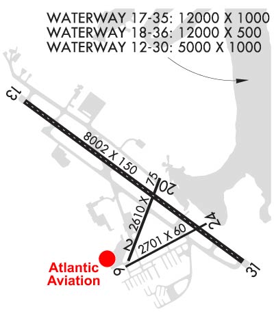
RWYS 06/24, 02/20, 12W/30W, 17W/35W & 18W/36W NOT AVBL FOR SKED ACR OPNS WITH MORE THAN 9 PAX SEATS OR UNSKED ACR AT LEAST 31 PAX SEATS
Airport Communications & Frequencies:
ATIS Frequencies:   Hours(local) of Operation: CONTINUOUS
119.625
ST AUGUSTINE Tower Frequencies:   Hours(local) of operation: 0700-2100   
127.625
269.475
ST AUGUSTINE Ground Frequencies:
121.175
251.125
CTAF Frequency:
127.625
Unicom Frequency:
122.950
JACKSONVILLE Primary Approach Frequencies:  
120.75
JACKSONVILLE Primary Departure Frequencies:  
120.75
Runway Identifications
Runway Identification: 02/20
Length: 2609 ft
Width: 75 ft
Surface: ASPHALT-GOOD CONDITION
Edge lights: Medium Intensity

Treatment: NONE
Weight: PCN 53 /F/A/X/T

 Runway: 02   Runway: 20
Mag heading: 25°Mag heading: 205°
Rwy Slope: -.14% DownRwy Slope: .14% Up
Approach: Approach:
Pattern: Left TrafficPattern: Left Traffic
Markings: BASICMarkings: BASIC
Marking Condition: GOODMarking Condition: GOOD
Arresting Dev: Arresting Dev:
Lat & Long: N2957.3  W08120.5Lat. & Long.: N2957.7  W08120.3
Elev: 9.1 ft. MSLElev: 5.5 ft. MSL
TCH: TCH:
Visual Glide Path: Visual Glide Path:
Displaced Threshold: NoDisplaced Threshold: No
Touchdown Zone: YESTouchdown Zone: YES
Touchdown Elev.: 9.3 feetTouchdown Elev.: 9.3 feet
Visual Glide Slope: Visual Glide Slope:
RVR Equipment: RVR Equipment:
RVV Equipment: NORVV Equipment: NO
Approach Lights: Approach Lights:
REIL: NOREIL: NO
Centerline Lights: NOCenterline Lights: NO
Touchdown lights: NOTouchdown lights: NO
Runway Category: Runway with a Visual ApproachRunway Category: Runway with a Visual Approach
Declared Distances: TORA:2610' TODA:2610' ASDA:2610' LDA:2610'Declared Distances: TORA:2610' TODA:2610' ASDA:2610' LDA:2610'
Obstructions: TREESObstructions:
Marked: NOT Marked/LightedMarked:
Clearance slope: 15:1Clearance slope: 50:1
Obstruction height: 76 feet AGLObstruction height:
Dist. from runway: 1345 feetDist. from runway:
Centerline offset: 75 left of centerlineCenterline offset:
Comments: Comments:
Runway Identification: 06/24
Length: 2701 ft
Width: 60 ft
Surface: ASPHALT-FAIR CONDITION
Edge lights: Medium Intensity

Treatment: NONE
Weight: PCN 19 /F/A/X/T

 Runway: 06   Runway: 24
Mag heading: 66°Mag heading: 246°
Rwy Slope: -.14% DownRwy Slope: .14% Up
Approach: Approach:
Pattern: Left TrafficPattern: Left Traffic
Markings: BASICMarkings: BASIC
Marking Condition: GOODMarking Condition: GOOD
Arresting Dev: Arresting Dev:
Lat & Long: N2957.2  W08120.5Lat. & Long.: N2957.4  W08120.0
Elev: 9.6 ft. MSLElev: 5.9 ft. MSL
TCH: 47 ft. AGLTCH:
Visual Glide Path: 3.25 degreesVisual Glide Path:
Displaced Threshold: NoDisplaced Threshold: No
Touchdown Zone: YESTouchdown Zone: YES
Touchdown Elev.: 9.7 feetTouchdown Elev.: 9.7 feet
Visual Glide Slope: 2-Light PAPI on LEFT side of RunwayVisual Glide Slope:
RVR Equipment: RVR Equipment:
RVV Equipment: NORVV Equipment: NO
Approach Lights: Approach Lights:
REIL: NOREIL: NO
Centerline Lights: NOCenterline Lights: NO
Touchdown lights: NOTouchdown lights: NO
Runway Category: Runway with a Visual ApproachRunway Category: Runway with a Visual Approach
Declared Distances: TORA:2701' TODA:2701' ASDA:2701' LDA:2701'Declared Distances: TORA:2701' TODA:2701' ASDA:2701' LDA:2701'
Obstructions: TREESObstructions:
Marked: NOT Marked/LightedMarked:
Clearance slope: 16:1Clearance slope: 50:1
Obstruction height: 53 feet AGLObstruction height:
Dist. from runway: 1055 feetDist. from runway:
Centerline offset: 145 right of centerlineCenterline offset:
Comments: Comments:
Runway Identification: 12W/30W
Length: 5000 ft
Width: 1000 ft
Surface: WATER
Edge lights:

Treatment: NONE

 Runway: 12W   Runway: 30W
Mag heading: N/AMag heading: N/A
Approach: Approach:
Pattern: Left TrafficPattern: Left Traffic
Markings: Markings:
Marking Condition: Marking Condition:
Arresting Dev: Arresting Dev:
Lat & Long:   Lat. & Long.:   
Elev: N/AElev: N/A
TCH: TCH:
Visual Glide Path: Visual Glide Path:
Displaced Threshold: NoDisplaced Threshold: No
Touchdown Zone: NOTouchdown Zone: NO
Touchdown Elev.: Touchdown Elev.:
Visual Glide Slope: Visual Glide Slope:
RVR Equipment: RVR Equipment:
RVV Equipment: NORVV Equipment: NO
Approach Lights: Approach Lights:
REIL: NOREIL: NO
Centerline Lights: NOCenterline Lights: NO
Touchdown lights: NOTouchdown lights: NO
Runway Category: Runway with a Visual ApproachRunway Category: Runway with a Visual Approach
Declared Distances: Declared Distances:
Runway Identification: 13/31
Length: 8001 ft
Width: 150 ft
Surface: ASPHALT-GOOD CONDITION
Edge lights: High Intensity

Treatment: GROOVED
Weight: PCN 126/F/A/W/T

 Runway: 13   Runway: 31
Mag heading: 130°Mag heading: 310°
Rwy Slope: -.05% DownRwy Slope: .05% Up
Approach: Approach: ILS/DME
Pattern: Left TrafficPattern: Left Traffic
Markings: PRECISION INSTRUMENTMarkings: PRECISION INSTRUMENT
Marking Condition: GOODMarking Condition: GOOD
Arresting Dev: Arresting Dev:
Lat & Long: N2958.0  W08121.0Lat. & Long.: N2957.3  W08119.8
Elev: 9.5 ft. MSLElev: 5.7 ft. MSL
TCH: 44 ft. AGLTCH: 54 ft. AGL
Visual Glide Path: 3.00 degreesVisual Glide Path: 3.00 degrees
Displaced Threshold: 1056 feetDisplaced Threshold: 806 feet
Touchdown Zone: YESTouchdown Zone: YES
Touchdown Elev.: 9.8 feetTouchdown Elev.: 7.5 feet
Visual Glide Slope: 4-BOX VASI ON LEFT SIDE OF RUNWAYVisual Glide Slope: 4-Light PAPI on LEFT side of Runway
RVR Equipment: RVR Equipment:
RVV Equipment: NORVV Equipment: NO
Approach Lights: Approach Lights: MALSR - 1,400 foot medium intensity approach lighting system with runway alignment indicator lights
REIL: NOREIL: NO
Centerline Lights: YESCenterline Lights: YES
Touchdown lights: NOTouchdown lights: NO
Runway Category: Runway with a Non-precision Approach having visibility minimums greater than 3/4 mileRunway Category: Precision Instrument Runway
Declared Distances: TORA:8001' TODA:8001' ASDA:7202' LDA:6144'Declared Distances: TORA:8001' TODA:8001' ASDA:6730' LDA:5925'
Obstructions: ROADObstructions:
Marked: NOT Marked/LightedMarked:
Clearance slope: RWY 13 APCH SLP 34:1 TO MKD DSPCD THR.Clearance slope: 50:1
Obstruction height: 15 feet AGLObstruction height:
Dist. from runway: 200 feetDist. from runway:
Centerline offset: 150 right of centerlineCenterline offset:
Comments: ROAD 15 FT TALL 200 FT BFR AER OF RWY 13 150 RIGHT OF CNTRLN.Comments:
Runway Identification: 17W/35W
Length: 12000 ft
Width: 1000 ft
Surface: WATER
Edge lights:

Treatment: NONE

 Runway: 17W   Runway: 35W
Mag heading: N/AMag heading: N/A
Approach: Approach:
Pattern: Left TrafficPattern: Left Traffic
Markings: Markings:
Marking Condition: Marking Condition:
Arresting Dev: Arresting Dev:
Lat & Long:   Lat. & Long.:   
Elev: N/AElev: N/A
TCH: TCH:
Visual Glide Path: Visual Glide Path:
Displaced Threshold: NoDisplaced Threshold: No
Touchdown Zone: NOTouchdown Zone: NO
Touchdown Elev.: Touchdown Elev.:
Visual Glide Slope: Visual Glide Slope:
RVR Equipment: RVR Equipment:
RVV Equipment: NORVV Equipment: NO
Approach Lights: Approach Lights:
REIL: NOREIL: NO
Centerline Lights: NOCenterline Lights: NO
Touchdown lights: NOTouchdown lights: NO
Runway Category: Runway with a Visual ApproachRunway Category: Runway with a Visual Approach
Declared Distances: Declared Distances:
Runway Identification: 18W/36W
Length: 12000 ft
Width: 500 ft
Surface: WATER
Edge lights:

Treatment: NONE

 Runway: 18W   Runway: 36W
Mag heading: N/AMag heading: N/A
Approach: Approach:
Pattern: Left TrafficPattern: Left Traffic
Markings: Markings:
Marking Condition: Marking Condition:
Arresting Dev: Arresting Dev:
Lat & Long:   Lat. & Long.:   
Elev: N/AElev: N/A
TCH: TCH:
Visual Glide Path: Visual Glide Path:
Displaced Threshold: NoDisplaced Threshold: No
Touchdown Zone: NOTouchdown Zone: NO
Touchdown Elev.: Touchdown Elev.:
Visual Glide Slope: Visual Glide Slope:
RVR Equipment: RVR Equipment:
RVV Equipment: NORVV Equipment: NO
Approach Lights: Approach Lights:
REIL: NOREIL: NO
Centerline Lights: NOCenterline Lights: NO
Touchdown lights: NOTouchdown lights: NO
Runway Category: Runway with a Visual ApproachRunway Category: Runway with a Visual Approach
Declared Distances: Declared Distances:
C:106/P: