Click here for more info on on SMS!

KSGF

SPRINGFIELD-BRANSON NATIONAL
SPRINGFIELD
MO
Time Zone: Central
Lat: N 3714.7
Long: W 09323.3
Elev: 1268
Var: -03
Longest Runway: 8000
Clr Del: 123.67
Dept. ATIS: 135.12
Arr. ATIS: 135.12
Ground: 121.9
Tower: 119.9

FBO & Flight Services info for KSGF

FBOs: Update your Fuel Prices
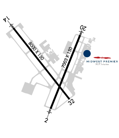
Springfield-Branson Airport/Midwest Premier SGF Aviation

The sky is the limit when it comes to your satisfaction!
High quality, prompt, courteous & responsive ground service! From competitively priced fuel with attractive discounts to arranging transportation, we will make your experience exceptional. Services include catering, aircraft tie down, conference room, & pilots lounge.
Ph: 417-868-0590 Fax: 417-868-0591 Freq: 122.95WebsiteE-Mail
                   
Service
Jet
100LL
SAF
MoGas
Fuel Avail: 24/7
Full6.276.44    Last Update: 03/27/2024 16:25

Self        
Misc. Info: volume discount 250 gallons or moreAddress: 2801 N. GENERAL AVIATION AVENUE, SPRINGFIELD, MO 65803

ASOSPh: 417-863-6158
-
-
 
If you are an FBO, call 1-203-262-1700 to update your info or email: FltPlan.Advertising@garmin.com
Advertise your FBO on FltPlan.com

Runway & Approach Info for KSGF
Rwy
Length
Land Dist**
Approach*
  Rwy
Length
Land Dist**
Approach*
02
7003x150  7003'          
ILS/DME
 109.90 - 018°  
  
20
  7003x150  7003'          
 
14
8000x150  8000'          
ILS/DME
 109.70 - 138°  
  
32
  8000x150  8000'          
 
 * only ILS, LOC, LDA, and SDF approaches to a specific runway are shown
** For any Declared Landing Distance Available, please see A/FD or Approach plates
Runway Weight Capability (lbs.) Help
Runway IDSingle WheelDouble WheelDouble Tandem WheelDual Double Wheel
02/20135,000170,000300,000N/A
14/32135,000170,000300,000N/A
These numbers are Advisory and are not limits.   The Airport Manager should have more accurate Weight Limits
Approach Charts
Approaches    
Current Weather/Notams
Customs Information Send updates to Support@FltPlan.com
Phone 417-868-0545
Fax 417-868-0546

Comments 2 hrs advance notice required. Business hrs 0830-1630 Monday-Friday. *Maximum passengers per flight: 20 *Call prior to 1700 on preceding weekday.
Database effective 05/16/2024
Airport Diagram of KSGF
Airport Diagram might not be current.

Facility Name: SPRINGFIELD-BRANSON NTL
City Name: SPRINGFIELD
County: GREENE
State abbrev: MO
State Name: MISSOURI
   
Ownership: PUBLICLY OWNED
Use: OPEN TO THE PUBLIC
Owner's Name: CITY OF SPRINGFIELD
Address: 2300 N AIRPORT BLVD, SUITE 100
 SPRINGFIELD, MO 65802
Owner's Phone: 417-868-0500
  
Manager's Name: MR. BRIAN C WEILER, A.A.E.; DIRECTOR OF AVIATION.
Address: 2300 N AIRPORT BLVD, SUITE 100
 SPRINGFIELD, MO 65802
Phone: 417-868-0500
   
FAA Region: CENTRAL
FAA Field Office: NONE


Sunrise / Sunset times for SPRINGFIELD-BRANSON NTL

DateSunriseSunset
04/22/24 Monday6:2919:56
04/23/24 Tuesday6:2719:57
04/24/24 Wednesday6:2619:57
04/25/24 Thursday6:2519:58
04/26/24 Friday6:2419:59
04/27/24 Saturday6:2320:00
04/28/24 Sunday6:2120:01
04/29/24 Monday6:2020:02
04/30/24 Tuesday6:1920:03
05/01/24 Wednesday6:1820:04
05/02/24 Thursday6:1720:05
05/03/24 Friday6:1620:06
05/04/24 Saturday6:1520:06
05/05/24 Sunday6:1420:07

Airport Facilities

Airport Attendance ScheduleCONTINUOUS
Airport Status OPERATIONAL (This Status can change at any time - please check NOTAMS)
Airport Lighting ScheduleSS-SR
Airport Storage AvailableTie Downs, Hanger
Extra Services AvailableAir Freight, Air Ambulance, Avionics, Charter, Flight Instruction, Aircraft Rental, Aircraft Sales
Wind IndicatorYES - (lighted)
Control TowerYES
CTAF Frequency
Unicom Frequency122.950
Rotating Beacon ColorWG
Segmented CircleNO
Landing FeeNO

Airport Inspection Data

Airport InspectedFEDERAL - performed by FAA AIRPORTS FIELD PERSONNEL
Inspection Date01/24/2024

Airport Services

Type of Fuel AvailableGrade 100LL, JET A (freeze point -40C)
Airframe Repair ServiceMAJOR
Power Plant Repair ServiceMAJOR

Geographic Data

LatitudeN3714.7
LongitudeW09323.3 (ESTIMATED)
Arpt Elevation1268ft (SURVEYED)
Magnetic Variation03E
5 miles NWof SPRINGFIELD
Traffic Pattern Altitude1000
Sectional ChartKANSAS CITY

Aircraft Data

Operations (Reported)YearlyAvg. Daily
General Aviation Transient 1190133
General Aviation Local 1029828
Air Taxi 988627
Commerical 1458440
Commuter 00
Military 381510
Aircraft based on Field
General Aviation Singles 73
General Aviation Multi 6
Jet Aircraft 33
General Aviation Helicopters 3
Military Aircraft 10
Gliders 0
Ultralights 0

FAA Services

FSS on field NO
FSS tie-in COLUMBIA
FSS Phone 1-800-WX-BRIEF
Who issues Notams SGF
Notam D service at airport YES
ARTCC Name KANSAS CITY

Federal Status

Airport CertificationAIRPORT RECEIVING SCHEDULED AIR CARRIER SERVICE FROM CARRIERS CERTIFICATED BY THE CIVIL AERONAUTICS BOARD; PPR 24 HRS FOR UNSKED ACR OPNS WITH MORE THAN 30 PSGR SEATS CALL SGF 417-868-0590. ARFF INDEX C & D AVBL ON REQUEST.
Aircraft Rescue & Firefighting IndexAIRPORT HAS A CERTIFICATE UNDER CFR PART 139
Airport of EntryNo
Custom Landing RightsYES
Joint Civil/MilitaryNo
Military Landing rightsYES

Federal Agreements

NATIONAL PLAN OF INTEGRATED AIRPORT SYSTEMS (NPIAS)
GRANT AGREEMENTS UNDER FAAP/ADAP/AIP
ASSURANCES PURSUANT TO TITLE VI, CIVIL RIGHTS ACT OF 1964
AGREEMENT UNDER DLAND OR DCLA HAS EXPIRED.

Remarks

BE ALERT FOR POWERED PRCHT ACT INVOF DOWNTOWN ARPT (7 MI ENE OF SGF) AT OR BLO 1,000 FT.
ARNG - MO-AVCRAD FAC OPR 1300-2100Z++ MON-FRI EXC HOL. MAINT ASST AVBL DUR NML DUTY HR. FLT ACT OPR 1400-2130Z++ MON-FRI EXC HOL. EXTN HR ON TUES, WED, THU 1400-0200Z++. DUR DST EXTN HR ONLY ON WED, THUR 1400-0500Z++. ARNG-24 HR PPR REQ, VALID 1 HR +/- ETA. FOR PPR, CTC FLT OPS AT C417-874-8460 DUR NML DUTY HR. ALL ACFT RQR CTC BEARS DEN ON 38.525, 138.75 AND 245.6 DEP ACFT RQR TO CTC BEARS DEN TO ADHERE TO ARPT SECURITY MEASURES. TRAN ACFT SHALL ARR AND DEP FR TWY G OR TWY J. A++ FUEL AVBL FOR SUPPORTED AVCRAD ACFT. RWY - ALL RWY GROOVED. RWY 02 RVR-T. TWY 20 RVR-R. RWY 14 RVR-T. RWY 32 RVR-R.
BIRDS & WILDLIFE ON & INVOF ARPT.
TWY N SOUTH OF RY 14-32 CLSD TO A-321, B727-200, ALL MD 80 SERIES, B-757 AND LARGER ACFT.
COMPASS ROSE NORTH OF TWY D AT THE APCH END RWY 32 RESTRICTED TO ACFT WITH FLUX VALVE & STBY COMPASS OF 5.5 FT IN HGT OR HYR.
GROUP IV ACFT OR LRGR ON TWY D FROM THE AER 32 TO TWY N AND TWY U ALG CARGO APN MUST PERFORM JUDGMENTAL OVERSTEERING INSTEAD OF COCKPIT OVER CNTRLN WHEN TAX.
Airport Communications & Frequencies:
ATIS Frequencies:   Hours(local) of Operation: CONTINUOUS
135.125
SPRINGFIELD Tower Frequencies:   Hours(local) of operation: CONTINUOUS   
119.9
257.8
SPRINGFIELD Ground Frequencies:
121.9
251.15
Clearance Delivery Frequencies:
123.675
Unicom Frequency:
122.950
Remarks
  • APCH/DEP HRS CHG ALSO EFFECTS THE FLWG ARPTS; OZARK AIR PARK SOUTH; MONETT MUNI; POINT LOOKOUT M GRAHM CLARK; CASSIVLLE MUNI; AURORA MEML MUNI.
  • SPRINGFIELD APCH CTL HAS TWO APCH/DEP CALLS
  • SPRINGFIELD Primary Approach Frequencies:   Hours(local) of operation: CONTINUOUS   
    121.1 ;020-199
    124.95 ;200-019
    290.5 ;020-199
    318.2 ;200-019
    SPRINGFIELD Primary Departure Frequencies:   Hours(local) of operation: CONTINUOUS   
    121.1 ;020-199
    124.95 ;200-019
    290.5 ;020-199
    318.2 ;200-019
    Class C Frequencies:
    121.1 ;020-199
    124.95 ;200-019
    290.5 ;020-199
    318.2 ;200-019
    Runway Identifications
    Runway Identification: 02/20
    Length: 7003 ft
    Width: 150 ft
    Surface: CONCRETE-GOOD CONDITION
    Edge lights: High Intensity

    Treatment: GROOVED
    Weight: PCN 60 /R/C/W/T

     Runway: 02   Runway: 20
    Mag heading: 19°Mag heading: 199°
    Rwy Slope: -.03% DownRwy Slope: .03% Up
    Approach: ILS/DMEApproach:
    Pattern: Left TrafficPattern: Left Traffic
    Markings: PRECISION INSTRUMENTMarkings: PRECISION INSTRUMENT
    Marking Condition: GOODMarking Condition: GOOD
    Arresting Dev: Arresting Dev:
    Lat & Long: N3714.1  W09323.4Lat. & Long.: N3715.2  W09322.8
    Elev: 1263.9 ft. MSLElev: 1261.9 ft. MSL
    TCH: 54 ft. AGLTCH: 47 ft. AGL
    Visual Glide Path: 3.00 degreesVisual Glide Path: 3.00 degrees
    Displaced Threshold: NoDisplaced Threshold: No
    Touchdown Zone: YESTouchdown Zone: YES
    Touchdown Elev.: 1264.2 feetTouchdown Elev.: 1261.9 feet
    Visual Glide Slope: 4-BOX VASI ON LEFT SIDE OF RUNWAYVisual Glide Slope: 4-Light PAPI on LEFT side of Runway
    RVR Equipment: TOUCHDOWNRVR Equipment: ROLLOUT
    RVV Equipment: NORVV Equipment: NO
    Approach Lights: MALSR - 1,400 foot medium intensity approach lighting system with runway alignment indicator lightsApproach Lights: MALS - 1,400 foot medium intensity approach lighting system
    REIL: NOREIL: NO
    Centerline Lights: NOCenterline Lights: NO
    Touchdown lights: NOTouchdown lights: NO
    Runway Category: Precision Instrument RunwayRunway Category: D
    Declared Distances: TORA:7003' TODA:7003' ASDA:7003' LDA:7003'Declared Distances: TORA:7003' TODA:7003' ASDA:7003' LDA:7003'
    Runway Identification: 14/32
    Length: 8000 ft
    Width: 150 ft
    Surface: CONCRETE
    Edge lights: High Intensity

    Treatment: GROOVED
    Weight: PCN 60 /R/C/W/T

     Runway: 14   Runway: 32
    Mag heading: 139°Mag heading: 319°
    Rwy Slope: .10% UpRwy Slope: -.10% Down
    Approach: ILS/DMEApproach:
    Pattern: Left TrafficPattern: Left Traffic
    Markings: PRECISION INSTRUMENTMarkings: NONPRECISION INSTRUMENT
    Marking Condition: GOODMarking Condition: GOOD
    Arresting Dev: Arresting Dev:
    Lat & Long: N3715.3  W09324.0Lat. & Long.: N3714.3  W09323.0
    Elev: 1260.2 ft. MSLElev: 1268.2 ft. MSL
    TCH: 56 ft. AGLTCH: 35 ft. AGL
    Visual Glide Path: 3.00 degreesVisual Glide Path: 3.00 degrees
    Displaced Threshold: NoDisplaced Threshold: No
    Touchdown Zone: YESTouchdown Zone: YES
    Touchdown Elev.: 1260.3 feetTouchdown Elev.: 1268.3 feet
    Visual Glide Slope: 4-Light PAPI on RIGHT side of RunwayVisual Glide Slope: 4-Light PAPI on LEFT side of Runway
    RVR Equipment: TOUCHDOWNRVR Equipment: ROLLOUT
    RVV Equipment: NORVV Equipment: NO
    Approach Lights: MALSR - 1,400 foot medium intensity approach lighting system with runway alignment indicator lightsApproach Lights:
    REIL: NOREIL: YES
    Centerline Lights: NOCenterline Lights: NO
    Touchdown lights: NOTouchdown lights: NO
    Runway Category: Precision Instrument RunwayRunway Category: Runway with a Non-precision Approach having visibility minimums greater than 3/4 mile
    Declared Distances: TORA:8000' TODA:8000' ASDA:8000' LDA:8000'Declared Distances: TORA:8000' TODA:8000' ASDA:8000' LDA:8000'
    C:131/P: