Current Weather/Notams (Metars, TAFs, Notams, NWS Forecast, PIREPS, and nearby weather)
Customs Information Send updates to Support@FltPlan.com
Customs Not Available
Database effective 05/16/2024
Airport Diagram might not be current. Facility Name: SUFFOLK EXEC City Name: SUFFOLK County: SUFFOLK State abbrev: VA State Name: VIRGINIA Ownership: PUBLICLY OWNED Use: OPEN TO THE PUBLIC Owner's Name: CITY OF SUFFOLK Address: PO BOX 1858 SUFFOLK, VA 23434 Owner's Phone: 757-514-4000 Manager's Name: TIM DANIEL Address: 1200 GENE BOLTON DRIVE SUFFOLK, VA 23434 Phone: 757-514-4411 FAA Region: EASTERN FAA Field Office: DCA
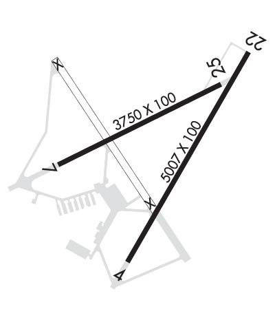
Runway Identifications Help
Runway Identification: 04/22 Length: 5007 ftWidth: 100 ftSurface: ASPHALTEdge lights: High Intensity Treatment: NONE Runway: 04 Runway: 22 Mag heading: 40° Mag heading: 220° Rwy Slope: .05% Up Rwy Slope: -.05% Down Approach: LOC/DME Approach: Pattern: Right Traffic Pattern: Left Traffic Markings: NONPRECISION INSTRUMENT Markings: NONPRECISION INSTRUMENT Marking Condition: GOOD Marking Condition: GOOD Arresting Dev: Arresting Dev: Lat & Long: N3640.6 W07636.1 Lat. & Long.: N3641.3 W07635.6 Elev: 66.3 ft. MSL Elev: 68.8 ft. MSL TCH: 39 ft. AGL TCH: 45 ft. AGL Visual Glide Path: 3.00 degrees Visual Glide Path: 3.50 degrees Displaced Threshold: No Displaced Threshold: No Touchdown Zone: YES Touchdown Zone: YES Touchdown Elev.: 66.3 feet Touchdown Elev.: 68.8 feet Visual Glide Slope: 4-Light PAPI on LEFT side of Runway Visual Glide Slope: 4-Light PAPI on LEFT side of Runway RVR Equipment: RVR Equipment: RVV Equipment: NO RVV Equipment: NO Approach Lights: Approach Lights: REIL: YES REIL: YES Centerline Lights: NO Centerline Lights: NO Touchdown lights: NO Touchdown lights: NO Runway Category: Runway with a Non-precision Approach having visibility minimums greater than 3/4 mile Runway Category: Runway with a Non-precision Approach having visibility minimums greater than 3/4 mile Declared Distances: Declared Distances: Obstructions: TREE Obstructions: TREES Marked: NOT Marked/Lighted Marked: NOT Marked/Lighted Clearance slope: 30:1 Clearance slope: 17:1 Obstruction height: 81 feet AGL Obstruction height: 55 feet AGL Dist. from runway: 2630 feet Dist. from runway: 1155 feet Centerline offset: 425 right of centerline Centerline offset: 388 feet left of centerline Comments: Comments:
Runway Identification: 07/25 Length: 3750 ftWidth: 100 ftSurface: ASPHALT-FAIR CONDITIONEdge lights: Medium Intensity Treatment: NONE Runway: 07 Runway: 25 Mag heading: 74° Mag heading: 254° Rwy Slope: -.04% Down Rwy Slope: .04% Up Approach: Approach: Pattern: Left Traffic Pattern: Right Traffic Markings: NONSTANDARD Markings: NONPRECISION INSTRUMENT Marking Condition: POOR; RWY 7 MARKINGS FADED AND POOR CONDITION. Marking Condition: POOR; RWY 25 MARKINGS IN POOR CONDITION. Arresting Dev: Arresting Dev: Lat & Long: N3640.9 W07636.4 Lat. & Long.: N3641.2 W07635.8 Elev: 68.1 ft. MSL Elev: 66.7 ft. MSL TCH: TCH: Visual Glide Path: Visual Glide Path: Displaced Threshold: No Displaced Threshold: No Touchdown Zone: YES Touchdown Zone: YES Touchdown Elev.: 68.4 feet Touchdown Elev.: 69.1 feet Visual Glide Slope: Visual Glide Slope: RVR Equipment: RVR Equipment: RVV Equipment: NO RVV Equipment: NO Approach Lights: Approach Lights: REIL: NO REIL: NO Centerline Lights: NO Centerline Lights: NO Touchdown lights: NO Touchdown lights: NO Runway Category: Runway with a Non-precision Approach having visibility minimums greater than 3/4 mile Runway Category: Runway with a Non-precision Approach having visibility minimums greater than 3/4 mile Declared Distances: Declared Distances: Obstructions: TREE Obstructions: TREES Marked: NOT Marked/Lighted Marked: NOT Marked/Lighted Clearance slope: 19:1 Clearance slope: 13:1 Obstruction height: 93 feet AGL Obstruction height: 68 feet AGL Dist. from runway: 1985 feet Dist. from runway: 1128 feet Centerline offset: 416 left of centerline Centerline offset: 167 feet left of centerline Comments: Comments: