Click here for more info on on SMS!

KSEM

SOUTHEASTERN AVIATION SERVICES
SELMA
AL
Time Zone: Central
Lat: N 3220.6
Long: W 08659.3
Elev: 166
Var: +03
Longest Runway: 8014
AWOS: 119.15
Ground: 121.67
Tower: 120.85

FBO & Flight Services info for KSEM

FBOs: Update your Fuel Prices

  click here  
Selma, Alabama, rich in civil rights history, is also in the center of the United States, offering a convenient and easily accessible airfield on a former US Air Force Base. Come experience Selma for yourself as we rebuild the air field and offer you affordable and high quality aviation services.
Ph: 334-875-2189 Fax: 334-875-2189 Freq: 122.7WebsiteE-Mail
                     
Service
Jet
100LL
SAF
MoGas
Fuel Avail: JET A INCLUDES PRIST.
Full5.40      Caution: Fuel prices have not been updated in 40 days.
Last Update: 03/09/2024 12:21

Self5.355.65    
Misc. Info: Address: HANGAR 209 CRAIG FIELD   SELMA, AL 36701

AWOSPh: 334-872-9090
-
Freq: 119.15  
If you are an FBO, call 1-203-262-1700 to update your info or email: FltPlan.Advertising@garmin.com
Advertise your FBO on FltPlan.com

Runway & Approach Info for KSEM
Rwy
Length
Land Dist**
Approach*
  Rwy
Length
Land Dist**
Approach*
15
8014x150  8014'          
 
  
33
  8014x150  8014'          
ILS/DME
 110.50 - 328°  
 * only ILS, LOC, LDA, and SDF approaches to a specific runway are shown
** For any Declared Landing Distance Available, please see A/FD or Approach plates
Runway Weight Capability (lbs.) Help
Runway IDSingle WheelDouble WheelDouble Tandem WheelDual Double Wheel
15/3333,00054,000N/AN/A
These numbers are Advisory and are not limits.   The Airport Manager should have more accurate Weight Limits
Approach Charts
Approaches    
Current Weather/Notams
Customs Information Send updates to Support@FltPlan.com
Customs Not Available
Database effective 04/18/2024
Airport Diagram of KSEM
Airport Diagram might not be current.

Facility Name: CRAIG FLD
City Name: SELMA
County: DALLAS
State abbrev: AL
State Name: ALABAMA
   
Ownership: PUBLICLY OWNED
Use: OPEN TO THE PUBLIC
Owner's Name: CRAIG FLD ARPT & IND AUTH; JAMES CORRIGAN, EXECUTIVE DIRECTOR
Address: PO BOX 1421
 SELMA, AL 36702
Owner's Phone: 334-874-7419
  
Manager's Name: DAN LANE
Address: CRAIG FIELD INDUSTRIAL, HANGAR 202, AVENUE J
 SELMA, AL 36701
Phone: 334-419-3881; ALT 334-874-7419.
   
FAA Region: SOUTHERN
FAA Field Office: JAN
2006- Photo courtesy www.AceAerialPhoto.US


Click here for full scale & interactive Sectional view of KSEM


Sunrise / Sunset times for CRAIG FLD

DateSunriseSunset
04/17/24 Wednesday6:1619:20
04/18/24 Thursday6:1419:20
04/19/24 Friday6:1319:21
04/20/24 Saturday6:1219:22
04/21/24 Sunday6:1119:22
04/22/24 Monday6:1019:23
04/23/24 Tuesday6:0919:24
04/24/24 Wednesday6:0819:25
04/25/24 Thursday6:0719:25
04/26/24 Friday6:0619:26
04/27/24 Saturday6:0519:27
04/28/24 Sunday6:0419:27
04/29/24 Monday6:0319:28
04/30/24 Tuesday6:0219:29

Airport Facilities

Airport Attendance Schedule7 Days A Week 0800-1800
Airport Status OPERATIONAL (This Status can change at any time - please check NOTAMS)
Airport Lighting ScheduleWHEN ATCT CLSD ACTVT MALS RWY 33; PAPI RWY 15/33 AND HIRL RWY 15/33 - CTAF.
Airport Storage AvailableTie Downs, Hanger
Extra Services AvailableFlight Instruction
Wind IndicatorYES - (lighted)
Control TowerYES
CTAF Frequency122.700
Unicom Frequency122.700
Rotating Beacon ColorWG
Segmented CircleNO
Landing FeeNO

Airport Inspection Data

Airport InspectedSTATE - performed by STATE AERONAUTICAL PERSONNEL
Inspection Date12/08/2023

Airport Services

Type of Fuel AvailableGrade 100LL, JET A (freeze point -40C); -1024HR 100LL AND JET A AVBL CALL 334-651-1511 AFT HRS.
Airframe Repair ServiceMAJOR
Power Plant Repair ServiceMAJOR

Geographic Data

LatitudeN3220.6
LongitudeW08659.3 (ESTIMATED)
Arpt Elevation166ft (SURVEYED)
Magnetic Variation03W
4 miles SEof SELMA
Traffic Pattern Altitude
Sectional ChartATLANTA

Aircraft Data

Operations (Reported)YearlyAvg. Daily
General Aviation Transient 3200088
General Aviation Local 23006
Air Taxi 2501
Commerical 00
Commuter 00
Military 400011
Aircraft based on Field
General Aviation Singles 15
General Aviation Multi 3
Jet Aircraft 0
General Aviation Helicopters 0
Military Aircraft 0
Gliders 0
Ultralights 0

FAA Services

FSS on field NO
FSS tie-in ANNISTON
FSS Phone 1-800-WX-BRIEF
Who issues Notams ANB
Notam D service at airport YES
ARTCC Name ATLANTA

Federal Status

Airport Certification
Aircraft Rescue & Firefighting IndexNone
Airport of EntryNo
Custom Landing RightsNo
Joint Civil/MilitaryNo
Military Landing rightsYES

Federal Agreements

NATIONAL PLAN OF INTEGRATED AIRPORT SYSTEMS (NPIAS)
GRANT AGREEMENTS UNDER FAAP/ADAP/AIP
SURPLUS PROPERTY AGREEMENT UNDER PUBLIC LAW 289
OBLIGATIONS ASSUMED BY TRANSFER
ASSURANCES PURSUANT TO TITLE VI, CIVIL RIGHTS ACT OF 1964

Remarks

FOR CD IF UNA TO CTC ON FSS FREQ, CTC DANNELLY APCH AT 334-284-4575, WHEN ATCT CLSD CTC ATLANTA ARTCC AT 770-210-7692.
Airport Communications & Frequencies:
CRAIG Tower Frequencies:   Hours(local) of operation: 0700-1900 MON-FRI; 0900-1700 SAT & SUN   
120.85
CRAIG Ground Frequencies:
121.675
CTAF Frequency:
122.700
Unicom Frequency:
122.700
Remarks
  • APCH/DEP SVC PRVDD BY ATLANTA ARTCC ON FREQS 120.55/270.25 (MONTGOMERY RCAG) WHEN MONTGOMERY APCH CTL CLSD.
  • MONTGOMERY Primary Approach Frequencies:  
    124.0
    363.025
    MONTGOMERY Primary Departure Frequencies:  
    124.0
    363.025
    Runway Identifications
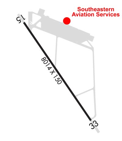
    Runway Identification: 15/33
    Length: 8014 ft
    Width: 150 ft
    Surface: CONCRETE ASPHALT-FAIR CONDITION
    Edge lights: High Intensity

    Treatment: NONE

     Runway: 15   Runway: 33
    Mag heading: 149°Mag heading: 329°
    Rwy Slope: -.01% DownRwy Slope: .01% Up
    Approach: Approach: ILS/DME
    Pattern: Left TrafficPattern: Left Traffic
    Markings: PRECISION INSTRUMENTMarkings: PRECISION INSTRUMENT
    Marking Condition: POOR; RWY ID AND TD MRKGS SEVERELY FADED.Marking Condition: POOR; RWY ID AND TD MRKGS SEVERELY FADED.
    Arresting Dev: Arresting Dev:
    Lat & Long: N3221.2  W08659.7Lat. & Long.: N3220.1  W08658.8
    Elev: 166.2 ft. MSLElev: 165.1 ft. MSL
    TCH: 50 ft. AGLTCH: 56 ft. AGL
    Visual Glide Path: 3.00 degreesVisual Glide Path: 3.00 degrees
    Displaced Threshold: NoDisplaced Threshold: No
    Touchdown Zone: YESTouchdown Zone: YES
    Touchdown Elev.: 166.2 feetTouchdown Elev.: 165.3 feet
    Visual Glide Slope: 4-Light PAPI on LEFT side of RunwayVisual Glide Slope: 4-Light PAPI on LEFT side of Runway
    RVR Equipment: RVR Equipment:
    RVV Equipment: NORVV Equipment: NO
    Approach Lights: Approach Lights: MALS - 1,400 foot medium intensity approach lighting system
    REIL: NOREIL: NO
    Centerline Lights: NOCenterline Lights: NO
    Touchdown lights: NOTouchdown lights: NO
    Runway Category: Runway with a Non-precision Approach having visibility minimums greater than 3/4 mileRunway Category: Precision Instrument Runway
    Declared Distances: Declared Distances:
    Obstructions: TREESObstructions: TREES
    Marked: NOT Marked/LightedMarked: NOT Marked/Lighted
    Clearance slope: 27:1Clearance slope: 34:1
    Obstruction height: 34 feet AGLObstruction height: 70 feet AGL
    Dist. from runway: 1146 feetDist. from runway: 2631 feet
    Centerline offset: 155 left of centerlineCenterline offset: 263 feet right of centerline
    Comments: Comments:
    C:4/P: