Current Weather/Notams (Metars, TAFs, Notams, NWS Forecast, PIREPS, and nearby weather)
Customs Information Send updates to Support@FltPlan.com
Customs Not Available
Database effective 05/16/2024
Airport Diagram might not be current.
|
| Facility Name: | SEBRING RGNL |
| City Name: | SEBRING |
| County: | HIGHLANDS |
| State abbrev: | FL |
| State Name: | FLORIDA |
| | |
| Ownership: | PUBLICLY OWNED |
| Use: | OPEN TO THE PUBLIC |
| Owner's Name: | SEBRING AIRPORT AUTHORITY; CTC PERSON: MIKE WILLINGHAM 863-314-1300 FAX: 863-655-6444 |
| Address: | 128 AUTHORITY LANE |
| | SEBRING, FL 33870 |
| Owner's Phone: | 863-655-6444 |
| | |
| Manager's Name: | SCOTT CARKEET |
| Address: | SEBRING REGIONAL AIRPORT, 128 AUTHORITY LANE |
| | SEBRING, FL 33870 |
| Phone: | 863-314-1319 |
| | |
| FAA Region: | SOUTHERN |
| FAA Field Office: | ORL |
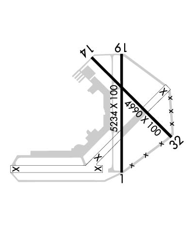
Runway Identifications
Runway Identification: 01/19Length: 5234 ft
Width: 100 ft
Surface: ASPHALT-GOOD CONDITION
Edge lights: Medium IntensityTreatment: NONE
Weight: PCN 32 /F/A/X/T
| | Runway: 01 | | Runway: 19 |
| Mag heading: | 5° | Mag heading: | 185° |
| Rwy Slope: | .05% Up | Rwy Slope: | -.05% Down |
| Approach: | | Approach: | |
| Pattern: | Left Traffic | Pattern: | Left Traffic |
| Markings: | NONPRECISION INSTRUMENT | Markings: | NONPRECISION INSTRUMENT |
| Marking Condition: | FAIR | Marking Condition: | FAIR |
| Arresting Dev: | | Arresting Dev: | |
| Lat & Long: | N2726.9 W08120.6 | Lat. & Long.: | N2727.8 W08120.6 |
| Elev: | 55.9 ft. MSL | Elev: | 58.5 ft. MSL |
| TCH: | 42 ft. AGL | TCH: | 42 ft. AGL |
| Visual Glide Path: | 3.00 degrees | Visual Glide Path: | 3.00 degrees |
| Displaced Threshold: | No | Displaced Threshold: | No |
| Touchdown Zone: | YES | Touchdown Zone: | YES |
| Touchdown Elev.: | 61.6 feet | Touchdown Elev.: | 61.5 feet |
| Visual Glide Slope: | 4-Light PAPI on LEFT side of Runway | Visual Glide Slope: | 4-Light PAPI on LEFT side of Runway; UNUSBL BYD 8 DEGS LEFT AND 7 DEGS RIGHT OF COURSE. |
| RVR Equipment: | | RVR Equipment: | |
| RVV Equipment: | NO | RVV Equipment: | NO |
| Approach Lights: | | Approach Lights: | |
| REIL: | YES | REIL: | YES |
| Centerline Lights: | NO | Centerline Lights: | NO |
| Touchdown lights: | NO | Touchdown lights: | NO |
| Runway Category: | Runway with a Non-precision Approach having visibility minimums greater than 3/4 mile | Runway Category: | Runway with a Non-precision Approach having visibility minimums greater than 3/4 mile |
| Declared Distances: | | Declared Distances: | |
| Obstructions: | TREE | Obstructions: | TREE |
| Marked: | NOT Marked/Lighted | Marked: | NOT Marked/Lighted |
| Clearance slope: | 47:1 | Clearance slope: | 39:1 |
| Obstruction height: | 50 feet AGL | Obstruction height: | 19 feet AGL |
| Dist. from runway: | 2585 feet | Dist. from runway: | 950 feet |
| Centerline offset: | | Centerline offset: | 45 feet right of centerline |
| Comments: | | Comments: | |
Runway Identification: 14/32Length: 4990 ft
Width: 100 ft
Surface: ASPHALT-FAIR CONDITION
Edge lights: Treatment: NONE
Weight: PCN 9 /F/B/Y/T
| | Runway: 14 | | Runway: 32 |
| Mag heading: | 140° | Mag heading: | 320° |
| Rwy Slope: | .07% Up | Rwy Slope: | -.07% Down |
| Approach: | | Approach: | |
| Pattern: | Left Traffic | Pattern: | Left Traffic |
| Markings: | BASIC | Markings: | BASIC |
| Marking Condition: | GOOD | Marking Condition: | GOOD |
| Arresting Dev: | | Arresting Dev: | |
| Lat & Long: | N2727.7 W08120.8 | Lat. & Long.: | N2727.2 W08120.2 |
| Elev: | 53.5 ft. MSL | Elev: | 57.0 ft. MSL |
| TCH: | | TCH: | |
| Visual Glide Path: | | Visual Glide Path: | |
| Displaced Threshold: | 289 feet | Displaced Threshold: | No |
| Touchdown Zone: | YES | Touchdown Zone: | YES |
| Touchdown Elev.: | 60.2 feet | Touchdown Elev.: | 60.2 feet |
| Visual Glide Slope: | | Visual Glide Slope: | |
| RVR Equipment: | | RVR Equipment: | |
| RVV Equipment: | NO | RVV Equipment: | NO |
| Approach Lights: | | Approach Lights: | |
| REIL: | NO | REIL: | NO |
| Centerline Lights: | NO | Centerline Lights: | NO |
| Touchdown lights: | NO | Touchdown lights: | NO |
| Runway Category: | Runway with a Non-precision Approach | Runway Category: | Runway with a Non-precision Approach |
| Declared Distances: | | Declared Distances: | |
| Obstructions: | RR | Obstructions: | FENCE |
| Marked: | NOT Marked/Lighted | Marked: | NOT Marked/Lighted |
| Clearance slope: | 12:1; RWY 14 APCH RATIO 25:1 AT DTHR. | Clearance slope: | 34:1 |
| Obstruction height: | 23 feet AGL | Obstruction height: | 6 feet AGL |
| Dist. from runway: | 486 feet | Dist. from runway: | 408 feet |
| Centerline offset: | | Centerline offset: | |
| Comments: | | Comments: | |


