First Class Facilities - Excellent Service

KSDM

BROWN FIELD MUNI
SAN DIEGO
CA
Time Zone: Pacific
Lat: N 3234.3
Long: W 11658.8
Elev: 526
Var: -14
Longest Runway: 7972
Clr Del: 124.4
Dept. ATIS: 132.35
Arr. ATIS: 132.35
Ground: 124.4
Tower: 128.25

FBO & Flight Services info for KSDM

FBOs: Update your Fuel Prices
First Class Facilities, Volume Fuel Discounts, AvTrip, Crew Cars, Catering, Limo Service, Hotel Discounts, Car Rental, Pilot Lounge with Direct TV and VCR, Snooze Room, Internet Access Hangar and Ramp Space, GPU's, Towing, Cargo Handling, Free Ice and Coffee.
Ph: 619-671-9222
-
Freq: 122.95WebsiteE-Mail
Service
Jet
100LL
SAF
MoGas
Fuel Avail: PRIST PREMIXED, AFTER HOURS AVAILABLE WITH CALLOUT
Full5.956.47    Last Update: 04/23/2024 13:13

Self        
Misc. Info: Address: 1424 CONTINENTAL ST 1   SAN DIEGO, CA 92154
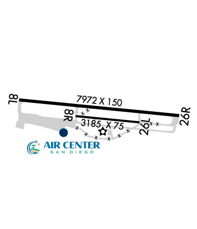
First Flight Corp. offers the best FBO service at Brown Field Airport. Services offered include Flight Training, Aircraft Rental for U.S.A and Mexico, Aircraft Maintenance, Fuel and Ramp Parking.
Ph: 619-661-6522
-
Freq: 122.95WebsiteE-Mail
                   
Service
Jet
100LL
SAF
MoGas
Fuel Avail: PRIST PREMIXED
Full5.25      Last Update: 04/07/2024 09:07

Self  5.59    
Misc. Info: Address: 6810 CURRAN ST   SAN DIEGO, CA 92154

ASOSPh: 619-661-8297
-
-
 
If you are an FBO, call 1-203-262-1700 to update your info or email: FltPlan.Advertising@garmin.com
Advertise your FBO on FltPlan.com

Runway & Approach Info for KSDM
Rwy
Length
Land Dist**
Approach*
  Rwy
Length
Land Dist**
Approach*
08L
7972x150  7972'          
 
  
26R
  7972x150  7972'          
 
08R
3185x75  3185'          
 
  
26L
  3185x75  3185'          
 
 * only ILS, LOC, LDA, and SDF approaches to a specific runway are shown
** For any Declared Landing Distance Available, please see A/FD or Approach plates
Runway Weight Capability (lbs.) Help
Runway IDSingle WheelDouble WheelDouble Tandem WheelDual Double Wheel
08L/26R107,000141,000213,000N/A
08R/26L12,500N/AN/AN/A
These numbers are Advisory and are not limits.   The Airport Manager should have more accurate Weight Limits
Approach Charts
Approaches    
Current Weather/Notams
Customs Information Send updates to Support@FltPlan.com
Phone 619-491-2620
Fax 619-671-9220

Comments Mon-Fri 0800-1630 1 hr advance notice required before entering U.S. Airspace *Maximum passengers per flight: 30 *After hours emergency call 619-690-8888
Database effective 05/16/2024
Airport Diagram of KSDM
Airport Diagram might not be current.

Facility Name: BROWN FLD MUNI
City Name: SAN DIEGO
County: SAN DIEGO
State abbrev: CA
State Name: CALIFORNIA
   
Ownership: PUBLICLY OWNED
Use: OPEN TO THE PUBLIC
Owner's Name: CITY OF SAN DIEGO
Address: 1424 CONTINENTAL ST
 SAN DIEGO, CA 92154
Owner's Phone: 619-424-0455
  
Manager's Name: ANDY SCHWARTZ
Address: 1424 CONTINENTAL ST
 SAN DIEGO, CA 92154
Phone: 619-424-0456
   
FAA Region: WESTERN-PACIFIC
FAA Field Office: LAX


Sunrise / Sunset times for BROWN FLD MUNI

DateSunriseSunset
04/23/24 Tuesday6:0819:24
04/24/24 Wednesday6:0719:25
04/25/24 Thursday6:0619:26
04/26/24 Friday6:0519:26
04/27/24 Saturday6:0419:27
04/28/24 Sunday6:0319:28
04/29/24 Monday6:0219:29
04/30/24 Tuesday6:0119:29
05/01/24 Wednesday6:0019:30
05/02/24 Thursday5:5919:31
05/03/24 Friday5:5819:31
05/04/24 Saturday5:5719:32
05/05/24 Sunday5:5719:33
05/06/24 Monday5:5619:34

Airport Facilities

Airport Attendance Schedule7 Days A Week 0900-1700
Airport Status OPERATIONAL (This Status can change at any time - please check NOTAMS)
Airport Lighting ScheduleACTVT REIL RWY 08L, PAPI RWY 08L & RWY 26R, HIRL RWY 08L/26R, AND MIRL RWY 08R/26L - CTAF.
Airport Storage AvailableTie Downs
Extra Services AvailableAir Freight, Avionics, Cargo Handling, Charter, Flight Instruction, Parachute Jumping, Aircraft Rental, Aircraft Sales
Wind IndicatorYES - (lighted)
Control TowerYES
CTAF Frequency128.250
Unicom Frequency122.950
Rotating Beacon ColorWG
Segmented CircleYES
Landing FeeNO

Airport Inspection Data

Airport InspectedSTATE - performed by STATE AERONAUTICAL PERSONNEL
Inspection Date03/19/2024

Airport Services

Type of Fuel AvailableGrade 100LL, JET A (freeze point -40C), JET A; -10FOR FUEL AFT HRS CALL FBO'S AT (619) 671-9222; FEE FOR CALLOUT. MILITARY FUEL AVBL BY CALLING (619) 671-9222.
Airframe Repair ServiceMAJOR
Power Plant Repair ServiceMAJOR

Geographic Data

LatitudeN3234.3
LongitudeW11658.8 (ESTIMATED)
Arpt Elevation526ft (SURVEYED)
Magnetic Variation14E
13 miles SEof SAN DIEGO
Traffic Pattern Altitude
Sectional ChartLOS ANGELES

Aircraft Data

Operations (Reported)YearlyAvg. Daily
General Aviation Transient 3348892
General Aviation Local 53761147
Air Taxi 25337
Commerical 490
Commuter 00
Military 24247
Aircraft based on Field
General Aviation Singles 119
General Aviation Multi 19
Jet Aircraft 10
General Aviation Helicopters 4
Military Aircraft 0
Gliders 0
Ultralights 0

FAA Services

FSS on field NO
FSS tie-in SAN DIEGO
FSS Phone 1-800-WX-BRIEF
Who issues Notams SDM
Notam D service at airport YES
ARTCC Name LOS ANGELES

Federal Status

Airport Certification
Aircraft Rescue & Firefighting IndexNone
Airport of EntryNo
Custom Landing RightsYES
Joint Civil/MilitaryNo
Military Landing rightsYES

Federal Agreements

NATIONAL PLAN OF INTEGRATED AIRPORT SYSTEMS (NPIAS)
GRANT AGREEMENTS UNDER FAAP/ADAP/AIP
SURPLUS PROPERTY AGREEMENT UNDER PUBLIC LAW 289
ASSURANCES PURSUANT TO TITLE VI, CIVIL RIGHTS ACT OF 1964

Remarks

BE ALERT TO ARPT BDRY ONE MILE NORTH FM MEXICAN/USA INTL BORDER.
PARA JUMPING ON AIRPORT AND 3 MILES EAST.
BE ALERT TO HIGH TERRAIN 3,566 FT. MSL SIX MILES EAST OF AIRPORT.
BE ALERT WHEN DEPARTING ON RY 08L AT NIGHT DUE TO RISING TERRAIN TO THE EAST.
NOISE SENSITIVE AREAS APPROX 1 MILE WEST OF AIRPORT, 1/2 MILE NORTHWEST, AND 2 MILES NORTH.
TWY G WEST OF TWY B RESTRICTED TO AIRCRAFT WITH WINGSPANS OF 133 FT OR LESS.
AVOID DCT OVERFLIGHT OF PIO PICO ENERGY CENTER BLO 2000 FT AGL, 3 NM EAST OF AP.
FOR CD WHEN ATCT CLSD CTC SOCAL APCH AT 800-448-3724.
NO ENGINE OPNS ON RAMPS EXCEPT AS NECESSARY FOR ARRIVALS/DEPARTURES.
RWY 08R/ 26LOPERATOR PERMITS ONLY 12500 LBS.
Airport Communications & Frequencies:
ATIS Frequencies:   Hours(local) of Operation: CONTINUOUS
132.35
BROWN Tower Frequencies:   Hours(local) of operation: 0800-2000   
128.25
225.4
BROWN Ground Frequencies:
124.4
Clearance Delivery Frequencies:
124.4
CTAF Frequency:
128.250
Unicom Frequency:
122.950
SOCAL Primary Approach Frequencies:  
124.35
279.625
SOCAL Primary Departure Frequencies:  
125.15
317.55
Class B Frequencies:
124.35 062-109 SAN 14,000 FT & BLW
279.625 062-109 SAN 14,000 FT & BLW
Runway Identifications
Runway Identification: 08L/26R
Length: 7972 ft
Width: 150 ft
Surface: CONCRETE ASPHALT-GOOD CONDITION
Edge lights: High Intensity

Treatment: NONE
Weight: PCN 43 /F/D/X/T

 Runway: 08L   Runway: 26R
Mag heading: 82°Mag heading: 262°
Rwy Slope: -.23% DownRwy Slope: .23% Up
Approach: Approach:
Pattern: Left TrafficPattern: Right Traffic
Markings: NONPRECISION INSTRUMENTMarkings: NONPRECISION INSTRUMENT
Marking Condition: GOODMarking Condition: GOOD
Arresting Dev: Arresting Dev:
Lat & Long: N3234.4  W11659.6Lat. & Long.: N3234.3  W11658.1
Elev: 526.1 ft. MSLElev: 507.7 ft. MSL
TCH: 52 ft. AGLTCH: 73 ft. AGL
Visual Glide Path: 3.00 degreesVisual Glide Path: 4.00 degrees
Displaced Threshold: NoDisplaced Threshold: No
Touchdown Zone: YESTouchdown Zone: YES
Touchdown Elev.: 526.1 feetTouchdown Elev.: 514.0 feet
Visual Glide Slope: 4-Light PAPI on LEFT side of RunwayVisual Glide Slope: 4-Light PAPI on LEFT side of Runway; RWY 26R PAPI UNUSABLE BYD 3 NM.
RVR Equipment: RVR Equipment:
RVV Equipment: NORVV Equipment: NO
Approach Lights: Approach Lights:
REIL: YESREIL: YES
Centerline Lights: NOCenterline Lights: NO
Touchdown lights: NOTouchdown lights: NO
Runway Category: DRunway Category: Runway with a Visual Approach
Declared Distances: Declared Distances:
Runway Identification: 08R/26L
Length: 3185 ft
Width: 75 ft
Surface: ASPHALT-GOOD CONDITION
Edge lights: Medium Intensity

Treatment: NONE
Weight: PCN 5 /F/D/Z/U

 Runway: 08R   Runway: 26L
Mag heading: 82°Mag heading: 262°
Rwy Slope: -.44% DownRwy Slope: .44% Up
Approach: Approach:
Pattern: Right TrafficPattern: Left Traffic
Markings: BASICMarkings: BASIC
Marking Condition: GOODMarking Condition: GOOD
Arresting Dev: Arresting Dev:
Lat & Long: N3234.3  W11659.1Lat. & Long.: N3234.2  W11658.4
Elev: 520.8 ft. MSLElev: 506.8 ft. MSL
TCH: TCH:
Visual Glide Path: Visual Glide Path:
Displaced Threshold: NoDisplaced Threshold: No
Touchdown Zone: YESTouchdown Zone: YES
Touchdown Elev.: 520.8 feetTouchdown Elev.: 519.2 feet
Visual Glide Slope: Visual Glide Slope:
RVR Equipment: RVR Equipment:
RVV Equipment: NORVV Equipment: NO
Approach Lights: Approach Lights:
REIL: NOREIL: NO
Centerline Lights: NOCenterline Lights: NO
Touchdown lights: NOTouchdown lights: NO
Runway Category: Runway with a Visual ApproachRunway Category: Runway with a Visual Approach
Declared Distances: Declared Distances:
C:98/P: