Click here for more info on on SMS!

KSCX

SCOTT MUNI
ONEIDA
TN
Time Zone: Eastern
Lat: N 3627.3
Long: W 08435.1
Elev: 1545
Var: +05
Longest Runway: 5505
AWOS: 135.02
CTAF: 122.8

FBO & Flight Services info for KSCX

FBOs: Update your Fuel Prices

SCOTT CO ARPTPh: 423-569-8270 Fax: 423-569-8271 Freq: 122.8
Service
Jet
100LL
SAF
MoGas
Fuel Avail: self - serve 24 hours 7 days week :full - serve mon - sat 8:00 am - 6:00 pm sun 12:00 - 6:00 pm
Full5.205.65    Last Update: 04/15/2024 09:58

Self5.155.60    
 Address: 2263 AIRPORT RD   ONEIDA, TN 37841
AWOSPh: 423-569-6651
-
Freq: 135.02  
If you are an FBO, call 1-203-262-1700 to update your info or email: FltPlan.Advertising@garmin.com
Advertise your FBO on FltPlan.com

Runway & Approach Info for KSCX
Rwy
Length
Land Dist**
Approach*
  Rwy
Length
Land Dist**
Approach*
05
5505x75  5505'          
 
  
23
  5505x75  5505'          
SDF
 110.50 - 231°  
 * only ILS, LOC, LDA, and SDF approaches to a specific runway are shown
** For any Declared Landing Distance Available, please see A/FD or Approach plates
Runway Weight Capability (lbs.) Help
Runway IDSingle WheelDouble WheelDouble Tandem WheelDual Double Wheel
05/2328,00040,000N/AN/A
These numbers are Advisory and are not limits.   The Airport Manager should have more accurate Weight Limits
Approach Charts
Approaches    
Current Weather/Notams
Customs Information Send updates to Support@FltPlan.com
Customs Not Available
Database effective 05/16/2024
Airport Diagram of KSCX
Airport Diagram might not be current.

Facility Name: SCOTT MUNI
City Name: ONEIDA
County: SCOTT
State abbrev: TN
State Name: TENNESSEE
   
Ownership: PUBLICLY OWNED
Use: OPEN TO THE PUBLIC
Owner's Name: SCOTT COUNTY
Address: 210 COURT STREET
 HUNTSVILLE, TN 37756
Owner's Phone: 423-663-2000
  
Manager's Name: HANK DUVALL
Address: 2263 AIRPORT RD
 ONEIDA, TN 37841
Phone: 423-569-8270
   
FAA Region: SOUTHERN
FAA Field Office: MEM


Sunrise / Sunset times for SCOTT MUNI

DateSunriseSunset
04/24/24 Wednesday6:5220:21
04/25/24 Thursday6:5120:22
04/26/24 Friday6:5020:23
04/27/24 Saturday6:4920:24
04/28/24 Sunday6:4820:24
04/29/24 Monday6:4620:25
04/30/24 Tuesday6:4520:26
05/01/24 Wednesday6:4420:27
05/02/24 Thursday6:4320:28
05/03/24 Friday6:4220:29
05/04/24 Saturday6:4120:30
05/05/24 Sunday6:4020:31
05/06/24 Monday6:3920:31
05/07/24 Tuesday6:3820:32

Airport Facilities

Airport Attendance ScheduleMON-SAT 0800-1800, SUN 1230-1800; UNATNDD THANKSGIVING & CHRISTMAS.
Airport Status OPERATIONAL (This Status can change at any time - please check NOTAMS)
Airport Lighting ScheduleACTVT ODALS RWY 23; REIL RWY 5 & 23; MIRL RWY 05/23 - CTAF. MIRL RWY 05/23 PRESET LOW INTST; INCR INTST - CTAF. PAPI RWY 05 & 23 OPR CONSLY.
Airport Storage AvailableTie Downs, Hanger
Extra Services AvailableNONE
Wind IndicatorYES - (lighted)
Control TowerNO
CTAF Frequency122.800
Unicom Frequency122.800
Rotating Beacon ColorWG
Segmented CircleYES
Landing FeeNO

Airport Inspection Data

Airport InspectedSTATE - performed by STATE AERONAUTICAL PERSONNEL
Inspection Date07/28/2021

Airport Services

Type of Fuel AvailableGrade 100LL, JET A; -10FUEL 24 HR CREDIT CARD SVC AVBL.
Airframe Repair ServiceMAJOR
Power Plant Repair ServiceMAJOR

Geographic Data

LatitudeN3627.3
LongitudeW08435.1 (ESTIMATED)
Arpt Elevation1544ft (SURVEYED)
Magnetic Variation05W
4 miles SWof ONEIDA
Traffic Pattern Altitude
Sectional ChartCINCINNATI

Aircraft Data

Operations (Reported)YearlyAvg. Daily
General Aviation Transient 15334
General Aviation Local 438012
Air Taxi 500
Commerical 00
Commuter 00
Military 3651
Aircraft based on Field
General Aviation Singles 20
General Aviation Multi 10
Jet Aircraft 8
General Aviation Helicopters 0
Military Aircraft 0
Gliders 0
Ultralights 0

FAA Services

FSS on field NO
FSS tie-in NASHVILLE
FSS Phone 1-800-WX-BRIEF
Who issues Notams BNA
Notam D service at airport YES
ARTCC Name INDIANAPOLIS

Federal Status

Airport Certification
Aircraft Rescue & Firefighting IndexNone
Airport of EntryNo
Custom Landing RightsNo
Joint Civil/MilitaryNo
Military Landing rightsYES

Federal Agreements

NATIONAL PLAN OF INTEGRATED AIRPORT SYSTEMS (NPIAS)
GRANT AGREEMENTS UNDER FAAP/ADAP/AIP
ASSURANCES PURSUANT TO TITLE VI, CIVIL RIGHTS ACT OF 1964

Remarks

WILDLIFE ON & INVOF ARPT.
FOR CD CTC INDIANAPOLIS ARTCC AT 317-247-2411.
Airport Communications & Frequencies:
CTAF Frequency:
122.800
Unicom Frequency:
122.800
Remarks
  • APCH/DEP SVC PRVDD BY INDIANAPOLIS ARTCC ON FREQS 124.625/371.925 (LONDON 2 RCAG).
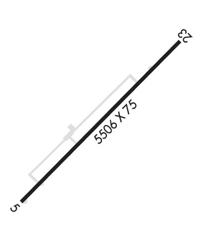
  • Runway Identifications
    Runway Identification: 05/23
    Length: 5505 ft
    Width: 75 ft
    Surface: ASPHALT-FAIR CONDITION
    Edge lights: Medium Intensity

    Treatment: NONE
    Weight: PCN 7 /F/C/X/T

     Runway: 05   Runway: 23
    Mag heading: 51°Mag heading: 231°
    Rwy Slope: -.42% DownRwy Slope: .42% Up
    Approach: Approach: SDF
    Pattern: Left TrafficPattern: Left Traffic
    Markings: NONPRECISION INSTRUMENTMarkings: NONPRECISION INSTRUMENT
    Marking Condition: FAIRMarking Condition: FAIR
    Arresting Dev: Arresting Dev:
    Lat & Long: N3627.0  W08435.6Lat. & Long.: N3627.7  W08434.7
    Elev: 1544.8 ft. MSLElev: 1521.9 ft. MSL
    TCH: 44 ft. AGLTCH: 42 ft. AGL
    Visual Glide Path: 3.50 degreesVisual Glide Path: 3.00 degrees
    Displaced Threshold: NoDisplaced Threshold: No
    Touchdown Zone: YESTouchdown Zone: YES
    Touchdown Elev.: 1544.8 feetTouchdown Elev.: 1522.9 feet
    Visual Glide Slope: 4-Light PAPI on LEFT side of RunwayVisual Glide Slope: 4-Light PAPI on LEFT side of Runway
    RVR Equipment: RVR Equipment:
    RVV Equipment: NORVV Equipment: NO
    Approach Lights: Approach Lights: ODALS - omnidirectional approach lighting system
    REIL: YESREIL: YES
    Centerline Lights: NOCenterline Lights: NO
    Touchdown lights: NOTouchdown lights: NO
    Runway Category: Runway with a Non-precision Approach having visibility minimums greater than 3/4 mileRunway Category: Runway with a Non-precision Approach having visibility minimums greater than 3/4 mile
    Declared Distances: Declared Distances:
    Obstructions: TREESObstructions: TREES
    Marked: NOT Marked/LightedMarked: NOT Marked/Lighted
    Clearance slope: 21:1Clearance slope: 31:1
    Obstruction height: 115 feet AGLObstruction height: 92 feet AGL
    Dist. from runway: 2670 feetDist. from runway: 3053 feet
    Centerline offset: 243 right of centerlineCenterline offset: 442 feet left of centerline
    Comments: Comments:
    C:10/P: