Click here for more info on on SMS!

KSCH

SCHENECTADY COUNTY
SCHENECTADY
NY
Time Zone: Eastern
Lat: N 4251.2
Long: W 07355.8
Elev: 378
Var: +14
Longest Runway: 7001
AWOS: 119.27
Ground: 121.9
Tower: 121.3

FBO & Flight Services info for KSCH

FBOs: Update your Fuel Prices
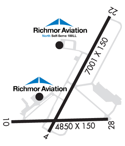
Richmor Aviation has discounts on local hotels. We have rental cars available on the field. Come see our newly expanded ramp (July 13). KSCH boasts a 7000X150 ft runway with ILS. Volume fuel discounts available. Ask about our new corporate hangar!
Ph: 518-399-8171 Fax: 518-399-8192 Freq: 122.95WebsiteE-Mail
                     
Service
Jet
100LL
SAF
MoGas
Fuel Avail: Prist+ $0.02. 8am-8pm Mon-Fri. 8am-8pm weekends. After hrs support call Dave 838-839-1426
Full5.896.39    Last Update: 04/02/2024 09:19

Self  5.89    
Misc. Info: volume discounts, Epic Card discounts.UVAIR fuel.Saratoga Track Specials/giveaways.Address: 19 AIRPORT RD,   SCHENECTADY, NY 12302

AWOSPh: 518-399-6586
-
Freq: 119.27  
If you are an FBO, call 1-203-262-1700 to update your info or email: FltPlan.Advertising@garmin.com
Advertise your FBO on FltPlan.com

Runway & Approach Info for KSCH
Rwy
Length
Land Dist**
Approach*
  Rwy
Length
Land Dist**
Approach*
04
7001x150  7001'          
ILS
 109.70 - 039°  
  
22
  7001x150  7001'          
 
10
4850x150  4650'          
 
  
28
  4850x150  4850'          
 
 * only ILS, LOC, LDA, and SDF approaches to a specific runway are shown
** For any Declared Landing Distance Available, please see A/FD or Approach plates
Runway Weight Capability (lbs.) Help
Runway IDSingle WheelDouble WheelDouble Tandem WheelDual Double Wheel
04/2295,000175,000348,000850,000
10/2855,000134,000218,000541,000
These numbers are Advisory and are not limits.   The Airport Manager should have more accurate Weight Limits
Approach Charts
Approaches    
Current Weather/Notams
Customs Information Send updates to Support@FltPlan.com
Phone 518-431-0200
Fax N/A

Comments 2 hrs advance notice required. *Cargo coverage upon prior arrangement *Call prior to 1500 on preceding weekday. **After hours call 800-973-2867.
Database effective 04/18/2024
Airport Diagram of KSCH
Airport Diagram might not be current.

Facility Name: SCHENECTADY COUNTY
City Name: SCHENECTADY
County: SCHENECTADY
State abbrev: NY
State Name: NEW YORK
   
Ownership: PUBLICLY OWNED
Use: OPEN TO THE PUBLIC
Owner's Name: SCHENECTADY COUNTY
Address: COUNTY OFFICE BLDG
 SCHENECTADY, NY 12305-2114
Owner's Phone: 518-356-5344
  
Manager's Name: MICHAEL SHADEWALD
Address: 21 TOWER ROAD
 SCOTIA, NY 12302-3487
Phone: (518) 399-0111
   
FAA Region: EASTERN
FAA Field Office: NYC


Sunrise / Sunset times for SCHENECTADY COUNTY

DateSunriseSunset
04/18/24 Thursday6:0819:42
04/19/24 Friday6:0719:44
04/20/24 Saturday6:0519:45
04/21/24 Sunday6:0319:46
04/22/24 Monday6:0219:47
04/23/24 Tuesday6:0019:48
04/24/24 Wednesday5:5919:49
04/25/24 Thursday5:5719:50
04/26/24 Friday5:5619:52
04/27/24 Saturday5:5419:53
04/28/24 Sunday5:5319:54
04/29/24 Monday5:5219:55
04/30/24 Tuesday5:5019:56
05/01/24 Wednesday5:4919:57

Airport Facilities

Airport Attendance Schedule7 Days A Week 0730-2230
Airport Status OPERATIONAL (This Status can change at any time - please check NOTAMS)
Airport Lighting ScheduleWHEN ATCT CLSD, ACTVT MALSR RWY 04; PAPI RWY 04, 10, 22 & 28; HIRL RWY 04/22; MIRL RWY 10/28 - CTAF.
Airport Storage AvailableTie Downs, Hanger
Extra Services AvailableAir Freight, Air Ambulance, Avionics, Cargo Handling, Charter, Flight Instruction, Aircraft Rental, Aircraft Sales, Annual Surveying
Wind IndicatorYES - (lighted)
Control TowerYES
CTAF Frequency121.300
Unicom Frequency122.950; USE 122.95 FOR SVC FM FBO
Rotating Beacon ColorWG
Segmented CircleNO
Landing FeeYES

Airport Inspection Data

Airport InspectedSTATE - performed by STATE AERONAUTICAL PERSONNEL
Inspection Date08/18/2022

Airport Services

Type of Fuel AvailableGrade 100LL, JET A (freeze point -40C)
Airframe Repair ServiceMINOR
Power Plant Repair ServiceMAJOR

Geographic Data

LatitudeN4251.2
LongitudeW07355.8 (ESTIMATED)
Arpt Elevation377ft (SURVEYED)
Magnetic Variation14W
3 miles Nof SCHENECTADY
Traffic Pattern Altitude
Sectional ChartNEW YORK

Aircraft Data

Operations (Reported)YearlyAvg. Daily
General Aviation Transient 1477740
General Aviation Local 2926680
Air Taxi 11333
Commerical 00
Commuter 00
Military 382010
Aircraft based on Field
General Aviation Singles 72
General Aviation Multi 8
Jet Aircraft 9
General Aviation Helicopters 0
Military Aircraft 0
Gliders 0
Ultralights 0

FAA Services

FSS on field NO
FSS tie-in BURLINGTON
FSS Phone 1-800-WX-BRIEF
Who issues Notams SCH
Notam D service at airport YES
ARTCC Name BOSTON

Federal Status

Airport Certification
Aircraft Rescue & Firefighting IndexNone
Airport of EntryNo
Custom Landing RightsYES
Joint Civil/MilitaryNo
Military Landing rightsYES

Federal Agreements

NATIONAL PLAN OF INTEGRATED AIRPORT SYSTEMS (NPIAS)
GRANT AGREEMENTS UNDER FAAP/ADAP/AIP
ASSURANCES PURSUANT TO TITLE VI, CIVIL RIGHTS ACT OF 1964
AGREEMENT UNDER DLAND OR DCLA HAS EXPIRED.

Remarks

LANDING FEE FOR INTINRNT MULTI-ENGINE ACFT REQUESTING TWR SVC 0330Z-1230Z.
MILITARY: ANG APRON: ORANGE DASHED WINGTIP CLNC LINES BOTH SIDES OF YELLOW CENTER TAXILINE. DASHED WINGTIP LINES PROVIDE POSITIVE, CLEARLY IDENTIFIABLE OBST CLNC FOR TAXIING ACFT. ANY OBJECT PARKED ON BACK SIDE OF LINES PROVIDE NO WINGTIP CLNC ISSUE.
NO ULTRA-LIGHT OPERATONS IN CLASS D AIRSPACE WITHOUT APPROV FM ATCT.
FLT NOTIFICATION SVC (ADCUS) AVBL.
FUEL: A++ (MIL).
FOR CD CTC ALBANY APCH AT 518-862-2299.
MILITARY: ANG: OPR 1030-2000Z++ MON-FRI, CLSD WKND AND FED HOL. SCHENECTADY COUNTY AIRPORT FONE NR (518)399-0377. COMSEC STORAGE AVBL FOR TRAN CREWS.
MILITARY: CSTMS/AGG/IMG: 1300-2100Z++ MON-FRI, FONE PRIOR 2000Z++ PRECEDING WKD, C518-431-0200, C800-973-2867.
NO UPDATED FIELD OR BRAKING ACTION REPORTS AVBL BTN 0330Z-1230Z.
60 FT DROPOFF 150 FT FM RY 28 END.
NOISE ABATEMENT PROC IN EFFECT FOR LRGE ACFT REMAINING IN PATTERN CTC AIRFIELD MANAGER FOR DETAILS..
BIRDS ON & INVOF ARPT.
MILITARY C130 PATTERN OPERATIONS CONDUCTED DAILY.
MILITARY: ANG: PPR BASE OPS DURG DUTY HR DSN 344-2621, C518-344-2621; OT COMD POST DSN 344-2420, C518-344-2420.
MILITARY: CAUTION: BASH PHASE II PERIOD (15 MAR-15 MAY) AND (1 JUL-15 NOV). BIRD WATCH COND (BWC) SVR: TKOFF, LDG & LCL TRNG PROH UNLESS MSN ESTNL; BWC MDT: MULT APCH PROH, DEP & FULL-STOP ALLOWED IF RTE AVOIDS BIRD ACT; CTC ANG AFLD OPS (CALL-SIGN "SKIER OPS") FOR CURRENT BWC.
Airport Communications & Frequencies:
SCHENECTADY Tower Frequencies:   Hours(local) of operation: 0730-2230 MON-FRI; 0730-2100 WKNDS AND HOLS; CLSD THANKSGIVING & CHRISTMAS; OTR TIMES BY NOTAM.   
121.3
257.8R
291.6R
307.2R
321.1
343.7R
352.0R
378.8R
SCHENECTADY Ground Frequencies:
121.9
Emergency Frequencies:
121.5
243.0
CTAF Frequency:
121.300
Unicom Frequency:
122.950; USE 122.95 FOR SVC FM FBO
ALBANY Primary Approach Frequencies:  
132.825
263.075
ALBANY Primary Departure Frequencies:  
132.825
263.075
Runway Identifications
Runway Identification: 04/22
Length: 7001 ft
Width: 150 ft
Surface: ASPHALT
Edge lights: High Intensity

Treatment: GROOVED
Weight: PCN 49 /F/C/X/T

 Runway: 04   Runway: 22
Mag heading: 40°Mag heading: 220°
Rwy Slope: .85% UpRwy Slope: -.85% Down
Approach: ILSApproach:
Pattern: Left TrafficPattern: Left Traffic
Markings: PRECISION INSTRUMENTMarkings: NONPRECISION INSTRUMENT
Marking Condition: GOODMarking Condition: GOOD
Arresting Dev: Arresting Dev:
Lat & Long: N4250.8  W07356.0Lat. & Long.: N4251.8  W07355.3
Elev: 318.4 ft. MSLElev: 377.9 ft. MSL
TCH: 51 ft. AGLTCH: 50 ft. AGL
Visual Glide Path: 3.00 degreesVisual Glide Path: 3.00 degrees
Displaced Threshold: NoDisplaced Threshold: No
Touchdown Zone: YESTouchdown Zone: YES
Touchdown Elev.: 338.0 feetTouchdown Elev.: 377.9 feet
Visual Glide Slope: 4-Light PAPI on LEFT side of RunwayVisual Glide Slope: 4-Light PAPI on LEFT side of Runway
RVR Equipment: RVR Equipment:
RVV Equipment: NORVV Equipment: NO
Approach Lights: MALSR - 1,400 foot medium intensity approach lighting system with runway alignment indicator lightsApproach Lights:
REIL: NOREIL: NO
Centerline Lights: NOCenterline Lights: NO
Touchdown lights: NOTouchdown lights: NO
Runway Category: Precision Instrument RunwayRunway Category: D
Declared Distances: Declared Distances:
Obstructions: TREESObstructions: GND
Marked: NOT Marked/LightedMarked: NOT Marked/Lighted
Clearance slope: 36:1Clearance slope:
Obstruction height: 28 feet AGLObstruction height: 22 feet AGL
Dist. from runway: 1222 feetDist. from runway: 200 feet
Centerline offset: 477 right of centerlineCenterline offset: 500 feet right of centerline
Comments: Comments: RWY 22 +22FT RISING TERRAIN, 500 FT RT, 0 - 200 FT FM RWY.
Runway Identification: 10/28
Length: 4850 ft
Width: 150 ft
Surface: ASPHALT-GOOD CONDITION
Edge lights: Medium Intensity

Treatment: GROOVED
Weight: PCN 36 /F/C/X/T

 Runway: 10   Runway: 28
Mag heading: 102°Mag heading: 282°
Rwy Slope: -.10% DownRwy Slope: .10% Up
Approach: Approach:
Pattern: Left TrafficPattern: Left Traffic
Markings: NONPRECISION INSTRUMENTMarkings: NONPRECISION INSTRUMENT
Marking Condition: GOODMarking Condition: GOOD
Arresting Dev: Arresting Dev:
Lat & Long: N4250.9  W07356.4Lat. & Long.: N4250.9  W07355.4
Elev: 324.8 ft. MSLElev: 319.9 ft. MSL
TCH: 50 ft. AGLTCH: 50 ft. AGL
Visual Glide Path: 4.00 degreesVisual Glide Path: 3.00 degrees
Displaced Threshold: 200 feetDisplaced Threshold: No
Touchdown Zone: YESTouchdown Zone: YES
Touchdown Elev.: 325.0 feetTouchdown Elev.: 323.0 feet
Visual Glide Slope: 2-Light PAPI on LEFT side of RunwayVisual Glide Slope: 2-Light PAPI on LEFT side of Runway
RVR Equipment: RVR Equipment:
RVV Equipment: NORVV Equipment: NO
Approach Lights: Approach Lights:
REIL: NOREIL: YES
Centerline Lights: NOCenterline Lights: NO
Touchdown lights: NOTouchdown lights: NO
Runway Category: Runway with a Non-precision Approach having visibility minimums greater than 3/4 mileRunway Category: Runway with a Non-precision Approach having visibility minimums greater than 3/4 mile
Declared Distances: Declared Distances:
Obstructions: ROADObstructions: TREES
Marked: NOT Marked/LightedMarked: NOT Marked/Lighted
Clearance slope: 2:1; RWY 10 CLNC SLOPE 14:1 TO DTHR DUE TO 87 FT TREE, 1223 FT FM DTHR, 190 FT RT.Clearance slope:
Obstruction height: 7 feet AGLObstruction height: 19 feet AGL
Dist. from runway: 220 feetDist. from runway: 200 feet
Centerline offset: 253 left of centerlineCenterline offset: 230 feet right of centerline
Comments: Comments: RWY 28 +10 FT ROAD, 150 FT - 200 FT FM RWY, 220 FT RT.
C:23/P: