KSBP

Whisper PlateWhisper Track
SAN LUIS COUNTY RGNL
SAN LUIS OBISPO
CA
Time Zone: Pacific
Lat: N 3514.2
Long: W 12038.6
Elev: 212
Var: -15
Longest Runway: 6101
Dept. ATIS: 120.6
Arr. ATIS: 120.6
Ground: 121.6
Tower: 124.0

FBO & Flight Services info for KSBP

FBOs: Update your Fuel Prices

ACI JETPh: 805-782-9722 Fax: 805-542-9279 Freq: 131.17
Service
Jet
100LL
SAF
MoGas
Fuel Avail: 24/7. 0600-2100 (Regular Hours) 2100-0600 (After Hours)
Full6.157.46    Last Update: 04/16/2024 10:02

Self  6.24    
 Address: 4751 AVIADORES WAY,   SAN LUIS OBISPO, CA 93401
PCF AVIATIONPh: 805-783-2359 Fax: 805-783-0100 Freq: 122.85
Service
Jet
100LL
SAF
MoGas
Fuel Avail: NO FUEL AVAILABLE
Full        Last Update: 04/19/2024 00:01:44

Self        
 Address: 985 AIRPORT DRIVE,   SAN LUIS OBISPO, CA 93401
ASOSPh: 805-547-1260
-
-
 
If you are an FBO, call 1-203-262-1700 to update your info or email: FltPlan.Advertising@garmin.com
Advertise your FBO on FltPlan.com

Runway & Approach Info for KSBP
Rwy
Length
Land Dist**
Approach*
  Rwy
Length
Land Dist**
Approach*
07
2500x100  2500'          
 
  
25
  2500x100  2500'          
 
11
6101x150  5301'          
ILS
 109.70 - 109°  
  
29
  6101x150  5600'          
 
 * only ILS, LOC, LDA, and SDF approaches to a specific runway are shown
** For any Declared Landing Distance Available, please see A/FD or Approach plates
Runway Weight Capability (lbs.) Help
Runway IDSingle WheelDouble WheelDouble Tandem WheelDual Double Wheel
07/2512,50012,500N/AN/A
11/29112,000147,000N/AN/A
These numbers are Advisory and are not limits.   The Airport Manager should have more accurate Weight Limits
Approach Charts
Approaches    
Current Weather/Notams
Customs Information Send updates to Support@FltPlan.com
Customs Not Available
Database effective 04/18/2024
Airport Diagram of KSBP
Airport Diagram might not be current.

Facility Name: SAN LUIS OBISPO COUNTY RGNL
City Name: SAN LUIS OBISPO
County: SAN LUIS OBISPO
State abbrev: CA
State Name: CALIFORNIA
   
Ownership: PUBLICLY OWNED
Use: OPEN TO THE PUBLIC
Owner's Name: SAN LUIS OBISPO COUNTY
Address: COUNTY GOVERNMENT CENTER
 SAN LUIS OBISPO, CA 93408
Owner's Phone: (805) 781-5205
  
Manager's Name: COURTNEY JOHNSON; DEPUTY DIR: CRAIG PIPER (805) 781-4376.
Address: 975 AIRPORT DRIVE, SUITE 1
 SAN LUIS OBISPO, CA 93401
Phone: 805-781-5218
   
FAA Region: WESTERN-PACIFIC
FAA Field Office: SFO


Sunrise / Sunset times for SAN LUIS OBISPO COUNTY RGNL

DateSunriseSunset
04/18/24 Thursday6:2519:39
04/19/24 Friday6:2419:39
04/20/24 Saturday6:2319:40
04/21/24 Sunday6:2219:41
04/22/24 Monday6:2119:42
04/23/24 Tuesday6:1919:43
04/24/24 Wednesday6:1819:43
04/25/24 Thursday6:1719:44
04/26/24 Friday6:1619:45
04/27/24 Saturday6:1519:46
04/28/24 Sunday6:1419:47
04/29/24 Monday6:1319:48
04/30/24 Tuesday6:1119:48
05/01/24 Wednesday6:1019:49

Airport Facilities

Airport Attendance Schedule7 Days A Week 0600-1700
Airport Status OPERATIONAL (This Status can change at any time - please check NOTAMS)
Airport Lighting ScheduleACTVT MALSR RWY 11; REIL RWY 29; VASI RWY 11; HIRL RWY 11/29 - CTAF. VASI RWY 29 OPR CONSLY.
Airport Storage AvailableTie Downs
Extra Services AvailableAir Freight, Avionics, Cargo Handling, Charter, Flight Instruction, Aircraft Rental, Aircraft Sales, Annual Surveying
Wind IndicatorYES - (lighted)
Control TowerYES
CTAF Frequency124.000
Unicom Frequency122.950
Rotating Beacon ColorWG
Segmented CircleYES
Landing FeeNO

Airport Inspection Data

Airport InspectedFEDERAL - performed by FAA AIRPORTS FIELD PERSONNEL
Inspection Date02/22/2024

Airport Services

Type of Fuel AvailableGrade 100LL, JET A (freeze point -40C)
Airframe Repair ServiceMAJOR
Power Plant Repair ServiceMAJOR

Geographic Data

LatitudeN3514.2
LongitudeW12038.6 (ESTIMATED)
Arpt Elevation212ft (SURVEYED)
Magnetic Variation15E
3 miles Sof SAN LUIS OBISPO
Traffic Pattern AltitudeTPA 991 AGL SINGLE ENG; 1491 AGL MULTI-ENG, JET & HIGH PER.
Sectional ChartLOS ANGELES

Aircraft Data

Operations (Reported)YearlyAvg. Daily
General Aviation Transient 2489568
General Aviation Local 37054102
Air Taxi 534415
Commerical 748421
Commuter 00
Military 11003
Aircraft based on Field
General Aviation Singles 190
General Aviation Multi 16
Jet Aircraft 14
General Aviation Helicopters 5
Military Aircraft 0
Gliders 0
Ultralights 0

FAA Services

FSS on field NO
FSS tie-in HAWTHORNE
FSS Phone 1-800-WX-BRIEF
Who issues Notams SBP
Notam D service at airport YES
ARTCC Name LOS ANGELES

Federal Status

Airport CertificationAIRPORT RECEIVING SCHEDULED AIR CARRIER SERVICE FROM CARRIERS CERTIFICATED BY THE CIVIL AERONAUTICS BOARD; RWY 7/25 NOT AVBL FOR SKED ACR OPNS WITH MORE THAN 9 PSGR SEATS OR UNSKED ACR AT LEAST 31 PSGR SEATS.
Aircraft Rescue & Firefighting IndexAIRPORT HAS A CERTIFICATE UNDER CFR PART 139
Airport of EntryNo
Custom Landing RightsNo
Joint Civil/MilitaryNo
Military Landing rightsYES

Federal Agreements

NATIONAL PLAN OF INTEGRATED AIRPORT SYSTEMS (NPIAS)
GRANT AGREEMENTS UNDER FAAP/ADAP/AIP
ASSURANCES PURSUANT TO TITLE VI, CIVIL RIGHTS ACT OF 1964

Remarks

RECURRING FLOCKS OF WATERFOWL ON AND IN VICINITY OF ARPT DURG WINTER MONTHS.
TWY A BTN TWYS C AND F WILL BE PDCLY RSTRD FOR ACFT WITH WINGSPAN OF 79 FT OR GTR DRG OPNS ON RWY 11/29.
TAXILANE WIDTHS LESS THAN STANDARD.
NOISE SENSITIVE ARPT; TCH 50 FT; FOR NOISE ABATEMENT INFO CTC AMGR (805) 781-5205.
RY 29 DESIGNATED CALM WIND RY.
ATCT UNABLE TO SEE ACFT IN HOLDING BAY AT NW END OF TWY A. MOVEMENT FM HOLDING BAY REQUIRES ATCT APVL DURG ATCT HRS.
TRANSIENT PARKING EXCEEDING 2 HRS CTC FBO EXCEPT FOR AIR CARRIERS.
PUSHBACK FM TRML GATES AT PILOT'S DISCRETION. DO NOT CALL GND CTL FOR PUSHBACK.
RWY 7/25 NOT AVBL FOR AIR CARRIER USE.
TWY A RUN-UP AREA FOR RWY 29, JETS USE MNM BREAKAWAY PWR.
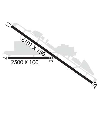
RWY 11/2 9 BLAST PAD DEP END RY 11: 600 FT X 200 FT. BLAST PAD DEP END RY 29: 600 FT X 200 FT.
Airport Communications & Frequencies:
ATIS Frequencies:   Hours(local) of Operation: 0600-2000
120.6
SAN LUIS Tower Frequencies:   Hours(local) of operation: 0600-2000   
124.0
379.9
SAN LUIS Ground Frequencies:
121.6
CTAF Frequency:
124.000
Unicom Frequency:
122.950
Remarks
  • APCH/DEP CTL SVC PRVDD BY LOS ANGELES ARTCC (ZLA) ON FREQS 119.05/269.5 (SAN LUIS OBISPO RCAG) WHEN SANTA BARBARA APCH CTL (SBA) CLSD.
  • SANTA BARBARA Primary Approach Frequencies:  
    127.725
    244.575
    SANTA BARBARA Primary Departure Frequencies:  
    127.725
    244.575
    Runway Identifications
    Runway Identification: 07/25
    Length: 2500 ft
    Width: 100 ft
    Surface: ASPHALT-GOOD CONDITION
    Edge lights:

    Treatment: NONE
    Weight: PCN 25 /F/D/X/T

     Runway: 07   Runway: 25
    Mag heading: 75°Mag heading: 255°
    Rwy Slope: 1.08% UpRwy Slope: -1.08% Down
    Approach: Approach:
    Pattern: Left TrafficPattern: Left Traffic
    Markings: BASICMarkings: BASIC
    Marking Condition: GOODMarking Condition: GOOD
    Arresting Dev: Arresting Dev:
    Lat & Long: N3514.2  W12039.0Lat. & Long.: N3514.2  W12038.5
    Elev: 162.0 ft. MSLElev: 189.0 ft. MSL
    TCH: TCH:
    Visual Glide Path: Visual Glide Path:
    Displaced Threshold: NoDisplaced Threshold: No
    Touchdown Zone: YESTouchdown Zone: YES
    Touchdown Elev.: 189.0 feetTouchdown Elev.: 189.0 feet
    Visual Glide Slope: Visual Glide Slope:
    RVR Equipment: RVR Equipment:
    RVV Equipment: NORVV Equipment: NO
    Approach Lights: Approach Lights:
    REIL: NOREIL: NO
    Centerline Lights: NOCenterline Lights: NO
    Touchdown lights: NOTouchdown lights: NO
    Runway Category: Runway with a Visual ApproachRunway Category: Runway with a Visual Approach
    Declared Distances: TORA:2500' TODA:2500' ASDA:2500' LDA:2500'Declared Distances: TORA:2500' TODA:2500' ASDA:2500' LDA:2500'
    Obstructions: ROADObstructions:
    Marked: NOT Marked/LightedMarked:
    Clearance slope: 21:1Clearance slope: 50:1
    Obstruction height: 10 feet AGLObstruction height:
    Dist. from runway: 410 feetDist. from runway:
    Centerline offset: Centerline offset:
    Comments: Comments:
    Runway Identification: 11/29
    Length: 6101 ft
    Width: 150 ft
    Surface: ASPHALT-GOOD CONDITION
    Edge lights: High Intensity

    Treatment: GROOVED
    Weight: PCN 47 /F/D/X/T

     Runway: 11   Runway: 29
    Mag heading: 110°Mag heading: 290°
    Rwy Slope: .83% UpRwy Slope: -.83% Down
    Approach: ILSApproach:
    Pattern: Left TrafficPattern: Left Traffic
    Markings: PRECISION INSTRUMENTMarkings: NONPRECISION INSTRUMENT
    Marking Condition: GOODMarking Condition: GOOD
    Arresting Dev: EMAS; ENGINEERED MATERIAL ARRESTING SYSTEM (EMAS) 300 FT IN LENGTH BY 170 FT IN WIDTH LCTD AT THE DER 11.Arresting Dev: EMAS; ENGINEERED MATERIAL ARRESTING SYSTEM (EMAS) 312 FT IN LENGTH BY 170 FT IN WIDTH LCTD AT THE DER 29.
    Lat & Long: N3514.5  W12039.0Lat. & Long.: N3514.0  W12038.0
    Elev: 161.8 ft. MSLElev: 212.2 ft. MSL
    TCH: 50 ft. AGLTCH: 50 ft. AGL
    Visual Glide Path: 3.00 degreesVisual Glide Path: 3.25 degrees
    Displaced Threshold: 800 feetDisplaced Threshold: 501 feet
    Touchdown Zone: YESTouchdown Zone: YES
    Touchdown Elev.: 197.8 feetTouchdown Elev.: 211.8 feet
    Visual Glide Slope: 4-BOX VASI ON LEFT SIDE OF RUNWAY; RWY 11 VASI UNUSBL BYD 5 DEGS RIGHT OF RWY CNTRLN.Visual Glide Slope: 4-BOX VASI ON LEFT SIDE OF RUNWAY
    RVR Equipment: RVR Equipment:
    RVV Equipment: NORVV Equipment: NO
    Approach Lights: MALSR - 1,400 foot medium intensity approach lighting system with runway alignment indicator lightsApproach Lights:
    REIL: NOREIL: YES
    Centerline Lights: NOCenterline Lights: NO
    Touchdown lights: NOTouchdown lights: NO
    Runway Category: Precision Instrument RunwayRunway Category: Runway with a Non-precision Approach having visibility minimums greater than 3/4 mile
    Declared Distances: TORA:6100' TODA:6100' ASDA:6100' LDA:5300'Declared Distances: TORA:6100' TODA:6100' ASDA:6100' LDA:5600'
    C:63/P: