
| ||||||||||||||||||||||||||||||||||||||||||||
| ||||||||||||||||||||||||||||||||||||||||||||
| ||||||||||||||||||||||||||||||||||||||||||||
| ||||||||||||||||||||||||||||||||||||||||||||
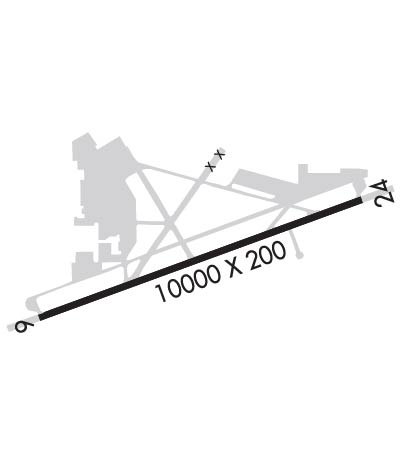
| Rwy | Rwy | |||||||
| 10000x200 | 10000' | 109.30 - 057° | 10000x200 | 10000' | ||||
| Runway ID | Single Wheel | Double Wheel | Double Tandem Wheel | Dual Double Wheel |
| 06/24 | 97,000 | 265,000 | 890,000 | 960,000 |
| These numbers are Advisory and are not limits. The Airport Manager should have more accurate Weight Limits | ||||
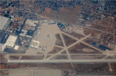
 Airport Diagram might not be current. | |
| Facility Name: | SAN BERNARDINO INTL |
| City Name: | SAN BERNARDINO |
| County: | SAN BERNARDINO |
| State abbrev: | CA |
| State Name: | CALIFORNIA |
| Ownership: | PUBLICLY OWNED |
| Use: | OPEN TO THE PUBLIC |
| Owner's Name: | SAN BERNARDINO INTL AIRPORT AUTH |
| Address: | 1601 E 3RD STREET |
| SAN BERNARDINO, CA 92408 | |
| Owner's Phone: | 909-382-4100 |
| Manager's Name: | MARK GIBBS |
| Address: | 1601 EAST 3RD STREET |
| SAN BERNARDINO, CA 92408 | |
| Phone: | 909-382-4100 |
| FAA Region: | WESTERN-PACIFIC |
| FAA Field Office: | LAX |
| Date | Sunrise | Sunset |
|---|---|---|
| 04/24/24 Wednesday | 6:06 | 19:28 |
| 04/25/24 Thursday | 6:05 | 19:29 |
| 04/26/24 Friday | 6:04 | 19:30 |
| 04/27/24 Saturday | 6:03 | 19:30 |
| 04/28/24 Sunday | 6:02 | 19:31 |
| 04/29/24 Monday | 6:01 | 19:32 |
| 04/30/24 Tuesday | 6:00 | 19:33 |
| 05/01/24 Wednesday | 5:59 | 19:34 |
| 05/02/24 Thursday | 5:58 | 19:34 |
| 05/03/24 Friday | 5:57 | 19:35 |
| 05/04/24 Saturday | 5:56 | 19:36 |
| 05/05/24 Sunday | 5:55 | 19:37 |
| 05/06/24 Monday | 5:54 | 19:37 |
| 05/07/24 Tuesday | 5:53 | 19:38 |
| Airport Attendance Schedule | MON-SUN 0700-2100 |
| Airport Status | OPERATIONAL (This Status can change at any time - please check NOTAMS) |
| Airport Lighting Schedule | WHEN ATCT CLSD HIRL PRESET LOW INTST, TO INCREASE INTST AND ACTVT REILS RYS 06 & 24 ACTVT - CTAF. PAPI RYS 06 AND RY 24 OPER CONTINUOUSLY. |
| Airport Storage Available | Tie Downs |
| Extra Services Available | Air Freight, Avionics, Cargo Handling |
| Wind Indicator | YES - (lighted) |
| Control Tower | YES |
| CTAF Frequency | 119.450 |
| Unicom Frequency | 122.975 |
| Rotating Beacon Color | WG |
| Segmented Circle | YES |
| Landing Fee | YES |
| Airport Inspected | STATE - performed by FAA AIRPORTS FIELD PERSONNEL |
| Inspection Date | 07/26/2023 |
| Type of Fuel Available | Grade 100LL, JET A (freeze point -40C) |
| Airframe Repair Service | MAJOR |
| Power Plant Repair Service | MAJOR |
| Latitude | N3405.7 |
| Longitude | W11714.1 (ESTIMATED) |
| Arpt Elevation | 1159ft (SURVEYED) |
| Magnetic Variation | 13E |
| 2 miles SE | of SAN BERNARDINO |
| Traffic Pattern Altitude | 800 |
| Sectional Chart | LOS ANGELES |
| Operations (Reported) | Yearly | Avg. Daily |
|---|---|---|
| General Aviation Transient | 16867 | 46 |
| General Aviation Local | 18412 | 50 |
| Air Taxi | 8272 | 23 |
| Commerical | 5238 | 14 |
| Commuter | 0 | 0 |
| Military | 228 | 1 |
| Aircraft based on Field | |
|---|---|
| General Aviation Singles | 23 |
| General Aviation Multi | 5 |
| Jet Aircraft | 6 |
| General Aviation Helicopters | 23 |
| Military Aircraft | 0 |
| Gliders | 0 |
| Ultralights | 0 |
| FSS on field | NO |
| FSS tie-in | RIVERSIDE |
| FSS Phone | 1-800-WX-BRIEF |
| Who issues Notams | SBD |
| Notam D service at airport | YES |
| ARTCC Name | LOS ANGELES |
| Airport Certification | |
| Aircraft Rescue & Firefighting Index | AIRPORT HAS A CERTIFICATE UNDER CFR PART 139 |
| Airport of Entry | No |
| Custom Landing Rights | No; US CUSTOMS USER FEE ARPT. |
| Joint Civil/Military | No |
| Military Landing rights | YES |
| NATIONAL PLAN OF INTEGRATED AIRPORT SYSTEMS (NPIAS) |
| GRANT AGREEMENTS UNDER FAAP/ADAP/AIP |
| SURPLUS PROPERTY AGREEMENT UNDER PUBLIC LAW 289 |
| ASSURANCES PURSUANT TO TITLE VI, CIVIL RIGHTS ACT OF 1964 |
| RY 06/24 STRENGTH RATED FOR THE A380 AT 1,300,000 LBS. |
| PERIODIC LIVE FIREFIGHTING TRAINING PRODUCING SMOKE AND LIGHT EMMISIONS APPROX 6,000 FT NE OF RY 6 THLD. |
| ATCT NON VISIBLE AREA ON TWY ALPHA 425 FT WEST OF TWY ALPHA 1. |
| AFTER HOURS GENERAL AVIATION ACCESS AND FUEL AVBL WITH PPR CALL FIXED BASE OPERATORS AT 909-382-6068. |
| AIRFIELD SFC COND NOT MNT BTN THE HRS 2000-0500. |
| TWY A, A1, E, ACFT WINGSPAN MORE THAN 171 FT USE INBOARD ENGS DRG TAX. |
| FOR CD WHEN ATCT CLSD CTC SOCAL APCH AT 800-448-3724. |
| REDLANDS ARPT (REI) 4.5 NM EAST TPA 2500 MSL CTAF/AUNICOM 123.05. AEROBATIC AREA 6.2 NM EAST 3500-7000 MSL. RMN VIGILANT TO SEE AND AVOID. |
| HIGH TERRAIN N AND E OF APT. |
| RY 06 DESIGNATED CALM WIND RY. |
| FIRE FIGHTING ACFT CTC US FOREST SVC TANKER BASE ON GND FREQ 123.975. |
Airport Communications & Frequencies:
| |||||||||||||||||||||||||||||||||||||||||||||||||||||||||
| Runway: 06 | Runway: 24 | ||
| Mag heading: | 57° | Mag heading: | 237° |
| Rwy Slope: | .75% Up | Rwy Slope: | -.75% Down |
| Approach: | ILS | Approach: | |
| Pattern: | Right Traffic | Pattern: | Left Traffic |
| Markings: | PRECISION INSTRUMENT | Markings: | PRECISION INSTRUMENT |
| Marking Condition: | GOOD | Marking Condition: | GOOD |
| Arresting Dev: | Arresting Dev: | ||
| Lat & Long: | N3405.4 W11715.0 | Lat. & Long.: | N3406.0 W11713.2 |
| Elev: | 1084.4 ft. MSL | Elev: | 1159.3 ft. MSL |
| TCH: | 52 ft. AGL | TCH: | 50 ft. AGL |
| Visual Glide Path: | 3.00 degrees | Visual Glide Path: | 3.00 degrees |
| Displaced Threshold: | No | Displaced Threshold: | No |
| Touchdown Zone: | YES | Touchdown Zone: | YES |
| Touchdown Elev.: | 1103.0 feet | Touchdown Elev.: | 1159.3 feet |
| Visual Glide Slope: | 4-Light PAPI on LEFT side of Runway | Visual Glide Slope: | 4-Light PAPI on LEFT side of Runway |
| RVR Equipment: | TOUCHDOWN-MIDFIELD-ROLLOUT | RVR Equipment: | TOUCHDOWN-MIDFIELD-ROLLOUT |
| RVV Equipment: | NO | RVV Equipment: | NO |
| Approach Lights: | Approach Lights: | ||
| REIL: | YES | REIL: | YES |
| Centerline Lights: | NO | Centerline Lights: | NO |
| Touchdown lights: | NO | Touchdown lights: | NO |
| Runway Category: | Precision Instrument Runway | Runway Category: | Runway with a Visual Approach |
| Declared Distances: | TORA:10000' TODA:10000' ASDA:10000' LDA:10000' | Declared Distances: | TORA:10000' TODA:10000' ASDA:10000' LDA:10000' |