Current Weather/Notams (Metars, TAFs, Notams, NWS Forecast, PIREPS, and nearby weather)
Customs Information Send updates to Support@FltPlan.com
Customs Not Available
Database effective 04/18/2024
Airport Diagram might not be current.
|
| Facility Name: | SPARTA COMMUNITY-HUNTER FLD |
| City Name: | SPARTA |
| County: | RANDOLPH |
| State abbrev: | IL |
| State Name: | ILLINOIS |
| | |
| Ownership: | PUBLICLY OWNED |
| Use: | OPEN TO THE PUBLIC |
| Owner's Name: | SPARTA COMM ARPT AUTHORITY |
| Address: | 1800 N. MARKET |
| | SPARTA, IL 62286 |
| Owner's Phone: | 618-443-2002 |
| | |
| Manager's Name: | SCOTT MARQUARDT |
| Address: | 1800 N. MARKET |
| | SPARTA, IL 62286 |
| Phone: | (618) 443-5321 |
| | |
| FAA Region: | GREAT LAKES |
| FAA Field Office: | CHI |
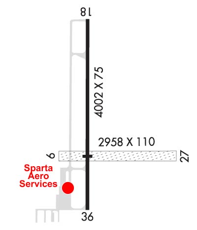
Runway Identifications
Runway Identification: 09/27Length: 2958 ft
Width: 110 ft
Surface: GRASS-GOOD CONDITION
Edge lights: Treatment: NONE
| | Runway: 09 | | Runway: 27 |
| Mag heading: | 90° | Mag heading: | 270° |
| Rwy Slope: | -.44% Down | Rwy Slope: | .44% Up |
| Approach: | | Approach: | |
| Pattern: | Left Traffic | Pattern: | Left Traffic |
| Markings: | | Markings: | |
| Marking Condition: | MARKED WITH WHITE CONES. | Marking Condition: | MARKED WITH WHITE CONES. |
| Arresting Dev: | | Arresting Dev: | |
| Lat & Long: | N3808.9 W08942.1 | Lat. & Long.: | N3808.8 W08941.5 |
| Elev: | 532.5 ft. MSL | Elev: | 519.5 ft. MSL |
| TCH: | | TCH: | |
| Visual Glide Path: | | Visual Glide Path: | |
| Displaced Threshold: | No | Displaced Threshold: | No |
| Touchdown Zone: | YES | Touchdown Zone: | YES |
| Touchdown Elev.: | 532.5 feet | Touchdown Elev.: | 532.5 feet |
| Visual Glide Slope: | | Visual Glide Slope: | |
| RVR Equipment: | | RVR Equipment: | |
| RVV Equipment: | NO | RVV Equipment: | NO |
| Approach Lights: | | Approach Lights: | |
| REIL: | NO | REIL: | NO |
| Centerline Lights: | NO | Centerline Lights: | NO |
| Touchdown lights: | NO | Touchdown lights: | NO |
| Runway Category: | Runway with a Visual Approach | Runway Category: | Runway with a Visual Approach |
| Declared Distances: | | Declared Distances: | |
| Obstructions: | | Obstructions: | TREE |
| Marked: | | Marked: | NOT Marked/Lighted |
| Clearance slope: | 20:1 | Clearance slope: | 20:1 |
| Obstruction height: | | Obstruction height: | 45 feet AGL |
| Dist. from runway: | | Dist. from runway: | 905 feet |
| Centerline offset: | | Centerline offset: | 87 feet left of centerline |
| Comments: | | Comments: | |
Runway Identification: 18/36Length: 4002 ft
Width: 75 ft
Surface: ASPHALT-GOOD CONDITION
Edge lights: Medium IntensityTreatment: NONE
| | Runway: 18 | | Runway: 36 |
| Mag heading: | 179° | Mag heading: | 359° |
| Rwy Slope: | -.37% Down | Rwy Slope: | .37% Up |
| Approach: | | Approach: | |
| Pattern: | Left Traffic | Pattern: | Left Traffic |
| Markings: | NONPRECISION INSTRUMENT | Markings: | NONPRECISION INSTRUMENT |
| Marking Condition: | FAIR | Marking Condition: | FAIR |
| Arresting Dev: | | Arresting Dev: | |
| Lat & Long: | N3809.3 W08942.0 | Lat. & Long.: | N3808.7 W08942.0 |
| Elev: | 537.6 ft. MSL | Elev: | 522.8 ft. MSL |
| TCH: | 20 ft. AGL | TCH: | 24 ft. AGL |
| Visual Glide Path: | 3.00 degrees | Visual Glide Path: | 3.50 degrees |
| Displaced Threshold: | No | Displaced Threshold: | No |
| Touchdown Zone: | YES | Touchdown Zone: | YES |
| Touchdown Elev.: | 537.6 feet | Touchdown Elev.: | 533.4 feet |
| Visual Glide Slope: | 4-Light PAPI on LEFT side of Runway; RY 18 PAPI, UNUSBL BYD 7 DEG LEFT OF COURSE. | Visual Glide Slope: | 4-Light PAPI on LEFT side of Runway |
| RVR Equipment: | | RVR Equipment: | |
| RVV Equipment: | NO | RVV Equipment: | NO |
| Approach Lights: | | Approach Lights: | |
| REIL: | YES | REIL: | NO |
| Centerline Lights: | NO | Centerline Lights: | NO |
| Touchdown lights: | NO | Touchdown lights: | NO |
| Runway Category: | Runway with a Non-precision Approach | Runway Category: | Runway with a Non-precision Approach |
| Declared Distances: | | Declared Distances: | |


