Click here for more info on on SMS!

KS97

ANDERSON FIELD
BREWSTER
WA
Time Zone: Pacific
Lat: N 4806.3
Long: W 11943.2
Elev: 920
Var: -20
Longest Runway: 4000
CTAF: 122.8

FBO & Flight Services info for KS97

FBOs: Update your Fuel Prices

GOLDEN WINGSPh: 509-689-2712
-
Freq: 122.8
Service
Jet
100LL
SAF
MoGas
Fuel Avail: ~~Grade 100LL; FUEL FOR EMERGENCY USE ONLY.SEE CHTR OPR WHO LIVES ON FIELD.
Full        Last Update: 04/22/2024 05:24:32

Self        
If you are an FBO, call 1-203-262-1700 to update your info or email: FltPlan.Advertising@garmin.com
Advertise your FBO on FltPlan.com

Runway & Approach Info for KS97
Rwy
Length
Land Dist**
Approach*
  Rwy
Length
Land Dist**
Approach*
07
4000x60  4000'          
 
  
25
  4000x60  4000'          
 
 * only ILS, LOC, LDA, and SDF approaches to a specific runway are shown
** For any Declared Landing Distance Available, please see A/FD or Approach plates
Runway Weight Capability (lbs.) Help
Runway IDSingle WheelDouble WheelDouble Tandem WheelDual Double Wheel
07/2515,000N/AN/AN/A
These numbers are Advisory and are not limits.   The Airport Manager should have more accurate Weight Limits
Approach Charts
FltPlan does not have IFR approach charts available for KS97.
Current Weather/Notams
Customs Information Send updates to Support@FltPlan.com
Customs Not Available
Database effective 05/16/2024
Airport Diagram of KS97
Airport Diagram might not be current.

Facility Name: ANDERSON FLD
City Name: BREWSTER
County: OKANOGAN
State abbrev: WA
State Name: WASHINGTON
   
Ownership: PUBLICLY OWNED
Use: OPEN TO THE PUBLIC
Owner's Name: CITY OF BREWSTER
Address: BOX 340
 BREWSTER, WA 98812
Owner's Phone: 509-689-3464
  
Manager's Name: LEE WEBSTER
Address: BOX 340
 BREWSTER, WA 98812
Phone: (509) 689-3464
   
FAA Region: NORTHWEST MOUNTAIN
FAA Field Office: SEA


Sunrise / Sunset times for ANDERSON FLD

DateSunriseSunset
04/22/24 Monday5:5520:01
04/23/24 Tuesday5:5320:02
04/24/24 Wednesday5:5120:04
04/25/24 Thursday5:4920:05
04/26/24 Friday5:4720:06
04/27/24 Saturday5:4620:08
04/28/24 Sunday5:4420:09
04/29/24 Monday5:4220:11
04/30/24 Tuesday5:4120:12
05/01/24 Wednesday5:3920:14
05/02/24 Thursday5:3720:15
05/03/24 Friday5:3620:16
05/04/24 Saturday5:3420:18
05/05/24 Sunday5:3320:19

Airport Facilities

Airport Attendance ScheduleUNATTENDED
Airport Status OPERATIONAL (This Status can change at any time - please check NOTAMS)
Airport Lighting ScheduleACTVT MIRL RY 07/25 - CTAF.
Airport Storage AvailableTie Downs
Extra Services AvailableCrop Dusting, Charter, Flight Instruction, Aircraft Rental
Wind IndicatorYES - (lighted)
Control TowerNO
CTAF Frequency122.800
Unicom Frequency122.800
Rotating Beacon ColorWG
Segmented CircleYES
Landing FeeNO

Airport Inspection Data

Airport InspectedSTATE - performed by STATE AERONAUTICAL PERSONNEL
Inspection Date08/24/2021

Airport Services

Type of Fuel AvailableNone
Airframe Repair ServiceNONE
Power Plant Repair ServiceNONE

Geographic Data

LatitudeN4806.3
LongitudeW11943.2 (ESTIMATED)
Arpt Elevation919ft (SURVEYED)
Magnetic Variation20E
3 miles Eof BREWSTER
Traffic Pattern Altitude
Sectional ChartSEATTLE

Aircraft Data

Operations (Reported)YearlyAvg. Daily
General Aviation Transient 930025
General Aviation Local 530015
Air Taxi 00
Commerical 00
Commuter 00
Military 00
Aircraft based on Field
General Aviation Singles 5
General Aviation Multi 2
Jet Aircraft 0
General Aviation Helicopters 19
Military Aircraft 0
Gliders 0
Ultralights 0

FAA Services

FSS on field NO
FSS tie-in SEATTLE
FSS Phone 1-800-WX-BRIEF
Who issues Notams SEA
Notam D service at airport YES
ARTCC Name SEATTLE

Federal Status

Airport Certification
Aircraft Rescue & Firefighting IndexNone
Airport of EntryNo
Custom Landing RightsNo
Joint Civil/MilitaryNo
Military Landing rightsYES

Federal Agreements

NATIONAL PLAN OF INTEGRATED AIRPORT SYSTEMS (NPIAS)
GRANT AGREEMENTS UNDER FAAP/ADAP/AIP
ASSURANCES PURSUANT TO TITLE VI, CIVIL RIGHTS ACT OF 1964

Remarks

TWY LGTS ON CNTR TWY ONLY.
FOR CD CTC SEATTLE ARTCC AT 253-351-3694.
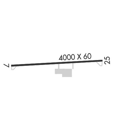
Runway Identifications
Runway Identification: 07/25
Length: 4000 ft
Width: 60 ft
Surface: ASPHALT-GOOD CONDITION
Edge lights: Medium Intensity

Treatment: NONE

 Runway: 07   Runway: 25
Mag heading: N/AMag heading: N/A
Rwy Slope: .06% UpRwy Slope: -.06% Down
Approach: Approach:
Pattern: Left TrafficPattern: Left Traffic
Markings: BASICMarkings: BASIC
Marking Condition: GOODMarking Condition: GOOD
Arresting Dev: Arresting Dev:
Lat & Long: N4806.3  W11943.7Lat. & Long.: N4806.3  W11942.7
Elev: 915.8 ft. MSLElev: 918.1 ft. MSL
TCH: TCH:
Visual Glide Path: Visual Glide Path:
Displaced Threshold: NoDisplaced Threshold: No
Touchdown Zone: YESTouchdown Zone: YES
Touchdown Elev.: 919.5 feetTouchdown Elev.: 919.5 feet
Visual Glide Slope: Visual Glide Slope:
RVR Equipment: RVR Equipment:
RVV Equipment: NORVV Equipment: NO
Approach Lights: Approach Lights:
REIL: NOREIL: NO
Centerline Lights: NOCenterline Lights: NO
Touchdown lights: NOTouchdown lights: NO
Runway Category: Runway with a Visual ApproachRunway Category: Runway with a Visual Approach
Declared Distances: Declared Distances:
Obstructions: TREESObstructions:
Marked: NOT Marked/LightedMarked:
Clearance slope: 20:1Clearance slope: 50:1
Obstruction height: 12 feet AGLObstruction height:
Dist. from runway: 447 feetDist. from runway:
Centerline offset: Centerline offset:
Comments: Comments:
C:1/P: