
| ||||||||||||||||||||||||||||||||||||||||||||
| ||||||||||||||||||||||||||||||||||||||||||||
| Rwy | Rwy | |||||||
| 4000x60 | 4000' | 4000x60 | 4000' | |||||
| Runway ID | Single Wheel | Double Wheel | Double Tandem Wheel | Dual Double Wheel |
| 12/30 | 12,500 | N/A | N/A | N/A |
| These numbers are Advisory and are not limits. The Airport Manager should have more accurate Weight Limits | ||||
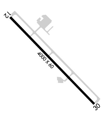 Airport Diagram might not be current. | |
| Facility Name: | WEISER MUNI |
| City Name: | WEISER |
| County: | WASHINGTON |
| State abbrev: | ID |
| State Name: | IDAHO |
| Ownership: | PUBLICLY OWNED |
| Use: | OPEN TO THE PUBLIC |
| Owner's Name: | CITY OF WEISER |
| Address: | 55 WEST IDAHO ST |
| WEISER, ID 83672 | |
| Owner's Phone: | 208-414-1965 |
| Manager's Name: | JIM METZGER |
| Address: | P O BOX 426 |
| WEISER, ID 83672 | |
| Phone: | (360)-903-6901 |
| FAA Region: | NORTHWEST MOUNTAIN |
| FAA Field Office: | HLN |
| Date | Sunrise | Sunset |
|---|---|---|
| 04/19/24 Friday | 6:56 | 20:38 |
| 04/20/24 Saturday | 6:55 | 20:39 |
| 04/21/24 Sunday | 6:53 | 20:41 |
| 04/22/24 Monday | 6:51 | 20:42 |
| 04/23/24 Tuesday | 6:50 | 20:43 |
| 04/24/24 Wednesday | 6:48 | 20:44 |
| 04/25/24 Thursday | 6:47 | 20:45 |
| 04/26/24 Friday | 6:45 | 20:47 |
| 04/27/24 Saturday | 6:44 | 20:48 |
| 04/28/24 Sunday | 6:42 | 20:49 |
| 04/29/24 Monday | 6:41 | 20:50 |
| 04/30/24 Tuesday | 6:39 | 20:51 |
| 05/01/24 Wednesday | 6:38 | 20:53 |
| 05/02/24 Thursday | 6:36 | 20:54 |
| Airport Attendance Schedule | MON-SAT 0900 - 1700 |
| Airport Status | OPERATIONAL (This Status can change at any time - please check NOTAMS) |
| Airport Lighting Schedule | ACTVT MIRL RWY 12/30; REIL RWY 12 & 30 - 3 CLICKS ONLY ON CTAF. PAPI RWY 30 UNUSBL DURG GROWING SEASON MAY TO SEPTEMBER EACH YR, DUE TO VEGETATION/CROPS BLOCKING VIS OF LGTS. |
| Airport Storage Available | Tie Downs, Hanger |
| Extra Services Available | Crop Dusting, Flight Instruction |
| Wind Indicator | YES - (lighted) |
| Control Tower | NO |
| CTAF Frequency | 122.800 |
| Unicom Frequency | 122.800 |
| Rotating Beacon Color | WG |
| Segmented Circle | YES |
| Landing Fee | NO |
| Airport Inspected | STATE - performed by STATE AERONAUTICAL PERSONNEL |
| Inspection Date | 02/27/2023 |
| Type of Fuel Available | Grade 100LL |
| Airframe Repair Service | MINOR |
| Power Plant Repair Service | MINOR |
| Latitude | N4412.3 |
| Longitude | W11657.6 (ESTIMATED) |
| Arpt Elevation | 2120ft (SURVEYED) |
| Magnetic Variation | 15E |
| 3 miles S | of WEISER |
| Traffic Pattern Altitude | |
| Sectional Chart | SALT LAKE CITY |
| Operations (Reported) | Yearly | Avg. Daily |
|---|---|---|
| General Aviation Transient | 1400 | 4 |
| General Aviation Local | 3500 | 10 |
| Air Taxi | 0 | 0 |
| Commerical | 0 | 0 |
| Commuter | 0 | 0 |
| Military | 250 | 1 |
| Aircraft based on Field | |
|---|---|
| General Aviation Singles | 22 |
| General Aviation Multi | 1 |
| Jet Aircraft | 0 |
| General Aviation Helicopters | 1 |
| Military Aircraft | 0 |
| Gliders | 0 |
| Ultralights | 0 |
| FSS on field | NO |
| FSS tie-in | BOISE |
| FSS Phone | 1-800-WX-BRIEF |
| Who issues Notams | BOI |
| Notam D service at airport | YES |
| ARTCC Name | SALT LAKE CITY |
| Airport Certification | |
| Aircraft Rescue & Firefighting Index | None |
| Airport of Entry | No |
| Custom Landing Rights | No |
| Joint Civil/Military | No |
| Military Landing rights | YES |
| NATIONAL PLAN OF INTEGRATED AIRPORT SYSTEMS (NPIAS) |
| GRANT AGREEMENTS UNDER FAAP/ADAP/AIP |
| ASSURANCES PURSUANT TO TITLE VI, CIVIL RIGHTS ACT OF 1964 |
| EXTSV AGRICULTURAL OPNS MAR-OCT. |
| BIRDS ON & INVOF ARPT. |
| FOR CD CTC SALT LAKE ARTCC AT 801-320-2568. |
Airport Communications & Frequencies:
| |||||||||
| Runway: 12 | Runway: 30 | ||
| Mag heading: | 121° | Mag heading: | 301° |
| Rwy Slope: | .23% Up | Rwy Slope: | -.23% Down |
| Approach: | Approach: | ||
| Pattern: | Left Traffic | Pattern: | Left Traffic |
| Markings: | NONPRECISION INSTRUMENT | Markings: | NONPRECISION INSTRUMENT |
| Marking Condition: | GOOD | Marking Condition: | GOOD |
| Arresting Dev: | Arresting Dev: | ||
| Lat & Long: | N4412.5 W11658.0 | Lat. & Long.: | N4412.0 W11657.3 |
| Elev: | 2111.3 ft. MSL | Elev: | 2120.3 ft. MSL |
| TCH: | TCH: | 38 ft. AGL | |
| Visual Glide Path: | Visual Glide Path: | 3.00 degrees | |
| Displaced Threshold: | No | Displaced Threshold: | No |
| Touchdown Zone: | YES | Touchdown Zone: | YES |
| Touchdown Elev.: | 2116.8 feet | Touchdown Elev.: | 2120.3 feet |
| Visual Glide Slope: | Visual Glide Slope: | 4-Light PAPI on LEFT side of Runway | |
| RVR Equipment: | RVR Equipment: | ||
| RVV Equipment: | NO | RVV Equipment: | NO |
| Approach Lights: | Approach Lights: | ||
| REIL: | YES | REIL: | YES |
| Centerline Lights: | NO | Centerline Lights: | NO |
| Touchdown lights: | NO | Touchdown lights: | NO |
| Runway Category: | Runway with a Visual Approach | Runway Category: | Runway with a Non-precision Approach |
| Declared Distances: | Declared Distances: | ||
| Obstructions: | TREES | Obstructions: | FENCE |
| Marked: | NOT Marked/Lighted; FENCE LIGHTED WITH RED OBSTRUCTION LIGHT | Marked: | NOT Marked/Lighted |
| Clearance slope: | 13:1 | Clearance slope: | |
| Obstruction height: | 45 feet AGL | Obstruction height: | 8 feet AGL |
| Dist. from runway: | 800 feet | Dist. from runway: | 200 feet |
| Centerline offset: | Centerline offset: | 190 feet left of centerline | |
| Comments: | Comments: |
