Click here for more info on on SMS!

KS84

COTTONWOOD MUNI
COTTONWOOD
ID
Time Zone: Pacific
Lat: N 4602.3
Long: W 11619.9
Elev: 3474
Var: -18
Longest Runway: 3100
CTAF: 122.9

FBO & Flight Services info for KS84

FBOs: Update your Fuel Prices

AIRPORTPh: 541-426-3562
-
Freq: 122.9
Service
Jet
100LL
SAF
MoGas
Fuel Avail: NO FUEL AVAILABLE
Full        Last Update: 04/26/2024 00:15:41

Self        
If you are an FBO, call 1-203-262-1700 to update your info or email: FltPlan.Advertising@garmin.com
Advertise your FBO on FltPlan.com

Runway & Approach Info for KS84
Rwy
Length
Land Dist**
Approach*
  Rwy
Length
Land Dist**
Approach*
07
3100x50  3100'          
 
  
25
  3100x50  3100'          
 
 * only ILS, LOC, LDA, and SDF approaches to a specific runway are shown
** For any Declared Landing Distance Available, please see A/FD or Approach plates
Runway Weight Capability (lbs.) Help
Runway IDSingle WheelDouble WheelDouble Tandem WheelDual Double Wheel
07/25N/AN/AN/AN/A
These numbers are Advisory and are not limits.   The Airport Manager should have more accurate Weight Limits
Approach Charts
FltPlan does not have IFR approach charts available for KS84.
Current Weather/Notams
Customs Information Send updates to Support@FltPlan.com
Customs Not Available
Database effective 05/16/2024
Airport Diagram of KS84
Airport Diagram might not be current.

Facility Name: COTTONWOOD MUNI
City Name: COTTONWOOD
County: IDAHO
State abbrev: ID
State Name: IDAHO
   
Ownership: PUBLICLY OWNED
Use: OPEN TO THE PUBLIC
Owner's Name: CITY OF COTTONWOOD
Address: P O BOX 571
 COTTONWOOD, ID 83522
Owner's Phone: 208-962-3231
  
Manager's Name: CLINT RIENER
Address: P O BOX 202
 COTTONWOOD, ID 83522
Phone: (208) 507-0461
   
FAA Region: NORTHWEST MOUNTAIN
FAA Field Office: HLN


Sunrise / Sunset times for COTTONWOOD MUNI

DateSunriseSunset
04/25/24 Thursday5:4019:47
04/26/24 Friday5:3919:48
04/27/24 Saturday5:3719:49
04/28/24 Sunday5:3519:51
04/29/24 Monday5:3419:52
04/30/24 Tuesday5:3219:53
05/01/24 Wednesday5:3119:55
05/02/24 Thursday5:2919:56
05/03/24 Friday5:2819:57
05/04/24 Saturday5:2619:58
05/05/24 Sunday5:2520:00
05/06/24 Monday5:2420:01
05/07/24 Tuesday5:2220:02
05/08/24 Wednesday5:2120:03

Airport Facilities

Airport Attendance ScheduleIRREGULAR
Airport Status OPERATIONAL (This Status can change at any time - please check NOTAMS)
Airport Lighting ScheduleACTVT MIRL RY 07/25, PVASI RY 25 AND WINDSOCK LGTS - CTAF.; ACTVT ROTG BCN - CTAF.
Airport Storage AvailableTie Downs
Extra Services AvailableCrop Dusting
Wind IndicatorYES - (lighted)
Control TowerNO
CTAF Frequency122.900
Unicom Frequency
Rotating Beacon ColorWG
Segmented CircleNO
Landing FeeNO

Airport Inspection Data

Airport InspectedSTATE - performed by STATE AERONAUTICAL PERSONNEL
Inspection Date07/24/2023

Airport Services

Type of Fuel AvailableNone
Airframe Repair ServiceNONE
Power Plant Repair ServiceNONE

Geographic Data

LatitudeN4602.3
LongitudeW11619.9 (ESTIMATED)
Arpt Elevation3474ft (ESTIMATED)
Magnetic Variation18E
1 miles SEof COTTONWOOD
Traffic Pattern Altitude
Sectional ChartGREAT FALLS

Aircraft Data

Operations (Reported)YearlyAvg. Daily
General Aviation Transient 30008
General Aviation Local 10003
Air Taxi 00
Commerical 00
Commuter 00
Military 00
Aircraft based on Field
General Aviation Singles 7
General Aviation Multi 0
Jet Aircraft 0
General Aviation Helicopters 0
Military Aircraft 0
Gliders 0
Ultralights 0

FAA Services

FSS on field NO
FSS tie-in BOISE
FSS Phone 1-800-WX-BRIEF
Who issues Notams BOI
Notam D service at airport YES
ARTCC Name SEATTLE

Federal Status

Airport Certification
Aircraft Rescue & Firefighting IndexNone
Airport of EntryNo
Custom Landing RightsNo
Joint Civil/MilitaryNo
Military Landing rightsNo

Remarks

FOR CD CTC SEATTLE ARTCC AT 253-351-3694.
Airport Communications & Frequencies:
CTAF Frequency:
122.900
Remarks
  • COMMUNICATIONS PRVDD BY BOISE RADIO ON FREQ 122.2 (COTTONWOOD RCO).
  • Runway Identifications
    Runway Identification: 07/25
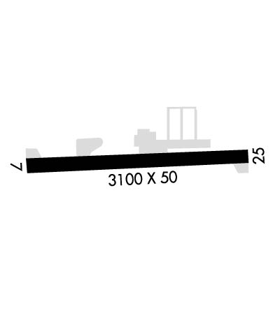
    Length: 3100 ft
    Width: 50 ft
    Surface: ASPHALT
    Edge lights: Medium Intensity

    Treatment: NONE

     Runway: 07   Runway: 25
    Mag heading: N/AMag heading: N/A
    Approach: Approach:
    Pattern: Left TrafficPattern: Left Traffic
    Markings: BASICMarkings: BASIC
    Marking Condition: GOODMarking Condition: GOOD
    Arresting Dev: Arresting Dev:
    Lat & Long:   Lat. & Long.:   
    Elev: N/AElev: N/A
    TCH: TCH: 50 ft. AGL
    Visual Glide Path: Visual Glide Path: 5.00 degrees
    Displaced Threshold: NoDisplaced Threshold: No
    Touchdown Zone: NOTouchdown Zone: NO
    Touchdown Elev.: Touchdown Elev.:
    Visual Glide Slope: Visual Glide Slope: PULSATING/STEADY BURNING VASI ON RIGHT SIDE OF RUNWAY
    RVR Equipment: RVR Equipment:
    RVV Equipment: NORVV Equipment: NO
    Approach Lights: Approach Lights:
    REIL: NOREIL: NO
    Centerline Lights: NOCenterline Lights: NO
    Touchdown lights: NOTouchdown lights: NO
    Runway Category: Runway with a Visual ApproachRunway Category: Runway with a Visual Approach
    Declared Distances: Declared Distances:
    Obstructions: FENCEObstructions:
    Marked: NOT Marked/LightedMarked:
    Clearance slope: Clearance slope: 50:1
    Obstruction height: 5 feet AGLObstruction height:
    Dist. from runway: 200 feetDist. from runway:
    Centerline offset: Centerline offset:
    Comments: +4 FT FENCE 0 FT FM RY END 50 FT R; +4 FT FENCE 90 FT FM RY END ON CNTRLN' +6 FT POST AT 90 FT 50 FT R.Comments: RWY 25 +7 FT FENCE 112 FT FM RWY END ON CNTRLN; +15 FT ROAD 120 FT FM RWY END ON CNTRLN; +7 FT FENCE AT 0 FT 75 FT RIGHT; +15 FT ROAD 0 FT FM RWY END 85 FT RIGHT AND 110 FT LEFT.
    C:/P: