Click here for more info on on SMS!

KS78

EMMETT MUNI
EMMETT
ID
Time Zone: Mountain
Lat: N 4351.2
Long: W 11632.3
Elev: 2354
Var: -17
Longest Runway: 3307
CTAF: 122.9

FBO & Flight Services info for KS78

FBOs: Update your Fuel Prices
Providing high quality fuel and services to you and your customers, from Phillips 66 Aviation.
Ph: 208-861-9056 Fax: 208-939-6632 Freq: 122.9WebsiteE-Mail
                          
Service
Jet
100LL
SAF
MoGas
Fuel Avail: 24/7
Full        Last Update: 04/24/2024 11:39

Self  6.90    
Misc. Info: Discount of 25 cents/gallon with $1000 purchase, call 208-861-9056 for info.Address: 1495 E SALESYARD RD   EMMETT, ID 83617

If you are an FBO, call 1-203-262-1700 to update your info or email: FltPlan.Advertising@garmin.com
Advertise your FBO on FltPlan.com

Runway & Approach Info for KS78
Rwy
Length
Land Dist**
Approach*
  Rwy
Length
Land Dist**
Approach*
10
3307x55  3307'          
 
  
28
  3307x55  3307'          
 
 * only ILS, LOC, LDA, and SDF approaches to a specific runway are shown
** For any Declared Landing Distance Available, please see A/FD or Approach plates
Runway Weight Capability (lbs.) Help
Runway IDSingle WheelDouble WheelDouble Tandem WheelDual Double Wheel
10/288,000N/AN/AN/A
These numbers are Advisory and are not limits.   The Airport Manager should have more accurate Weight Limits
Approach Charts
FltPlan does not have IFR approach charts available for KS78.
Current Weather/Notams
Customs Information Send updates to Support@FltPlan.com
Customs Not Available
Database effective 05/16/2024
Airport Diagram of KS78
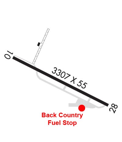
Airport Diagram might not be current.

Facility Name: EMMETT MUNI
City Name: EMMETT
County: GEM
State abbrev: ID
State Name: IDAHO
   
Ownership: PUBLICLY OWNED
Use: OPEN TO THE PUBLIC
Owner's Name: CITY OF EMMETT
Address: 501 EAST MAIN STREET
 EMMETT, ID 83617
Owner's Phone: 208 365-9569
  
Manager's Name: CLINT SEAMONS
Address: 601 E 3RD ST
 EMMETT, ID 83617
Phone: 208 365-9569
   
FAA Region: NORTHWEST MOUNTAIN
FAA Field Office: HLN


Sunrise / Sunset times for EMMETT MUNI

DateSunriseSunset
04/25/24 Thursday6:4620:43
04/26/24 Friday6:4420:44
04/27/24 Saturday6:4320:45
04/28/24 Sunday6:4120:47
04/29/24 Monday6:4020:48
04/30/24 Tuesday6:3820:49
05/01/24 Wednesday6:3720:50
05/02/24 Thursday6:3520:51
05/03/24 Friday6:3420:52
05/04/24 Saturday6:3320:54
05/05/24 Sunday6:3120:55
05/06/24 Monday6:3020:56
05/07/24 Tuesday6:2920:57
05/08/24 Wednesday6:2820:58

Airport Facilities

Airport Attendance ScheduleUNATTENDED
Airport Status OPERATIONAL (This Status can change at any time - please check NOTAMS)
Airport Lighting ScheduleACTVT MIRL RY 10/28-CTAF.
Airport Storage AvailableTie Downs
Extra Services AvailableNONE
Wind IndicatorYES - (lighted)
Control TowerNO
CTAF Frequency122.900
Unicom Frequency
Rotating Beacon ColorWG
Segmented CircleYES
Landing FeeNO

Airport Inspection Data

Airport InspectedSTATE - performed by STATE AERONAUTICAL PERSONNEL
Inspection Date02/21/2024

Airport Services

Type of Fuel AvailableGrade 100LL; -10FUEL AVBL 24 HRS SELF SER W/CREDIT CARD.
Airframe Repair ServiceNONE
Power Plant Repair ServiceNONE

Geographic Data

LatitudeN4351.2
LongitudeW11632.3 (ESTIMATED)
Arpt Elevation2354ft (ESTIMATED)
Magnetic Variation17E
3 miles SWof EMMETT
Traffic Pattern Altitude
Sectional ChartSALT LAKE CITY

Aircraft Data

Operations (Reported)YearlyAvg. Daily
General Aviation Transient 600016
General Aviation Local 570016
Air Taxi 3001
Commerical 00
Commuter 00
Military 00
Aircraft based on Field
General Aviation Singles 21
General Aviation Multi 0
Jet Aircraft 0
General Aviation Helicopters 0
Military Aircraft 0
Gliders 0
Ultralights 0

FAA Services

FSS on field NO
FSS tie-in BOISE
FSS Phone 1-800-WX-BRIEF
Who issues Notams BOI
Notam D service at airport YES
ARTCC Name SALT LAKE CITY

Federal Status

Airport Certification
Aircraft Rescue & Firefighting IndexNone
Airport of EntryNo
Custom Landing RightsNo
Joint Civil/MilitaryNo
Military Landing rightsYES

Federal Agreements

GRANT AGREEMENTS UNDER FAAP/ADAP/AIP
ASSURANCES PURSUANT TO TITLE VI, CIVIL RIGHTS ACT OF 1964

Remarks

GOLF COURSE ON BOTH SIDES OF RWY.
1800' X 20' PVT GRVL AGG RWY LCTD ADJCNT NW OF ARPT.
GOLF COURSE ROAD CROSSES NEAR RWY 28 THLD. WATCH FOR GOLFERS ON RWY.
FOR CD CTC BIG SKY APCH AT 208-364-5860/5861.
Runway Identifications
Runway Identification: 10/28
Length: 3307 ft
Width: 55 ft
Surface: ASPHALT-GOOD CONDITION
Edge lights: Medium Intensity

Treatment: NONE

 Runway: 10   Runway: 28
Mag heading: 99°Mag heading: 279°
Rwy Slope: .09% UpRwy Slope: -.09% Down
Approach: Approach:
Pattern: Left TrafficPattern: Left Traffic
Markings: NONSTANDARDMarkings: BASIC
Marking Condition: GOOD; RWY 10 190FT NON-STD. DTHR MKD W/YELLOW CHEVRONS.Marking Condition: GOOD
Arresting Dev: Arresting Dev:
Lat & Long: N4351.3  W11632.7Lat. & Long.: N4351.0  W11632.0
Elev: 2351.0 ft. MSLElev: 2354.0 ft. MSL
TCH: TCH:
Visual Glide Path: Visual Glide Path:
Displaced Threshold: NoDisplaced Threshold: RWY 28 360 FT DTHR MKD WITH W THLD BAR AND W ARROWS.
Touchdown Zone: NOTouchdown Zone: NO
Touchdown Elev.: Touchdown Elev.:
Visual Glide Slope: Visual Glide Slope:
RVR Equipment: RVR Equipment:
RVV Equipment: NORVV Equipment: NO
Approach Lights: Approach Lights:
REIL: NOREIL: NO
Centerline Lights: NOCenterline Lights: NO
Touchdown lights: NOTouchdown lights: NO
Runway Category: Runway with a Visual ApproachRunway Category: Runway with a Visual Approach
Declared Distances: TORA:2934' TODA:2934'Declared Distances: TORA:3107' TODA:3107'
Obstructions: TREEObstructions: ROAD
Marked: NOT Marked/LightedMarked: NOT Marked/Lighted
Clearance slope: APCH SLP 0:1 AT END OF DTHR; 25 FT TREE @207 FT, 30R.Clearance slope: +14 FT ROAD @15 FT, ON CNTR LINE, 0:1 SLP AT END OF DTHR.
Obstruction height: 25 feet AGLObstruction height: 14 feet AGL
Dist. from runway: 207 feetDist. from runway: 200 feet
Centerline offset: 75 right of centerlineCenterline offset:
Comments: Comments: 10 FT PVT ROAD AT 0 FT, 85 FT L; +5 FT FENCE AT 190 FT ON CNTRLN.
C:/P: