Approach Charts
| FltPlan does not have IFR approach charts available for KS64. |
Current Weather/Notams (Metars, TAFs, Notams, NWS Forecast, PIREPS, and nearby weather)
Customs Information Send updates to Support@FltPlan.com
Customs Not Available
Database effective 05/16/2024
Airport Diagram might not be current.
|
| Facility Name: | STANFORD/BIGGERSTAFF FLD |
| City Name: | STANFORD |
| County: | JUDITH BASIN |
| State abbrev: | MT |
| State Name: | MONTANA |
| | |
| Ownership: | PUBLICLY OWNED |
| Use: | OPEN TO THE PUBLIC |
| Owner's Name: | JUDITH BASIN COUNTY |
| Address: | COUNTY COURTHOUSE PO 427 |
| | STANFORD, MT 59479 |
| Owner's Phone: | 406-566-2277 |
| | |
| Manager's Name: | TYLER YOUDERIAN; TYLER@YOUDERIANCONST.COM |
| Address: | PO BOX 400 |
| | STANFORD, MT 59479 |
| Phone: | (406) 490-7708 |
| | |
| FAA Region: | NORTHWEST MOUNTAIN |
| FAA Field Office: | HLN |
Runway Identifications
Runway Identification: 07/25Length: 1600 ft
Width: 100 ft
Surface: GRASS-POOR CONDITION
Edge lights: Treatment: NONE
| | Runway: 07 | | Runway: 25 |
| Mag heading: | N/A | Mag heading: | N/A |
| Rwy Slope: | -.68% Down | Rwy Slope: | .68% Up |
| Approach: | | Approach: | |
| Pattern: | Left Traffic | Pattern: | Left Traffic |
| Markings: | | Markings: | |
| Marking Condition: | | Marking Condition: | |
| Arresting Dev: | | Arresting Dev: | |
| Lat & Long: | N4708.7 W11013.9 | Lat. & Long.: | N4708.7 W11013.5 |
| Elev: | 4327.6 ft. MSL | Elev: | 4316.7 ft. MSL |
| TCH: | | TCH: | |
| Visual Glide Path: | | Visual Glide Path: | |
| Displaced Threshold: | No | Displaced Threshold: | No |
| Touchdown Zone: | YES | Touchdown Zone: | YES |
| Touchdown Elev.: | 4327.6 feet | Touchdown Elev.: | 4327.6 feet |
| Visual Glide Slope: | | Visual Glide Slope: | |
| RVR Equipment: | | RVR Equipment: | |
| RVV Equipment: | NO | RVV Equipment: | NO |
| Approach Lights: | | Approach Lights: | |
| REIL: | NO | REIL: | NO |
| Centerline Lights: | NO | Centerline Lights: | NO |
| Touchdown lights: | NO | Touchdown lights: | NO |
| Runway Category: | Runway with a Visual Approach | Runway Category: | Runway with a Visual Approach |
| Declared Distances: | | Declared Distances: | |
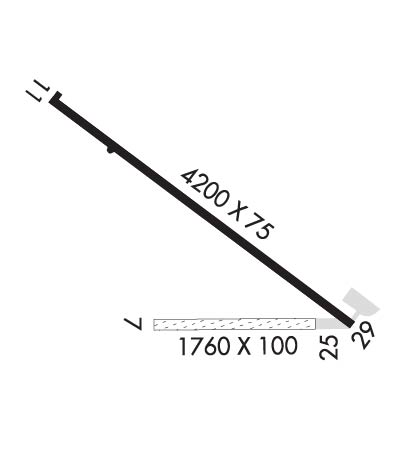
Runway Identification: 12/30Length: 4200 ft
Width: 75 ft
Surface: ASPHALT
Edge lights: Medium IntensityTreatment: NONE
| | Runway: 12 | | Runway: 30 |
| Mag heading: | N/A | Mag heading: | N/A |
| Rwy Slope: | -.27% Down | Rwy Slope: | .27% Up |
| Approach: | | Approach: | |
| Pattern: | Left Traffic | Pattern: | Left Traffic |
| Markings: | NONPRECISION INSTRUMENT | Markings: | NONPRECISION INSTRUMENT |
| Marking Condition: | FAIR | Marking Condition: | FAIR |
| Arresting Dev: | | Arresting Dev: | |
| Lat & Long: | N4709.1 W11014.2 | Lat. & Long.: | N4708.7 W11013.4 |
| Elev: | 4324.5 ft. MSL | Elev: | 4313.2 ft. MSL |
| TCH: | | TCH: | 35 ft. AGL |
| Visual Glide Path: | | Visual Glide Path: | 3.00 degrees |
| Displaced Threshold: | No | Displaced Threshold: | No |
| Touchdown Zone: | YES | Touchdown Zone: | YES |
| Touchdown Elev.: | 4324.5 feet | Touchdown Elev.: | 4321.4 feet |
| Visual Glide Slope: | | Visual Glide Slope: | 2-Light PAPI on LEFT side of Runway |
| RVR Equipment: | | RVR Equipment: | |
| RVV Equipment: | NO | RVV Equipment: | NO |
| Approach Lights: | | Approach Lights: | |
| REIL: | NO | REIL: | NO |
| Centerline Lights: | NO | Centerline Lights: | NO |
| Touchdown lights: | NO | Touchdown lights: | NO |
| Runway Category: | Runway with a Visual Approach | Runway Category: | Runway with a Visual Approach |
| Declared Distances: | | Declared Distances: | |

