Click here for more info on on SMS!

KS36

CREST AIRPARK
KENT
WA
Time Zone: Pacific
Lat: N 4720.2
Long: W 12206.2
Elev: 472
Var: -20
Longest Runway: 3288
CTAF: 123.0

FBO & Flight Services info for KS36

FBOs: Update your Fuel Prices
Providing high quality fuel and services to you and your customers from Phillips 66 Aviation.
Ph: 253-631-7100
-
Freq: 123.0WebsiteE-Mail
Service
Jet
100LL
SAF
MoGas
Fuel Avail: 24 hours
Full        Last Update: 03/27/2024 12:20

Self  6.35    
Misc. Info: Address: 29300 179TH PLACE SE   KENT, WA 98042

If you are an FBO, call 1-203-262-1700 to update your info or email: FltPlan.Advertising@garmin.com
Advertise your FBO on FltPlan.com

Runway & Approach Info for KS36
Rwy
Length
Land Dist**
Approach*
  Rwy
Length
Land Dist**
Approach*
15
3288x40  3288'          
 
  
33
  3288x40  3007'          
 
 * only ILS, LOC, LDA, and SDF approaches to a specific runway are shown
** For any Declared Landing Distance Available, please see A/FD or Approach plates
Runway Weight Capability (lbs.) Help
Runway IDSingle WheelDouble WheelDouble Tandem WheelDual Double Wheel
15/3312,000N/AN/AN/A
These numbers are Advisory and are not limits.   The Airport Manager should have more accurate Weight Limits
Approach Charts
FltPlan does not have IFR approach charts available for KS36.
Current Weather/Notams
Customs Information Send updates to Support@FltPlan.com
Customs Not Available
Database effective 04/18/2024
Airport Diagram of KS36
Airport Diagram might not be current.

Facility Name: NORMAN GRIER FLD
City Name: KENT
County: KING
State abbrev: WA
State Name: WASHINGTON
   
Ownership: PRIVATELY OWNED
Use: OPEN TO THE PUBLIC
Owner's Name: GRIER FAMILY HOLDINGS, LLC
Address: 29300 179 PLACE SE
 KENT, WA 98042
Owner's Phone: 253-631-7100
  
Manager's Name: RIKKI BIRGE
Address: 29300 179TH PLACE SE
 KENT, WA 98042
Phone: 253-631-7100
   
FAA Region: NORTHWEST MOUNTAIN
FAA Field Office: SEA


Sunrise / Sunset times for NORMAN GRIER FLD

DateSunriseSunset
04/17/24 Wednesday6:1520:02
04/18/24 Thursday6:1320:03
04/19/24 Friday6:1120:04
04/20/24 Saturday6:0920:06
04/21/24 Sunday6:0720:07
04/22/24 Monday6:0620:09
04/23/24 Tuesday6:0420:10
04/24/24 Wednesday6:0220:11
04/25/24 Thursday6:0020:13
04/26/24 Friday5:5920:14
04/27/24 Saturday5:5720:16
04/28/24 Sunday5:5520:17
04/29/24 Monday5:5420:18
04/30/24 Tuesday5:5220:20

Airport Facilities

Airport Attendance Schedule7 Days A Week 0900-1700
Airport Status OPERATIONAL (This Status can change at any time - please check NOTAMS)
Airport Lighting Schedule
Airport Storage AvailableTie Downs
Extra Services AvailableFlight Instruction, Aircraft Rental
Wind IndicatorYES - (lighted)
Control TowerNO
CTAF Frequency123.000
Unicom Frequency123.000
Rotating Beacon ColorWG
Segmented CircleNO
Landing FeeNO

Airport Inspection Data

Airport InspectedCONTRACTOR - performed by STATE AERONAUTICAL PERSONNEL
Inspection Date07/13/2023

Airport Services

Type of Fuel AvailableGrade 100LL; -1024 HR CREDIT CARD FUEL AVBL.
Airframe Repair ServiceMAJOR
Power Plant Repair ServiceMAJOR

Geographic Data

LatitudeN4720.2
LongitudeW12206.2 (ESTIMATED)
Arpt Elevation472ft (ESTIMATED)
Magnetic Variation20E
5 miles SEof KENT
Traffic Pattern Altitude
Sectional ChartSEATTLE

Aircraft Data

Operations (Reported)YearlyAvg. Daily
General Aviation Transient 101200277
General Aviation Local 1265035
Air Taxi 00
Commerical 00
Commuter 00
Military 00
Aircraft based on Field
General Aviation Singles 327
General Aviation Multi 5
Jet Aircraft 0
General Aviation Helicopters 0
Military Aircraft 0
Gliders 0
Ultralights 0

FAA Services

FSS on field NO
FSS tie-in SEATTLE
FSS Phone 1-800-WX-BRIEF
Who issues Notams SEA
Notam D service at airport YES
ARTCC Name SEATTLE

Federal Status

Airport Certification
Aircraft Rescue & Firefighting IndexNone
Airport of EntryNo
Custom Landing RightsNo
Joint Civil/MilitaryNo
Military Landing rightsYES

Remarks

TREES BOTH SIDES OF RWY IN TRSN SFC.
TREES ON BOTH SIDES OF RWY 15/33.
NIGHT OPS USE RWY 15, WIND AND WX PMTG.
ARPT CLSD WHEN SNOW ON RWY.
FOR CD CTC SEATTLE APCH AT 206-214-4723.
TGLS PROHIBITED.
RWY 15 1 15/33 NSTD MARKINGS NRS & CNTRLN ONLY; FADED.
Runway Identifications
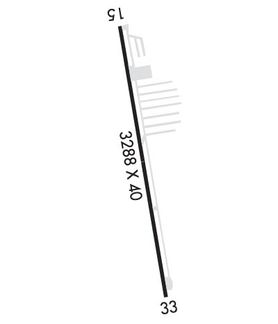
Runway Identification: 15/33
Length: 3288 ft
Width: 40 ft
Surface: ASPHALT-GOOD CONDITION
Edge lights: Low Intensity

Treatment: NONE

 Runway: 15   Runway: 33
Mag heading: N/AMag heading: N/A
Approach: Approach:
Pattern: Left TrafficPattern: Left Traffic
Markings: NONSTANDARDMarkings: NONSTANDARD
Marking Condition: POOR; MARKINGS FADED.Marking Condition: POOR; MARKINGS FADED.
Arresting Dev: Arresting Dev:
Lat & Long: N4720.5  W12206.3Lat. & Long.: N4720.0  W12206.1
Elev: N/AElev: N/A
TCH: TCH:
Visual Glide Path: Visual Glide Path:
Displaced Threshold: NoDisplaced Threshold: 281 feet
Touchdown Zone: NOTouchdown Zone: NO
Touchdown Elev.: Touchdown Elev.:
Visual Glide Slope: Visual Glide Slope:
RVR Equipment: RVR Equipment:
RVV Equipment: NORVV Equipment: NO
Approach Lights: Approach Lights:
REIL: NOREIL: NO
Centerline Lights: NOCenterline Lights: NO
Touchdown lights: NOTouchdown lights: NO
Runway Category: Runway with a Visual ApproachRunway Category: Runway with a Visual Approach
Declared Distances: Declared Distances:
Obstructions: TREESObstructions: TREES
Marked: NOT Marked/LightedMarked: NOT Marked/Lighted
Clearance slope: 9:1Clearance slope: 12:1; RWY 33 APPROACH RATIO 6:1 FROM DSPLCD THR.
Obstruction height: 76 feet AGLObstruction height: 107 feet AGL
Dist. from runway: 901 feetDist. from runway: 1560 feet
Centerline offset: Centerline offset:
Comments: TREES IN PRIM SFC, PARKED ACFT IN PRIM SFC BOTH SIDES OF RWY AND 3 FT SIGN, 92 FT LEFT, 27 FT FROM THR.Comments: +95 FT TREES IN PRI SFC 0-200 FT FM THR, 120 FT RIGHT.
C:/P: