Approach Charts
| FltPlan does not have IFR approach charts available for KS35. |
Current Weather/Notams (Metars, TAFs, Notams, NWS Forecast, PIREPS, and nearby weather)
Customs Information Send updates to Support@FltPlan.com
Customs Not Available
Database effective 04/18/2024
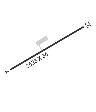
Airport Diagram might not be current.
|
| Facility Name: | OKANOGAN LEGION |
| City Name: | OKANOGAN |
| County: | OKANOGAN |
| State abbrev: | WA |
| State Name: | WASHINGTON |
| | |
| Ownership: | PUBLICLY OWNED |
| Use: | OPEN TO THE PUBLIC |
| Owner's Name: | CITY OF OKANOGAN |
| Address: | PO BOX 752 |
| | OKANOGAN, WA 98840 |
| Owner's Phone: | 509-422-3600 |
| | |
| Manager's Name: | AMBER SCOTT |
| Address: | PO BOX 752 |
| | OKANOGAN, WA 98840 |
| Phone: | (509) 422-3600 |
| | |
| FAA Region: | NORTHWEST MOUNTAIN |
| FAA Field Office: | SEA |
Runway Identifications
Runway Identification: 04/22Length: 2533 ft
Width: 36 ft
Surface: ASPHALT
Edge lights: Medium IntensityTreatment: NONE
| | Runway: 04 | | Runway: 22 |
| Mag heading: | N/A | Mag heading: | N/A |
| Rwy Slope: | -.32% Down | Rwy Slope: | .32% Up |
| Approach: | | Approach: | |
| Pattern: | Left Traffic | Pattern: | Right Traffic |
| Markings: | BASIC | Markings: | BASIC |
| Marking Condition: | GOOD | Marking Condition: | GOOD |
| Arresting Dev: | | Arresting Dev: | |
| Lat & Long: | N4821.6 W11934.3 | Lat. & Long.: | N4821.8 W11933.8 |
| Elev: | 1042.0 ft. MSL | Elev: | 1034.0 ft. MSL |
| TCH: | | TCH: | |
| Visual Glide Path: | | Visual Glide Path: | |
| Displaced Threshold: | No | Displaced Threshold: | No |
| Touchdown Zone: | NO | Touchdown Zone: | NO |
| Touchdown Elev.: | | Touchdown Elev.: | |
| Visual Glide Slope: | | Visual Glide Slope: | |
| RVR Equipment: | | RVR Equipment: | |
| RVV Equipment: | NO | RVV Equipment: | NO |
| Approach Lights: | | Approach Lights: | |
| REIL: | NO | REIL: | NO |
| Centerline Lights: | NO | Centerline Lights: | NO |
| Touchdown lights: | NO | Touchdown lights: | NO |
| Runway Category: | Runway with a Visual Approach | Runway Category: | Runway with a Visual Approach |
| Declared Distances: | | Declared Distances: | |
| Obstructions: | | Obstructions: | HILL |
| Marked: | | Marked: | NOT Marked/Lighted |
| Clearance slope: | 50:1 | Clearance slope: | |
| Obstruction height: | | Obstruction height: | 5 feet AGL |
| Dist. from runway: | | Dist. from runway: | 200 feet |
| Centerline offset: | | Centerline offset: | |
| Comments: | RWY 04 4 FT BRUSH AND 5 FT FENCE 90 FT FM THR, ROAD 125 FT FM THR. | Comments: | |

