
| ||||||||||||||||||||||||||||||||
| ||||||||||||||||||||||||||||||||
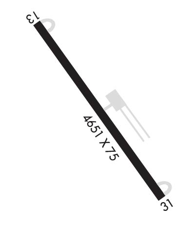
| Rwy | Rwy | |||||||
| 4650x75 | 4650' | 4650x75 | 4650' | |||||
| Runway ID | Single Wheel | Double Wheel | Double Tandem Wheel | Dual Double Wheel |
| 13/31 | 12,500 | 18,000 | N/A | N/A |
| These numbers are Advisory and are not limits. The Airport Manager should have more accurate Weight Limits | ||||
| FltPlan does not have IFR approach charts available for KS34. |
 Airport Diagram might not be current. | |
| Facility Name: | PLAINS |
| City Name: | PLAINS |
| County: | SANDERS |
| State abbrev: | MT |
| State Name: | MONTANA |
| Ownership: | PUBLICLY OWNED |
| Use: | OPEN TO THE PUBLIC |
| Owner's Name: | SANDERS COUNTY |
| Address: | PO BOX 519 |
| THOMPSON FALLS, MT 59873 | |
| Owner's Phone: | 406-826-3605 |
| Manager's Name: | RANDY GARRISON |
| Address: | PO BOX 988 |
| PLAINS, MT 59859 | |
| Phone: | 406-826-3605; CELL NUMBER 406-370-6179 |
| FAA Region: | NORTHWEST MOUNTAIN |
| FAA Field Office: | HLN |
| Date | Sunrise | Sunset |
|---|---|---|
| 04/22/24 Monday | 6:37 | 20:40 |
| 04/23/24 Tuesday | 6:35 | 20:41 |
| 04/24/24 Wednesday | 6:33 | 20:43 |
| 04/25/24 Thursday | 6:31 | 20:44 |
| 04/26/24 Friday | 6:30 | 20:46 |
| 04/27/24 Saturday | 6:28 | 20:47 |
| 04/28/24 Sunday | 6:26 | 20:48 |
| 04/29/24 Monday | 6:25 | 20:50 |
| 04/30/24 Tuesday | 6:23 | 20:51 |
| 05/01/24 Wednesday | 6:21 | 20:53 |
| 05/02/24 Thursday | 6:20 | 20:54 |
| 05/03/24 Friday | 6:18 | 20:55 |
| 05/04/24 Saturday | 6:17 | 20:57 |
| 05/05/24 Sunday | 6:15 | 20:58 |
| Airport Attendance Schedule | UNATTENDED |
| Airport Status | OPERATIONAL (This Status can change at any time - please check NOTAMS) |
| Airport Lighting Schedule | ACTVT PAPI RWY 31; MIRL RWY 13/31 - CTAF. |
| Airport Storage Available | Tie Downs |
| Extra Services Available | Flight Instruction |
| Wind Indicator | YES - (lighted) |
| Control Tower | NO |
| CTAF Frequency | 122.900 |
| Unicom Frequency | |
| Rotating Beacon Color | WG |
| Segmented Circle | YES |
| Landing Fee | NO |
| Airport Inspected | STATE - performed by STATE AERONAUTICAL PERSONNEL |
| Inspection Date | 03/18/2021 |
| Type of Fuel Available | None |
| Airframe Repair Service | NONE |
| Power Plant Repair Service | NONE |
| Latitude | N4728.4 |
| Longitude | W11454.4 (ESTIMATED) |
| Arpt Elevation | 2467ft (SURVEYED) |
| Magnetic Variation | 18E |
| 1 miles NW | of PLAINS |
| Traffic Pattern Altitude | |
| Sectional Chart | GREAT FALLS |
| Operations (Reported) | Yearly | Avg. Daily |
|---|---|---|
| General Aviation Transient | 500 | 1 |
| General Aviation Local | 2000 | 5 |
| Air Taxi | 40 | 0 |
| Commerical | 0 | 0 |
| Commuter | 0 | 0 |
| Military | 0 | 0 |
| Aircraft based on Field | |
|---|---|
| General Aviation Singles | 16 |
| General Aviation Multi | 0 |
| Jet Aircraft | 0 |
| General Aviation Helicopters | 0 |
| Military Aircraft | 0 |
| Gliders | 0 |
| Ultralights | 0 |
| FSS on field | NO |
| FSS tie-in | GREAT FALLS |
| FSS Phone | 1-800-WX-BRIEF |
| Who issues Notams | GTF |
| Notam D service at airport | YES |
| ARTCC Name | SALT LAKE CITY |
| Airport Certification | |
| Aircraft Rescue & Firefighting Index | None |
| Airport of Entry | No |
| Custom Landing Rights | No |
| Joint Civil/Military | No |
| Military Landing rights | YES |
| NATIONAL PLAN OF INTEGRATED AIRPORT SYSTEMS (NPIAS) |
| PHONE ON ARPT. |
| FOR CD CTC SALT LAKE ARTCC AT 801-320-2568. |
| Runway: 13 | Runway: 31 | ||
| Mag heading: | 124° | Mag heading: | 304° |
| Rwy Slope: | -1.00% Down | Rwy Slope: | 1.00% Up |
| Approach: | Approach: | ||
| Pattern: | Left Traffic | Pattern: | Left Traffic |
| Markings: | BASIC | Markings: | BASIC |
| Marking Condition: | GOOD | Marking Condition: | GOOD |
| Arresting Dev: | Arresting Dev: | ||
| Lat & Long: | N4728.7 W11454.8 | Lat. & Long.: | N4728.1 W11454.1 |
| Elev: | 2461.5 ft. MSL | Elev: | 2414.9 ft. MSL |
| TCH: | TCH: | 20 ft. AGL | |
| Visual Glide Path: | Visual Glide Path: | 3.00 degrees | |
| Displaced Threshold: | No | Displaced Threshold: | No |
| Touchdown Zone: | YES | Touchdown Zone: | YES |
| Touchdown Elev.: | 2465.4 feet | Touchdown Elev.: | 2467.0 feet |
| Visual Glide Slope: | Visual Glide Slope: | 2-Light PAPI on LEFT side of Runway | |
| RVR Equipment: | RVR Equipment: | ||
| RVV Equipment: | NO | RVV Equipment: | NO |
| Approach Lights: | Approach Lights: | ||
| REIL: | NO | REIL: | NO |
| Centerline Lights: | NO | Centerline Lights: | NO |
| Touchdown lights: | NO | Touchdown lights: | NO |
| Runway Category: | Runway with a Visual Approach | Runway Category: | Runway with a Visual Approach |
| Declared Distances: | Declared Distances: |
