Current Weather/Notams (Metars, TAFs, Notams, NWS Forecast, PIREPS, and nearby weather)
Customs Information Send updates to Support@FltPlan.com
Customs Not Available
Database effective 05/16/2024
Airport Diagram might not be current.
|
| Facility Name: | MADRAS MUNI |
| City Name: | MADRAS |
| County: | JEFFERSON |
| State abbrev: | OR |
| State Name: | OREGON |
| | |
| Ownership: | PUBLICLY OWNED |
| Use: | OPEN TO THE PUBLIC |
| Owner's Name: | CITY |
| Address: | 71 SE D ST, CITY HALL |
| | MADRAS, OR 97741 |
| Owner's Phone: | 541-475-2344 |
| | |
| Manager's Name: | LORRAINE MARTINELLI |
| Address: | 2028 NW BERG DR |
| | MADRAS, OR 97741 |
| Phone: | 541-777-4935 |
| | |
| FAA Region: | NORTHWEST MOUNTAIN |
| FAA Field Office: | SEA |
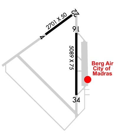
Runway Identifications
Runway Identification: 04/22Length: 2701 ft
Width: 50 ft
Surface: ASPHALT-FAIR CONDITION
Edge lights: Treatment: NONE
| | Runway: 04 | | Runway: 22 |
| Mag heading: | 39° | Mag heading: | 219° |
| Rwy Slope: | .29% Up | Rwy Slope: | -.29% Down |
| Approach: | | Approach: | |
| Pattern: | Left Traffic | Pattern: | Left Traffic |
| Markings: | BASIC | Markings: | BASIC |
| Marking Condition: | FAIR; RY 04/22 MKD WITH WHITE REFLECTORS. | Marking Condition: | FAIR |
| Arresting Dev: | | Arresting Dev: | |
| Lat & Long: | N4440.4 W12109.8 | Lat. & Long.: | N4440.7 W12109.3 |
| Elev: | 2417.0 ft. MSL | Elev: | 2424.7 ft. MSL |
| TCH: | | TCH: | |
| Visual Glide Path: | | Visual Glide Path: | |
| Displaced Threshold: | No | Displaced Threshold: | No |
| Touchdown Zone: | YES | Touchdown Zone: | YES |
| Touchdown Elev.: | 2424.7 feet | Touchdown Elev.: | 2424.7 feet |
| Visual Glide Slope: | | Visual Glide Slope: | |
| RVR Equipment: | | RVR Equipment: | |
| RVV Equipment: | NO | RVV Equipment: | NO |
| Approach Lights: | | Approach Lights: | |
| REIL: | NO | REIL: | NO |
| Centerline Lights: | NO | Centerline Lights: | NO |
| Touchdown lights: | NO | Touchdown lights: | NO |
| Runway Category: | Runway with a Visual Approach | Runway Category: | Runway with a Visual Approach |
| Declared Distances: | | Declared Distances: | |
| Obstructions: | | Obstructions: | ROAD |
| Marked: | | Marked: | NOT Marked/Lighted |
| Clearance slope: | 50:1 | Clearance slope: | |
| Obstruction height: | | Obstruction height: | 15 feet AGL |
| Dist. from runway: | | Dist. from runway: | 200 feet |
| Centerline offset: | | Centerline offset: | 240 feet right of centerline |
| Comments: | | Comments: | +5 FT FENCE 190 FT FM RY END 228 FT R. |
Runway Identification: 16/34Length: 5091 ft
Width: 75 ft
Surface: ASPHALT-GOOD CONDITION
Edge lights: Medium IntensityTreatment: NONE
| | Runway: 16 | | Runway: 34 |
| Mag heading: | 164° | Mag heading: | 344° |
| Rwy Slope: | .14% Up | Rwy Slope: | -.14% Down |
| Approach: | | Approach: | |
| Pattern: | Left Traffic | Pattern: | Left Traffic |
| Markings: | NONPRECISION INSTRUMENT | Markings: | NONPRECISION INSTRUMENT |
| Marking Condition: | GOOD | Marking Condition: | GOOD |
| Arresting Dev: | | Arresting Dev: | |
| Lat & Long: | N4440.4 W12109.2 | Lat. & Long.: | N4439.6 W12109.2 |
| Elev: | 2430.3 ft. MSL | Elev: | 2437.4 ft. MSL |
| TCH: | | TCH: | 50 ft. AGL |
| Visual Glide Path: | | Visual Glide Path: | 3.00 degrees |
| Displaced Threshold: | No | Displaced Threshold: | No |
| Touchdown Zone: | YES | Touchdown Zone: | YES |
| Touchdown Elev.: | 2433.9 feet | Touchdown Elev.: | 2437.6 feet |
| Visual Glide Slope: | | Visual Glide Slope: | 4-BOX VASI ON LEFT SIDE OF RUNWAY |
| RVR Equipment: | | RVR Equipment: | |
| RVV Equipment: | NO | RVV Equipment: | NO |
| Approach Lights: | | Approach Lights: | |
| REIL: | NO | REIL: | YES |
| Centerline Lights: | NO | Centerline Lights: | NO |
| Touchdown lights: | NO | Touchdown lights: | NO |
| Runway Category: | Runway with a Non-precision Approach having visibility minimums greater than 3/4 mile | Runway Category: | Runway with a Non-precision Approach having visibility minimums greater than 3/4 mile |
| Declared Distances: | | Declared Distances: | |