Click here for more info on on SMS!

KS25

WATFORD CITY MUNI
WATFORD CITY
ND
Time Zone: Central
Lat: N 4747.6
Long: W 10315.0
Elev: 2135
Var: -07
Longest Runway: 6550
AWOS: 118.22
CTAF: 122.8

FBO & Flight Services info for KS25

FBOs: Update your Fuel Prices

WATFORD CITY MUNIPh: 701-300-3045
-
Freq: 122.8
Service
Jet
100LL
SAF
MoGas
Fuel Avail: PRIST PREMIXED.
Full5.70      Caution: Fuel prices have not been updated in 36 days.
Last Update: 03/20/2024 12:49

Self5.706.15    
 Address: 200 12TH STREET SE   BOX 730, WATFORD CITY, ND 58854
AWOSPh: 701-842-4855
-
Freq: 118.12  
If you are an FBO, call 1-203-262-1700 to update your info or email: FltPlan.Advertising@garmin.com
Advertise your FBO on FltPlan.com

Runway & Approach Info for KS25
Rwy
Length
Land Dist**
Approach*
  Rwy
Length
Land Dist**
Approach*
12
6550x75  5527'          
 
  
30
  6550x75  5800'          
 
 * only ILS, LOC, LDA, and SDF approaches to a specific runway are shown
** For any Declared Landing Distance Available, please see A/FD or Approach plates
Runway Weight Capability (lbs.) Help
Runway IDSingle WheelDouble WheelDouble Tandem WheelDual Double Wheel
12/3078,00098,000186,000N/A
These numbers are Advisory and are not limits.   The Airport Manager should have more accurate Weight Limits
Approach Charts
Approaches    
Current Weather/Notams
Customs Information Send updates to Support@FltPlan.com
Customs Not Available
Database effective 05/16/2024
Airport Diagram of KS25
Airport Diagram might not be current.

Facility Name: WATFORD CITY MUNI
City Name: WATFORD CITY
County: MC KENZIE
State abbrev: ND
State Name: NORTH DAKOTA
   
Ownership: PUBLICLY OWNED
Use: OPEN TO THE PUBLIC
Owner's Name: WATFORD CITY ARPT AUTH
Address: BOX 730
 WATFORD CITY, ND 58854
Owner's Phone: (701) 570-2646
  
Manager's Name: LUKE TAYLOR
Address: BOX 730
 WATFORD CITY, ND 58854
Phone: (701) 570-2646; ADDNL CONTACT - FBO PHONE 701-300-3045.
   
FAA Region: GREAT LAKES
FAA Field Office: DMA


Sunrise / Sunset times for WATFORD CITY MUNI

DateSunriseSunset
04/24/24 Wednesday6:4620:57
04/25/24 Thursday6:4420:58
04/26/24 Friday6:4221:00
04/27/24 Saturday6:4121:01
04/28/24 Sunday6:3921:03
04/29/24 Monday6:3721:04
04/30/24 Tuesday6:3621:05
05/01/24 Wednesday6:3421:07
05/02/24 Thursday6:3221:08
05/03/24 Friday6:3121:10
05/04/24 Saturday6:2921:11
05/05/24 Sunday6:2821:12
05/06/24 Monday6:2621:14
05/07/24 Tuesday6:2521:15

Airport Facilities

Airport Attendance ScheduleMON-FRI 0800-1700; ON CALL WEEKENDS AND NIGHTS
Airport Status OPERATIONAL (This Status can change at any time - please check NOTAMS)
Airport Lighting ScheduleACTVT PAPI RWY 12 & 30 - CTAF. MIRL RWY 12/30 PRESET ON LOW INTST DUSK-DAWN, TO INCR INTST - CTAF.
Airport Storage AvailableTie Downs, Hanger
Extra Services AvailableCrop Dusting, Flight Instruction, Aircraft Rental
Wind IndicatorYES - (lighted)
Control TowerNO
CTAF Frequency122.800
Unicom Frequency122.800; UNICOM LCTD AT SHERIFF'S OFFICE.
Rotating Beacon ColorWG
Segmented CircleYES
Landing FeeNO

Airport Inspection Data

Airport InspectedSTATE - performed by STATE AERONAUTICAL PERSONNEL
Inspection Date11/02/2021

Airport Services

Type of Fuel AvailableGrade 100LL, JET A (freeze point -40C); -A FULL SVC FUEL AVBL 800-1700 M-F AND SELF SVC WITH CREDIT CARD ALL OTHER HOURS.
Airframe Repair ServiceMINOR
Power Plant Repair ServiceMINOR

Geographic Data

LatitudeN4747.6
LongitudeW10315.0 (ESTIMATED)
Arpt Elevation2135ft (SURVEYED)
Magnetic Variation07E
1 miles ESEof WATFORD CITY
Traffic Pattern Altitude
Sectional ChartBILLINGS

Aircraft Data

Operations (Reported)YearlyAvg. Daily
General Aviation Transient 30008
General Aviation Local 350010
Air Taxi 7502
Commerical 00
Commuter 00
Military 500
Aircraft based on Field
General Aviation Singles 30
General Aviation Multi 3
Jet Aircraft 2
General Aviation Helicopters 0
Military Aircraft 0
Gliders 0
Ultralights 0

FAA Services

FSS on field NO
FSS tie-in GRAND FORKS
FSS Phone 1-800-WX-BRIEF
Who issues Notams GFK
Notam D service at airport YES
ARTCC Name SALT LAKE CITY

Federal Status

Airport Certification
Aircraft Rescue & Firefighting IndexNone
Airport of EntryNo
Custom Landing RightsNo
Joint Civil/MilitaryNo
Military Landing rightsYES

Federal Agreements

NATIONAL PLAN OF INTEGRATED AIRPORT SYSTEMS (NPIAS)
GRANT AGREEMENTS UNDER FAAP/ADAP/AIP
ASSURANCES PURSUANT TO TITLE VI, CIVIL RIGHTS ACT OF 1964

Remarks

AFT WINTER STORMS CFM ARPT CONDS WITH AMGR; CALL (701) 300-3045 OR 701-570-2646.
DEER & ANTELOPE ON OR INVOF ARPT.
FOR CD CTC SALT LAKE ARTCC AT 801-320-2568.
Airport Communications & Frequencies:
CTAF Frequency:
122.800
Unicom Frequency:
122.800; UNICOM LCTD AT SHERIFF'S OFFICE.
Remarks
  • APCH/DEP CTL SVC PRVDD BY SALT LAKE CITY ARTCC ( ZLC) ON FREQS 126.85/305.2 (GLASGOW RCAG).
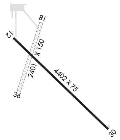
  • Runway Identifications
    Runway Identification: 12/30
    Length: 6550 ft
    Width: 75 ft
    Surface: CONCRETE
    Edge lights: Medium Intensity

    Treatment: GROOVED
    Weight: PCN 28 /R/B/W/T

     Runway: 12   Runway: 30
    Mag heading: 116°Mag heading: 296°
    Rwy Slope: 1.10% UpRwy Slope: -1.10% Down
    Approach: Approach:
    Pattern: Left TrafficPattern: Left Traffic
    Markings: NONPRECISION INSTRUMENTMarkings: NONPRECISION INSTRUMENT
    Marking Condition: GOODMarking Condition: GOOD
    Arresting Dev: Arresting Dev:
    Lat & Long: N4747.9  W10315.6Lat. & Long.: N4747.3  W10314.3
    Elev: 2063.1 ft. MSLElev: 2135.0 ft. MSL
    TCH: 43 ft. AGLTCH: 45 ft. AGL
    Visual Glide Path: 3.00 degreesVisual Glide Path: 3.00 degrees
    Displaced Threshold: 1023 feetDisplaced Threshold: 750 feet
    Touchdown Zone: YESTouchdown Zone: YES
    Touchdown Elev.: 2113.6 feetTouchdown Elev.: 2131.1 feet
    Visual Glide Slope: 2-Light PAPI on LEFT side of RunwayVisual Glide Slope: 2-Light PAPI on LEFT side of Runway
    RVR Equipment: RVR Equipment:
    RVV Equipment: NORVV Equipment: NO
    Approach Lights: Approach Lights:
    REIL: NOREIL: NO
    Centerline Lights: NOCenterline Lights: NO
    Touchdown lights: NOTouchdown lights: NO
    Runway Category: Runway with a Non-precision Approach having visibility minimums greater than 3/4 mileRunway Category: Runway with a Non-precision Approach having visibility minimums greater than 3/4 mile
    Declared Distances: TORA:5800' TODA:5800' ASDA:6550' LDA:5500'Declared Distances: TORA:5500' TODA:5500' ASDA:6400' LDA:5650'
    Obstructions: ROAD; ALSO +306 FT TWR 6600 FT FROM THR 4000 FT RIGHT OF CNTRLN EXTDD.Obstructions: ROAD
    Marked: NOT Marked/LightedMarked: LIGHTED; +167'HILL LGTD W/OBS LGTS.
    Clearance slope: 3:1Clearance slope: 21:1
    Obstruction height: 16 feet AGLObstruction height: 16 feet AGL
    Dist. from runway: 240 feetDist. from runway: 550 feet
    Centerline offset: 250 right of centerlineCenterline offset: 300 feet left of centerline
    Comments: Comments:
    C:8/P: