Current Weather/Notams (Metars, TAFs, Notams, NWS Forecast, PIREPS, and nearby weather)
Customs Information Send updates to Support@FltPlan.com
Customs Not Available
Database effective 04/18/2024
Airport Diagram might not be current.
|
| Facility Name: | SUNRIVER |
| City Name: | SUNRIVER |
| County: | DESCHUTES |
| State abbrev: | OR |
| State Name: | OREGON |
| | |
| Ownership: | PRIVATELY OWNED |
| Use: | OPEN TO THE PUBLIC |
| Owner's Name: | SUNRIVER RESORT, L.P. |
| Address: | PO BOX 3609 |
| | SUNRIVER, OR 97707 |
| Owner's Phone: | 541-593-1000 |
| | |
| Manager's Name: | BRANDON WRIGHT |
| Address: | 57200 RIVER ROAD |
| | SUNRIVER, OR 97707 |
| Phone: | 541-593-4603 |
| | |
| FAA Region: | NORTHWEST MOUNTAIN |
| FAA Field Office: | SEA |
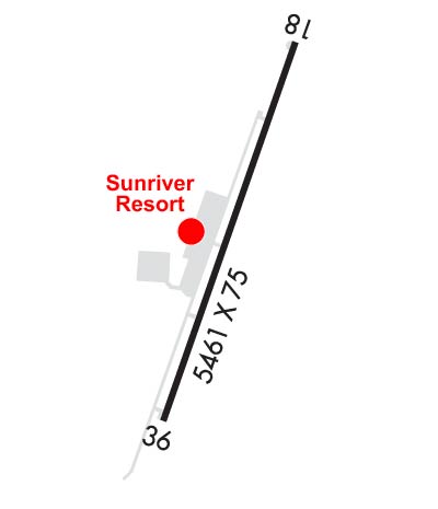
Runway Identifications
Runway Identification: 18/36Length: 5460 ft
Width: 75 ft
Surface: ASPHALT-FAIR CONDITION
Edge lights: Medium IntensityTreatment: NONE
| | Runway: 18 | | Runway: 36 |
| Mag heading: | 182° | Mag heading: | 2° |
| Rwy Slope: | .09% Up | Rwy Slope: | -.09% Down |
| Approach: | | Approach: | |
| Pattern: | Right Traffic | Pattern: | Left Traffic |
| Markings: | NONPRECISION INSTRUMENT | Markings: | BASIC |
| Marking Condition: | GOOD | Marking Condition: | GOOD; THRESHOLD LIGHTS LOCATED 148 FT NORTH OF ACTUAL RUNWAY END |
| Arresting Dev: | | Arresting Dev: | |
| Lat & Long: | N4353.0 W12127.0 | Lat. & Long.: | N4352.1 W12127.4 |
| Elev: | 4158.7 ft. MSL | Elev: | 4163.5 ft. MSL |
| TCH: | 45 ft. AGL | TCH: | 49 ft. AGL |
| Visual Glide Path: | 3.50 degrees | Visual Glide Path: | 3.50 degrees |
| Displaced Threshold: | 156 feet | Displaced Threshold: | No |
| Touchdown Zone: | YES | Touchdown Zone: | YES |
| Touchdown Elev.: | 4162.1 feet | Touchdown Elev.: | 4163.5 feet |
| Visual Glide Slope: | 4-Light PAPI on LEFT side of Runway | Visual Glide Slope: | 4-Light PAPI on LEFT side of Runway |
| RVR Equipment: | | RVR Equipment: | |
| RVV Equipment: | NO | RVV Equipment: | NO |
| Approach Lights: | | Approach Lights: | |
| REIL: | YES | REIL: | YES |
| Centerline Lights: | NO | Centerline Lights: | NO |
| Touchdown lights: | NO | Touchdown lights: | NO |
| Runway Category: | Runway with a Non-precision Approach | Runway Category: | Runway with a Visual Approach |
| Declared Distances: | | Declared Distances: | |
| Obstructions: | | Obstructions: | TREES |
| Marked: | | Marked: | NOT Marked/Lighted |
| Clearance slope: | 34:1; RWY 18 APCH RATIO 54:1 BASED ON DSPLCD THLD; +70 FT TREES 4000 FT ON CNTRLN. | Clearance slope: | 22:1 |
| Obstruction height: | | Obstruction height: | 80 feet AGL |
| Dist. from runway: | | Dist. from runway: | 2000 feet |
| Centerline offset: | | Centerline offset: | 150B |
| Comments: | | Comments: | |

