Click here for more info on on SMS!

KS05

BANDON STATE
BANDON
OR
Time Zone: Pacific
Lat: N 4305.2
Long: W 12424.5
Elev: 122
Var: -18
Longest Runway: 3601
CTAF: 122.8

FBO & Flight Services info for KS05

FBOs: Update your Fuel Prices

BANDON AVIATIONPh: 541-347-2022 Fax: 541-347-9261 Freq: 122.8
Service
Jet
100LL
SAF
MoGas
Full        Caution: Fuel prices have not been updated in 59 days.
Last Update: 02/27/2024 11:43

Self  7.25    
 Address: 8711 KEHL ROAD   BANDON OR 97411
If you are an FBO, call 1-203-262-1700 to update your info or email: FltPlan.Advertising@garmin.com
Advertise your FBO on FltPlan.com

Runway & Approach Info for KS05
Rwy
Length
Land Dist**
Approach*
  Rwy
Length
Land Dist**
Approach*
16
3601x60  3601'          
 
  
34
  3601x60  3601'          
 
 * only ILS, LOC, LDA, and SDF approaches to a specific runway are shown
** For any Declared Landing Distance Available, please see A/FD or Approach plates
Runway Weight Capability (lbs.) Help
Runway IDSingle WheelDouble WheelDouble Tandem WheelDual Double Wheel
16/3412,000N/AN/AN/A
These numbers are Advisory and are not limits.   The Airport Manager should have more accurate Weight Limits
Approach Charts
FltPlan does not have IFR approach charts available for KS05.
Current Weather/Notams
Customs Information Send updates to Support@FltPlan.com
Customs Not Available
Database effective 05/16/2024
Airport Diagram of KS05
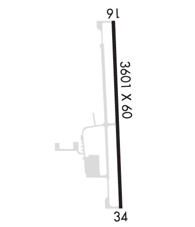
Airport Diagram might not be current.

Facility Name: BANDON STATE
City Name: BANDON
County: COOS
State abbrev: OR
State Name: OREGON
   
Ownership: PUBLICLY OWNED
Use: OPEN TO THE PUBLIC
Owner's Name: OREGON DEPT. OF AVIATION
Address: 3040 25TH ST SE
 SALEM, OR 97302-1125
Owner's Phone: 503-378-4880
  
Manager's Name: STATE AIRPORTS MGR
Address: 3040 25TH ST SE
 SALEM, OR 97302-1125
Phone: 503-378-4880
   
FAA Region: NORTHWEST MOUNTAIN
FAA Field Office: SEA


Sunrise / Sunset times for BANDON STATE

DateSunriseSunset
04/25/24 Thursday6:1920:13
04/26/24 Friday6:1720:14
04/27/24 Saturday6:1620:15
04/28/24 Sunday6:1420:16
04/29/24 Monday6:1320:18
04/30/24 Tuesday6:1120:19
05/01/24 Wednesday6:1020:20
05/02/24 Thursday6:0920:21
05/03/24 Friday6:0720:22
05/04/24 Saturday6:0620:23
05/05/24 Sunday6:0520:24
05/06/24 Monday6:0320:26
05/07/24 Tuesday6:0220:27
05/08/24 Wednesday6:0120:28

Airport Facilities

Airport Attendance Schedule7 Days A Week 0700-1800
Airport Status OPERATIONAL (This Status can change at any time - please check NOTAMS)
Airport Lighting ScheduleACTVT MIRL RY 16/34; REIL RYS 16 & 34 AND PAPI RYS 16/34 - CTAF.
Airport Storage AvailableTie Downs
Extra Services AvailableFlight Instruction, Aircraft Rental, Aircraft Sales
Wind IndicatorYES - (lighted)
Control TowerNO
CTAF Frequency122.800
Unicom Frequency122.800
Rotating Beacon ColorWG
Segmented CircleYES
Landing FeeNO

Airport Inspection Data

Airport InspectedSTATE - performed by STATE AERONAUTICAL PERSONNEL
Inspection Date02/16/2024

Airport Services

Type of Fuel AvailableGrade 100LL
Airframe Repair ServiceMAJOR
Power Plant Repair ServiceMAJOR

Geographic Data

LatitudeN4305.2
LongitudeW12424.5 (ESTIMATED)
Arpt Elevation122ft (SURVEYED)
Magnetic Variation18E
2 miles SEof BANDON
Traffic Pattern Altitude
Sectional ChartKLAMATH FALLS

Aircraft Data

Operations (Reported)YearlyAvg. Daily
General Aviation Transient 30008
General Aviation Local 350010
Air Taxi 5001
Commerical 00
Commuter 00
Military 1000
Aircraft based on Field
General Aviation Singles 26
General Aviation Multi 4
Jet Aircraft 0
General Aviation Helicopters 1
Military Aircraft 0
Gliders 0
Ultralights 0

FAA Services

FSS on field NO
FSS tie-in MC MINNVILLE
FSS Phone 1-800-WX-BRIEF
Who issues Notams MMV
Notam D service at airport YES
ARTCC Name SEATTLE

Federal Status

Airport Certification
Aircraft Rescue & Firefighting IndexNone
Airport of EntryNo
Custom Landing RightsNo
Joint Civil/MilitaryNo
Military Landing rightsNo

Federal Agreements

NATIONAL PLAN OF INTEGRATED AIRPORT SYSTEMS (NPIAS)
GRANT AGREEMENTS UNDER FAAP/ADAP/AIP
ASSURANCES PURSUANT TO TITLE VI, CIVIL RIGHTS ACT OF 1964

Remarks

TWY MKD WITH BLUE REFLECTORS.
DEER INVOF RY & ARPT.
FOR CD CTC SEATTLE ARTCC AT 253-351-3694.
SFC CONDS NOT RPRTD.
Runway Identifications
Runway Identification: 16/34
Length: 3601 ft
Width: 60 ft
Surface: ASPHALT-GOOD CONDITION
Edge lights: Medium Intensity

Treatment: NONE

 Runway: 16   Runway: 34
Mag heading: 160°Mag heading: 340°
Rwy Slope: .47% UpRwy Slope: -.47% Down
Approach: Approach:
Pattern: Left TrafficPattern: Left Traffic
Markings: NONPRECISION INSTRUMENTMarkings: NONPRECISION INSTRUMENT
Marking Condition: GOODMarking Condition: GOOD
Arresting Dev: Arresting Dev:
Lat & Long: N4305.5  W12424.5Lat. & Long.: N4304.9  W12424.5
Elev: 105.1 ft. MSLElev: 122.1 ft. MSL
TCH: 55 ft. AGLTCH: 42 ft. AGL
Visual Glide Path: 4.00 degreesVisual Glide Path: 4.00 degrees
Displaced Threshold: NoDisplaced Threshold: No
Touchdown Zone: YESTouchdown Zone: YES
Touchdown Elev.: 120.4 feetTouchdown Elev.: 122.1 feet
Visual Glide Slope: 4-Light PAPI on LEFT side of RunwayVisual Glide Slope: 4-Light PAPI on LEFT side of Runway; UNUSBL BYD 7 DEGS RIGHT OF CNTRLN
RVR Equipment: RVR Equipment:
RVV Equipment: NORVV Equipment: NO
Approach Lights: Approach Lights:
REIL: YESREIL: YES
Centerline Lights: NOCenterline Lights: NO
Touchdown lights: NOTouchdown lights: NO
Runway Category: Runway with a Visual ApproachRunway Category: Runway with a Visual Approach
Declared Distances: Declared Distances:
Obstructions: Obstructions: TREES
Marked: Marked: NOT Marked/Lighted
Clearance slope: 20:1Clearance slope: 14:1
Obstruction height: Obstruction height: 97 feet AGL
Dist. from runway: Dist. from runway: 1614 feet
Centerline offset: Centerline offset:
Comments: Comments:
C:4/P: