Current Weather/Notams (Metars, TAFs, Notams, NWS Forecast, PIREPS, and nearby weather)
Customs Information Send updates to Support@FltPlan.com
Customs Not Available
Database effective 05/16/2024
Airport Diagram might not be current.
|
| Facility Name: | ROSS COUNTY |
| City Name: | CHILLICOTHE |
| County: | ROSS |
| State abbrev: | OH |
| State Name: | OHIO |
| | |
| Ownership: | PUBLICLY OWNED |
| Use: | OPEN TO THE PUBLIC |
| Owner's Name: | ROSS COUNTY BOARD OF COMM |
| Address: | 2 N PAINT ST STE H |
| | CHILLICOTHE, OH 45601-3109 |
| Owner's Phone: | 740-702-3085 |
| | |
| Manager's Name: | JAMES PARKS; TRM@HORIZONVIEW.NET. |
| Address: | 1296 STONE RD |
| | CHILLICOTHE, OH 45601-9739 |
| Phone: | 740-773-4788 |
| | |
| FAA Region: | GREAT LAKES |
| FAA Field Office: | DET |
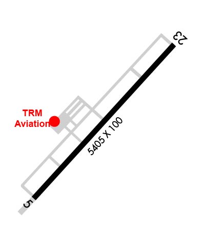
Runway Identifications
Runway Identification: 05/23Length: 5405 ft
Width: 100 ft
Surface: ASPHALT-GOOD CONDITION
Edge lights: Medium IntensityTreatment: NONE
| | Runway: 05 | | Runway: 23 |
| Mag heading: | 47° | Mag heading: | 227° |
| Rwy Slope: | -.38% Down | Rwy Slope: | .38% Up |
| Approach: | | Approach: | |
| Pattern: | Left Traffic | Pattern: | Left Traffic |
| Markings: | NONPRECISION INSTRUMENT | Markings: | NONPRECISION INSTRUMENT |
| Marking Condition: | FAIR | Marking Condition: | FAIR |
| Arresting Dev: | | Arresting Dev: | |
| Lat & Long: | N3926.1 W08301.8 | Lat. & Long.: | N3926.8 W08301.0 |
| Elev: | 724.9 ft. MSL | Elev: | 704.5 ft. MSL |
| TCH: | 44 ft. AGL | TCH: | 45 ft. AGL |
| Visual Glide Path: | 3.00 degrees | Visual Glide Path: | 3.00 degrees |
| Displaced Threshold: | No | Displaced Threshold: | No |
| Touchdown Zone: | YES | Touchdown Zone: | YES |
| Touchdown Elev.: | 725.0 feet | Touchdown Elev.: | 716.3 feet |
| Visual Glide Slope: | 4-Light PAPI on LEFT side of Runway | Visual Glide Slope: | 4-Light PAPI on LEFT side of Runway |
| RVR Equipment: | | RVR Equipment: | |
| RVV Equipment: | NO | RVV Equipment: | NO |
| Approach Lights: | | Approach Lights: | |
| REIL: | YES | REIL: | YES |
| Centerline Lights: | NO | Centerline Lights: | NO |
| Touchdown lights: | NO | Touchdown lights: | NO |
| Runway Category: | Runway with a Visual Approach | Runway Category: | Runway with a Non-precision Approach having visibility minimums greater than 3/4 mile |
| Declared Distances: | | Declared Distances: | |
| Obstructions: | TREES | Obstructions: | TREES |
| Marked: | NOT Marked/Lighted | Marked: | NOT Marked/Lighted |
| Clearance slope: | 17:1 | Clearance slope: | 21:1 |
| Obstruction height: | 75 feet AGL | Obstruction height: | 40 feet AGL |
| Dist. from runway: | 1510 feet | Dist. from runway: | 1050 feet |
| Centerline offset: | 215 left of centerline | Centerline offset: | 380 feet left of centerline |
| Comments: | | Comments: | |