Current Weather/Notams (Metars, TAFs, Notams, NWS Forecast, PIREPS, and nearby weather)
Customs Information Send updates to Support@FltPlan.com
Customs Not Available
Database effective 05/16/2024
Airport Diagram might not be current.
|
| Facility Name: | BURNETT COUNTY |
| City Name: | SIREN |
| County: | BURNETT |
| State abbrev: | WI |
| State Name: | WISCONSIN |
| | |
| Ownership: | PUBLICLY OWNED |
| Use: | OPEN TO THE PUBLIC |
| Owner's Name: | BURNETT COUNTY |
| Address: | 7410 CTH K |
| | SIREN, WI 54872 |
| Owner's Phone: | 715-349-2904 |
| | |
| Manager's Name: | NATHAN EHALT |
| Address: | 7410 CTH K, SUITE #116; EMAIL ADDRESS: NEHALT@BURNETTCOUNTY.ORG (ALL LOWER CASE) |
| | SIREN, WI 54872 |
| Phone: | 715-222-1702; AFT HRS CALL 715-222-1702 OR 715-566-2557. |
| | |
| FAA Region: | GREAT LAKES |
| FAA Field Office: | CHI |
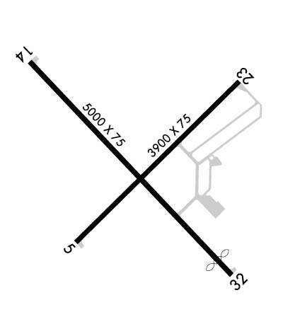
Runway Identifications
Runway Identification: 05/23Length: 3900 ft
Width: 75 ft
Surface: ASPHALT
Edge lights: Medium IntensityTreatment: NONE
| | Runway: 05 | | Runway: 23 |
| Mag heading: | 46° | Mag heading: | 226° |
| Rwy Slope: | -.13% Down | Rwy Slope: | .13% Up |
| Approach: | | Approach: | |
| Pattern: | Left Traffic | Pattern: | Left Traffic |
| Markings: | NONPRECISION INSTRUMENT | Markings: | NONPRECISION INSTRUMENT |
| Marking Condition: | GOOD | Marking Condition: | GOOD |
| Arresting Dev: | | Arresting Dev: | |
| Lat & Long: | N4549.2 W09222.7 | Lat. & Long.: | N4549.6 W09222.0 |
| Elev: | 989.2 ft. MSL | Elev: | 984.0 ft. MSL |
| TCH: | 31 ft. AGL | TCH: | 27 ft. AGL |
| Visual Glide Path: | 3.50 degrees | Visual Glide Path: | 3.00 degrees |
| Displaced Threshold: | No | Displaced Threshold: | No |
| Touchdown Zone: | YES | Touchdown Zone: | YES |
| Touchdown Elev.: | 989.3 feet | Touchdown Elev.: | 988.5 feet |
| Visual Glide Slope: | 2-Light PAPI on LEFT side of Runway; UNUSBL BYD 5 DEGS RIGHT OF CNTRLN. | Visual Glide Slope: | 2-Light PAPI on LEFT side of Runway |
| RVR Equipment: | | RVR Equipment: | |
| RVV Equipment: | NO | RVV Equipment: | NO |
| Approach Lights: | | Approach Lights: | |
| REIL: | YES | REIL: | YES |
| Centerline Lights: | NO | Centerline Lights: | NO |
| Touchdown lights: | NO | Touchdown lights: | NO |
| Runway Category: | Runway with a Non-precision Approach | Runway Category: | Runway with a Non-precision Approach |
| Declared Distances: | | Declared Distances: | |
| Obstructions: | | Obstructions: | ROAD |
| Marked: | | Marked: | LIGHTED |
| Clearance slope: | 20:1 | Clearance slope: | 12:1 |
| Obstruction height: | | Obstruction height: | 15 feet AGL |
| Dist. from runway: | | Dist. from runway: | 382 feet |
| Centerline offset: | | Centerline offset: | 277 feet left of centerline |
| Comments: | | Comments: | |
Runway Identification: 14/32Length: 5000 ft
Width: 75 ft
Surface: ASPHALT-GOOD CONDITION
Edge lights: Medium IntensityTreatment: NONE
| | Runway: 14 | | Runway: 32 |
| Mag heading: | 138° | Mag heading: | 318° |
| Rwy Slope: | .01% Up | Rwy Slope: | -.01% Down |
| Approach: | | Approach: | |
| Pattern: | Left Traffic | Pattern: | Left Traffic |
| Markings: | NONPRECISION INSTRUMENT | Markings: | NONPRECISION INSTRUMENT |
| Marking Condition: | GOOD | Marking Condition: | GOOD |
| Arresting Dev: | | Arresting Dev: | |
| Lat & Long: | N4549.7 W09222.9 | Lat. & Long.: | N4549.1 W09222.1 |
| Elev: | 987.2 ft. MSL | Elev: | 987.6 ft. MSL |
| TCH: | 28 ft. AGL | TCH: | 38 ft. AGL |
| Visual Glide Path: | 3.00 degrees | Visual Glide Path: | 4.00 degrees |
| Displaced Threshold: | No | Displaced Threshold: | 340 feet |
| Touchdown Zone: | YES | Touchdown Zone: | YES |
| Touchdown Elev.: | 988.0 feet | Touchdown Elev.: | 988.0 feet |
| Visual Glide Slope: | 2-Light PAPI on LEFT side of Runway | Visual Glide Slope: | 2-Light PAPI on LEFT side of Runway |
| RVR Equipment: | | RVR Equipment: | |
| RVV Equipment: | NO | RVV Equipment: | NO |
| Approach Lights: | | Approach Lights: | |
| REIL: | YES | REIL: | YES |
| Centerline Lights: | NO | Centerline Lights: | NO |
| Touchdown lights: | NO | Touchdown lights: | NO |
| Runway Category: | Runway with a Non-precision Approach | Runway Category: | Runway with a Non-precision Approach |
| Declared Distances: | | Declared Distances: | |
| Obstructions: | | Obstructions: | TREES |
| Marked: | | Marked: | NOT Marked/Lighted |
| Clearance slope: | 20:1 | Clearance slope: | 15:1; APCH RATIO 20:1 TO DSPLCD THR. |
| Obstruction height: | | Obstruction height: | 78 feet AGL |
| Dist. from runway: | | Dist. from runway: | 1378 feet |
| Centerline offset: | | Centerline offset: | 115 feet left of centerline |
| Comments: | | Comments: | |

