Current Weather/Notams (Metars, TAFs, Notams, NWS Forecast, PIREPS, and nearby weather)
Customs Information Send updates to Support@FltPlan.com
Customs Not Available
Database effective 05/16/2024
Airport Diagram might not be current.
|
| Facility Name: | JASPER COUNTY |
| City Name: | RENSSELAER |
| County: | JASPER |
| State abbrev: | IN |
| State Name: | INDIANA |
| | |
| Ownership: | PUBLICLY OWNED |
| Use: | OPEN TO THE PUBLIC |
| Owner's Name: | JASPER COUNTY AIRPORT AUTHORITY |
| Address: | 2326 W. CLARK ST. |
| | RENSSELAER, IN 47978 |
| Owner's Phone: | 219-866-2100 |
| | |
| Manager's Name: | EMILY HACKLER |
| Address: | 2326 W. CLARK ST. |
| | RENSSELAER, IN 47978 |
| Phone: | 219-866-2100; 219-869-5103. |
| | |
| FAA Region: | GREAT LAKES |
| FAA Field Office: | CHI |
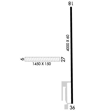
Runway Identifications
Runway Identification: 09/27Length: 1450 ft
Width: 150 ft
Surface: GRASS-GOOD CONDITION
Edge lights: Treatment: NONE
| | Runway: 09 | | Runway: 27 |
| Mag heading: | 91° | Mag heading: | 271° |
| Rwy Slope: | .36% Up | Rwy Slope: | -.36% Down |
| Approach: | | Approach: | |
| Pattern: | Left Traffic | Pattern: | Left Traffic |
| Markings: | NONE | Markings: | NONE |
| Marking Condition: | ORANGE CONES. | Marking Condition: | ORANGE CONES. |
| Arresting Dev: | | Arresting Dev: | |
| Lat & Long: | N4056.9 W08711.3 | Lat. & Long.: | N4056.9 W08711.0 |
| Elev: | 678.9 ft. MSL | Elev: | 684.1 ft. MSL |
| TCH: | | TCH: | |
| Visual Glide Path: | | Visual Glide Path: | |
| Displaced Threshold: | No | Displaced Threshold: | No |
| Touchdown Zone: | YES | Touchdown Zone: | YES |
| Touchdown Elev.: | 684.1 feet | Touchdown Elev.: | 684.1 feet |
| Visual Glide Slope: | | Visual Glide Slope: | |
| RVR Equipment: | | RVR Equipment: | |
| RVV Equipment: | NO | RVV Equipment: | NO |
| Approach Lights: | | Approach Lights: | |
| REIL: | NO | REIL: | NO |
| Centerline Lights: | NO | Centerline Lights: | NO |
| Touchdown lights: | NO | Touchdown lights: | NO |
| Runway Category: | Runway with a Visual Approach | Runway Category: | Runway with a Visual Approach |
| Declared Distances: | | Declared Distances: | |
Runway Identification: 18/36Length: 4000 ft
Width: 60 ft
Surface: CONCRETE-GOOD CONDITION
Edge lights: Medium IntensityTreatment: NONE
| | Runway: 18 | | Runway: 36 |
| Mag heading: | 182° | Mag heading: | 2° |
| Rwy Slope: | -.60% Down | Rwy Slope: | .60% Up |
| Approach: | | Approach: | |
| Pattern: | Left Traffic | Pattern: | Left Traffic |
| Markings: | NONPRECISION INSTRUMENT | Markings: | NONPRECISION INSTRUMENT |
| Marking Condition: | FAIR | Marking Condition: | FAIR |
| Arresting Dev: | | Arresting Dev: | |
| Lat & Long: | N4057.2 W08710.9 | Lat. & Long.: | N4056.5 W08710.9 |
| Elev: | 698.2 ft. MSL | Elev: | 674.4 ft. MSL |
| TCH: | 27 ft. AGL | TCH: | 43 ft. AGL |
| Visual Glide Path: | 3.00 degrees | Visual Glide Path: | 3.00 degrees |
| Displaced Threshold: | No | Displaced Threshold: | No |
| Touchdown Zone: | YES | Touchdown Zone: | YES |
| Touchdown Elev.: | 698.2 feet | Touchdown Elev.: | 681.3 feet |
| Visual Glide Slope: | 2-Light PAPI on LEFT side of Runway | Visual Glide Slope: | 2-Light PAPI on LEFT side of Runway |
| RVR Equipment: | | RVR Equipment: | |
| RVV Equipment: | NO | RVV Equipment: | NO |
| Approach Lights: | | Approach Lights: | |
| REIL: | YES | REIL: | YES |
| Centerline Lights: | NO | Centerline Lights: | NO |
| Touchdown lights: | NO | Touchdown lights: | NO |
| Runway Category: | Runway with a Non-precision Approach | Runway Category: | Runway with a Non-precision Approach |
| Declared Distances: | | Declared Distances: | |
| Obstructions: | ROAD | Obstructions: | ROAD |
| Marked: | NOT Marked/Lighted | Marked: | NOT Marked/Lighted |
| Clearance slope: | 20:1 | Clearance slope: | 21:1 |
| Obstruction height: | 29 feet AGL | Obstruction height: | 15 feet AGL |
| Dist. from runway: | 790 feet | Dist. from runway: | 520 feet |
| Centerline offset: | | Centerline offset: | |
| Comments: | | Comments: | CROPS 120 FT R OF CNTRLN AT THR; ROAD 245 FT R OF CNTRLN. TIE-DOWN AREA 100 FT FM RWY END 130 FT L OF CNTRLN. |

