Current Weather/Notams (Metars, TAFs, Notams, NWS Forecast, PIREPS, and nearby weather)
Customs Information Send updates to Support@FltPlan.com
Customs Not Available
Database effective 05/16/2024
Airport Diagram might not be current.
|
| Facility Name: | WATERTOWN MUNI |
| City Name: | WATERTOWN |
| County: | JEFFERSON |
| State abbrev: | WI |
| State Name: | WISCONSIN |
| | |
| Ownership: | PUBLICLY OWNED |
| Use: | OPEN TO THE PUBLIC |
| Owner's Name: | CITY OF WATERTOWN |
| Address: | 106 JONES |
| | WATERTOWN, WI 53094 |
| Owner's Phone: | 920-262-4000 |
| | |
| Manager's Name: | JEFF BAUM |
| Address: | 1741 RIVER DRIVE |
| | WATERTOWN, WI 53094 |
| Phone: | 920-261-4567 |
| | |
| FAA Region: | GREAT LAKES |
| FAA Field Office: | CHI |
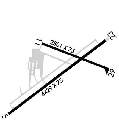
Runway Identifications
Runway Identification: 05/23Length: 4429 ft
Width: 75 ft
Surface: ASPHALT-FAIR CONDITION
Edge lights: Medium IntensityTreatment: NONE
| | Runway: 05 | | Runway: 23 |
| Mag heading: | 54° | Mag heading: | 234° |
| Rwy Slope: | .12% Up | Rwy Slope: | -.12% Down |
| Approach: | | Approach: | |
| Pattern: | Right Traffic | Pattern: | Left Traffic |
| Markings: | NONPRECISION INSTRUMENT | Markings: | NONPRECISION INSTRUMENT |
| Marking Condition: | FAIR | Marking Condition: | FAIR |
| Arresting Dev: | | Arresting Dev: | |
| Lat & Long: | N4309.9 W08843.8 | Lat. & Long.: | N4310.3 W08843.0 |
| Elev: | 817.4 ft. MSL | Elev: | 822.9 ft. MSL |
| TCH: | 50 ft. AGL | TCH: | 45 ft. AGL |
| Visual Glide Path: | 3.00 degrees | Visual Glide Path: | 3.00 degrees |
| Displaced Threshold: | 190 feet | Displaced Threshold: | No |
| Touchdown Zone: | YES | Touchdown Zone: | YES |
| Touchdown Elev.: | 821.0 feet | Touchdown Elev.: | 823.0 feet |
| Visual Glide Slope: | 2-Light PAPI on LEFT side of Runway | Visual Glide Slope: | 2-Light PAPI on LEFT side of Runway |
| RVR Equipment: | | RVR Equipment: | |
| RVV Equipment: | NO | RVV Equipment: | NO |
| Approach Lights: | | Approach Lights: | |
| REIL: | YES | REIL: | YES |
| Centerline Lights: | NO | Centerline Lights: | NO |
| Touchdown lights: | NO | Touchdown lights: | NO |
| Runway Category: | Runway with a Non-precision Approach | Runway Category: | Runway with a Non-precision Approach |
| Declared Distances: | TORA:4430' TODA:5110' ASDA:4550' LDA:4430' | Declared Distances: | TORA:4430' TODA:4845' ASDA:4430' LDA:4430' |
| Obstructions: | TREE | Obstructions: | TREE |
| Marked: | NOT Marked/Lighted | Marked: | NOT Marked/Lighted |
| Clearance slope: | 18:1; APCH RATIO 23:1 TO DSPLCD THR. | Clearance slope: | 16:1 |
| Obstruction height: | 40 feet AGL | Obstruction height: | 76 feet AGL |
| Dist. from runway: | 950 feet | Dist. from runway: | 1450 feet |
| Centerline offset: | 15 right of centerline | Centerline offset: | 400 feet right of centerline |
| Comments: | | Comments: | |
Runway Identification: 11/29Length: 2801 ft
Width: 75 ft
Surface: ASPHALT-FAIR CONDITION
Edge lights: Medium IntensityTreatment: NONE
| | Runway: 11 | | Runway: 29 |
| Mag heading: | 113° | Mag heading: | 293° |
| Rwy Slope: | .36% Up | Rwy Slope: | -.36% Down |
| Approach: | | Approach: | |
| Pattern: | Right Traffic | Pattern: | Left Traffic |
| Markings: | NONPRECISION INSTRUMENT | Markings: | NONPRECISION INSTRUMENT |
| Marking Condition: | FAIR | Marking Condition: | FAIR |
| Arresting Dev: | | Arresting Dev: | |
| Lat & Long: | N4310.3 W08843.6 | Lat. & Long.: | N4310.2 W08843.0 |
| Elev: | 822.8 ft. MSL | Elev: | 832.9 ft. MSL |
| TCH: | | TCH: | |
| Visual Glide Path: | | Visual Glide Path: | |
| Displaced Threshold: | No | Displaced Threshold: | No |
| Touchdown Zone: | YES | Touchdown Zone: | YES |
| Touchdown Elev.: | 832.9 feet | Touchdown Elev.: | 832.9 feet |
| Visual Glide Slope: | | Visual Glide Slope: | |
| RVR Equipment: | | RVR Equipment: | |
| RVV Equipment: | NO | RVV Equipment: | NO |
| Approach Lights: | | Approach Lights: | |
| REIL: | NO | REIL: | NO |
| Centerline Lights: | NO | Centerline Lights: | NO |
| Touchdown lights: | NO | Touchdown lights: | NO |
| Runway Category: | Runway with a Non-precision Approach | Runway Category: | Runway with a Non-precision Approach |
| Declared Distances: | | Declared Distances: | |
| Obstructions: | TREES | Obstructions: | TREE |
| Marked: | NOT Marked/Lighted | Marked: | NOT Marked/Lighted |
| Clearance slope: | 16:1 | Clearance slope: | 14:1 |
| Obstruction height: | 42 feet AGL | Obstruction height: | 64 feet AGL |
| Dist. from runway: | 900 feet | Dist. from runway: | 1100 feet |
| Centerline offset: | 225 left of centerline | Centerline offset: | 350 feet right of centerline |
| Comments: | | Comments: | |

