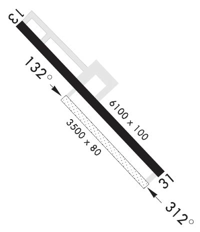
Click here for more info on on SMS!

KRYM

RAY S MILLER AAF (NG)
CAMP RIPLEY
MN
Time Zone: Central
Lat: N 4605.4
Long: W 09421.6
Elev: 1150
Var: -03
Longest Runway: 6100
Clr Del: 126.2
Tower: 126.2

FBO & Flight Services info for KRYM

FBOs: Update your Fuel Prices

AWOSPh: 320-632-7500
-
-
 
If you are an FBO, call 1-203-262-1700 to update your info or email: FltPlan.Advertising@garmin.com
Advertise your FBO on FltPlan.com

Runway & Approach Info for KRYM
Rwy
Length
Land Dist**
Approach*
  Rwy
Length
Land Dist**
Approach*
13
6100x100  6100'          
 
  
31
  6100x100  6100'          
ILS/DME
 111.10 - 312°  
132
3500x80  3500'          
 
  
312
  3500x80  3500'          
 
15
880x50  880'          
 
  
33
  880x50  880'          
 
 * only ILS, LOC, LDA, and SDF approaches to a specific runway are shown
** For any Declared Landing Distance Available, please see A/FD or Approach plates
Runway Weight Capability (lbs.) Help
Runway IDSingle WheelDouble WheelDouble Tandem WheelDual Double Wheel
13/31N/AN/AN/AN/A
132/312N/AN/AN/AN/A
15/33N/AN/AN/AN/A
H1N/AN/AN/AN/A
H2N/AN/AN/AN/A
H3N/AN/AN/AN/A
H4N/AN/AN/AN/A
These numbers are Advisory and are not limits.   The Airport Manager should have more accurate Weight Limits
Approach Charts
Approaches    
Current Weather/Notams
Customs Information Send updates to Support@FltPlan.com
Customs Not Available
Database effective 05/16/2024
Airport Diagram of KRYM
Airport Diagram might not be current.

Facility Name: RAY S MILLER AAF
City Name: CAMP RIPLEY
County: MORRISON
State abbrev: MN
State Name: MINNESOTA
   
Ownership: ARMY OWNED
Use: PRIVATE
Owner's Name: US ARMY AERONAUTICAL SVCS AGENCY
Address:
 FT BELVOIR, VA 22060
Owner's Phone:
  
Manager's Name: MICHAEL GUIDRY
Address:
 
Phone: 320-616-2780
   
FAA Region: GREAT LAKES
FAA Field Office: DMA


Sunrise / Sunset times for RAY S MILLER AAF

DateSunriseSunset
04/22/24 Monday6:1720:15
04/23/24 Tuesday6:1620:16
04/24/24 Wednesday6:1420:18
04/25/24 Thursday6:1220:19
04/26/24 Friday6:1120:20
04/27/24 Saturday6:0920:22
04/28/24 Sunday6:0820:23
04/29/24 Monday6:0620:24
04/30/24 Tuesday6:0420:25
05/01/24 Wednesday6:0320:27
05/02/24 Thursday6:0120:28
05/03/24 Friday6:0020:29
05/04/24 Saturday5:5820:31
05/05/24 Sunday5:5720:32

Airport Facilities

Airport Attendance ScheduleMON-FRI 1300-0500Z; CLSD HOL.
Airport Status OPERATIONAL (This Status can change at any time - please check NOTAMS)
Airport Lighting ScheduleACTVT MALSF RWY 31; HIRL RWY 13/31 - 126.2. MALSF RWY 31 & HIRL RWY 13/31 PRESET TO LOW INTST; INCR INTST - 126.2.
Airport Storage AvailableNONE
Extra Services AvailableNONE
Wind IndicatorNONE
Control TowerYES
CTAF Frequency
Unicom Frequency
Rotating Beacon Color
Segmented CircleNO
Landing Fee

Airport Inspection Data

Airport InspectedNo Inspection Data Available performed by the OWNER
Inspection DateUnknown

Airport Services

Type of Fuel AvailableNone
Airframe Repair ServiceNone
Power Plant Repair ServiceNone

Geographic Data

LatitudeN4605.4
LongitudeW09421.6 (ESTIMATED)
Arpt Elevation1149ft (ESTIMATED)
Magnetic Variation03E
1 miles NWof CAMP RIPLEY
Traffic Pattern Altitude
Sectional ChartTWIN CITIES

Aircraft Data

Operations (Reported)YearlyAvg. Daily
General Aviation Transient 00
General Aviation Local 00
Air Taxi 00
Commerical 00
Commuter 00
Military 00
Aircraft based on Field
General Aviation Singles 0
General Aviation Multi 0
Jet Aircraft 0
General Aviation Helicopters 0
Military Aircraft 0
Gliders 0
Ultralights 0

FAA Services

FSS on field NO
FSS tie-in PRINCETON
FSS Phone 1-800-WX-BRIEF
Who issues Notams RYM
Notam D service at airport YES
ARTCC Name MINNEAPOLIS

Federal Status

Airport Certification
Aircraft Rescue & Firefighting IndexNone
Airport of EntryNo
Custom Landing RightsNo
Joint Civil/MilitaryNo
Military Landing rightsNo

Remarks

FUEL: F24
RSTD: PPR - BASE OPS DSN 871-2779; C320-616-2779; TOWER C320-616-2781.
CAUTION: RWY EDGE LGT PSN 25 FT FM USBL RWY SFC.
NOISE ABATEMENT PROC IN EFCT.
MISC: PRK AREA CAP DESIGNED FOR 3 C130 ACFT SIMULTANEOUSLY. ASSAULT STRIP MRK CNTR 3500 FT OF RWY 750 FT OVRN BOTH ENDS. CTC BASE OPS FOR ASSAULT STRIP COND.
OPR AGENCY ARNG.
CAUTION: WILDLIFE HAZ.
CAUTION: OCNL UAS OPS - CK NOTAM.
MISC: PPR FOR LTD AVBL SVC ON WKEND.
MISC: LTD FIXED WING TSNT PRKG.
MISC: FOR WINTER RWY COND - C320-616-2779.
RSTD; RWY 15/33 FOR UNMANNED ACFT USE ONLY.
RWY 132/ 312ASSULT STRIP.
Airport Communications & Frequencies:
MILLER Tower Frequencies:   Hours(local) of operation: 1300-0445Z++ MON-THU, 1400-2200Z++ FRI, CLSD HOL.   
126.2
254.4
Clearance Delivery Frequencies:
126.2
Emergency Frequencies:
243.0
Remarks
  • APCH/DEP SVC PRVDD BY MINNEAPOLIS ARTCC ON FREQS 118.05/239.0 (BRAINERD RCAG).
  • Runway Identifications
    Runway Identification: 13/31
    Length: 6100 ft
    Width: 100 ft
    Surface: ASPHALT
    Edge lights: High Intensity

    Treatment: NONE
    Weight: PCN 40 /F/A/W/T

     Runway: 13   Runway: 31
    Mag heading: N/AMag heading: N/A
    Rwy Slope: -.10% DownRwy Slope: .10% Up
    Approach: Approach: ILS/DME
    Pattern: Left TrafficPattern: Left Traffic
    Markings: PRECISION INSTRUMENTMarkings: PRECISION INSTRUMENT
    Marking Condition: GOODMarking Condition: GOOD
    Arresting Dev: Arresting Dev:
    Lat & Long: N4605.8  W09422.1Lat. & Long.: N4605.1  W09421.1
    Elev: 1149.5 ft. MSLElev: 1143.4 ft. MSL
    TCH: TCH:
    Visual Glide Path: Visual Glide Path:
    Displaced Threshold: NoDisplaced Threshold: No
    Touchdown Zone: YESTouchdown Zone: YES
    Touchdown Elev.: 1149.5 feetTouchdown Elev.: 1146.4 feet
    Visual Glide Slope: Visual Glide Slope:
    RVR Equipment: RVR Equipment:
    RVV Equipment: NORVV Equipment: NO
    Approach Lights: Approach Lights: MALSF - 1,400 foot medium intensity approach lighting system with sequenced flashers
    REIL: NOREIL: NO
    Centerline Lights: NOCenterline Lights: NO
    Touchdown lights: NOTouchdown lights: NO
    Runway Category: Runway with a Non-precision Approach having visibility minimums greater than 3/4 mileRunway Category: Precision Instrument Runway
    Declared Distances: Declared Distances:
    Runway Identification: 132/312
    Length: 3500 ft
    Width: 80 ft
    Surface: GRAVEL
    Edge lights:

    Treatment: NONE

     Runway: 132   Runway: 312
    Mag heading: N/AMag heading: N/A
    Rwy Slope: -.11% DownRwy Slope: .11% Up
    Approach: Approach:
    Pattern: Left TrafficPattern: Left Traffic
    Markings: Markings:
    Marking Condition: Marking Condition:
    Arresting Dev: Arresting Dev:
    Lat & Long: N4605.5  W09421.8Lat. & Long.: N4605.1  W09421.2
    Elev: 1149.1 ft. MSLElev: 1145.2 ft. MSL
    TCH: TCH:
    Visual Glide Path: Visual Glide Path:
    Displaced Threshold: NoDisplaced Threshold: No
    Touchdown Zone: NOTouchdown Zone: NO
    Touchdown Elev.: Touchdown Elev.:
    Visual Glide Slope: Visual Glide Slope:
    RVR Equipment: RVR Equipment:
    RVV Equipment: NORVV Equipment: NO
    Approach Lights: Approach Lights:
    REIL: NOREIL: NO
    Centerline Lights: NOCenterline Lights: NO
    Touchdown lights: NOTouchdown lights: NO
    Runway Category: Runway with a Visual ApproachRunway Category: Runway with a Visual Approach
    Declared Distances: Declared Distances:
    Runway Identification: 15/33
    Length: 880 ft
    Width: 50 ft
    Surface: ASPHALT
    Edge lights:

    Treatment: NONE

     Runway: 15   Runway: 33
    Mag heading: N/AMag heading: N/A
    Rwy Slope: -.11% DownRwy Slope: .11% Up
    Approach: Approach:
    Pattern: Left TrafficPattern: Left Traffic
    Markings: Markings:
    Marking Condition: Marking Condition:
    Arresting Dev: Arresting Dev:
    Lat & Long: N4605.9  W09422.0Lat. & Long.: N4605.8  W09421.9
    Elev: 1135.0 ft. MSLElev: 1134.0 ft. MSL
    TCH: TCH:
    Visual Glide Path: Visual Glide Path:
    Displaced Threshold: NoDisplaced Threshold: No
    Touchdown Zone: YESTouchdown Zone: YES
    Touchdown Elev.: 1135.0 feetTouchdown Elev.: 1135.0 feet
    Visual Glide Slope: Visual Glide Slope:
    RVR Equipment: RVR Equipment:
    RVV Equipment: NORVV Equipment: NO
    Approach Lights: Approach Lights:
    REIL: NOREIL: NO
    Centerline Lights: NOCenterline Lights: NO
    Touchdown lights: NOTouchdown lights: NO
    Runway Category: Runway Category:
    Declared Distances: Declared Distances:
    Runway Identification: H1 HELIPAD
    Length: 50 ft
    Width: 30 ft
    Surface: CONCRETE
    Edge lights:

    Treatment: NONE

    Runway Identification: H2 HELIPAD
    Length: 50 ft
    Width: 30 ft
    Surface: CONCRETE
    Edge lights:

    Treatment: NONE

    Runway Identification: H3 HELIPAD
    Length: 50 ft
    Width: 30 ft
    Surface: CONCRETE
    Edge lights:

    Treatment: NONE

    Runway Identification: H4 HELIPAD
    Length: 50 ft
    Width: 30 ft
    Surface: CONCRETE
    Edge lights:

    Treatment: NONE

    C:1/P: