Click here for more info on on SMS!

KRXE

REXBURG-MADISON COUNTY
REXBURG
ID
Time Zone: Mountain
Lat: N 4350.0
Long: W 11148.3
Elev: 4862
Var: -15
Longest Runway: 4204
AWOS: 135.07
CTAF: 122.8

FBO & Flight Services info for KRXE

FBOs: Update your Fuel Prices

REXBURG AIR SVCPh: 208-356-9960
-
Freq: 122.8
Service
Jet
100LL
SAF
MoGas
Fuel Avail: PRIST+ $0.20/gal.
Full5.806.20    Last Update: 04/02/2024 08:49

Self  6.20    
 Address: 296 AIRPORT ROAD REXBURG ID 83440
COPTER DR PLUSPh: 208-351-6703 Fax: 208-356-3097
-
Service
Jet
100LL
SAF
MoGas
Fuel Avail: PRIST SOLD IN CANS
Full  6.00    Last Update: 04/02/2024 08:48

Self        
ASOSPh: 208-356-0986
-
Freq: 135.07  
If you are an FBO, call 1-203-262-1700 to update your info or email: FltPlan.Advertising@garmin.com
Advertise your FBO on FltPlan.com

Runway & Approach Info for KRXE
Rwy
Length
Land Dist**
Approach*
  Rwy
Length
Land Dist**
Approach*
17
4204x75  3902'          
 
  
35
  4204x75  4204'          
 
 * only ILS, LOC, LDA, and SDF approaches to a specific runway are shown
** For any Declared Landing Distance Available, please see A/FD or Approach plates
Runway Weight Capability (lbs.) Help
Runway IDSingle WheelDouble WheelDouble Tandem WheelDual Double Wheel
17/3530,000N/AN/AN/A
These numbers are Advisory and are not limits.   The Airport Manager should have more accurate Weight Limits
Approach Charts
Approaches    
Current Weather/Notams
Customs Information Send updates to Support@FltPlan.com
Customs Not Available
Database effective 04/18/2024
Airport Diagram of KRXE
Airport Diagram might not be current.

Facility Name: REXBURG-MADISON COUNTY
City Name: REXBURG
County: MADISON
State abbrev: ID
State Name: IDAHO
   
Ownership: PUBLICLY OWNED
Use: OPEN TO THE PUBLIC
Owner's Name: CITY OF REXBURG & MADISON CO
Address: P.O. BOX 280
 REXBURG, ID 83440
Owner's Phone: 208-359-3020
  
Manager's Name: DAVID TAYLOR
Address: PO BOX 70
 REXBURG, ID 83440
Phone: 208-356-9960
   
FAA Region: NORTHWEST MOUNTAIN
FAA Field Office: HLN


Sunrise / Sunset times for REXBURG-MADISON COUNTY

DateSunriseSunset
04/18/24 Thursday6:3820:16
04/19/24 Friday6:3620:17
04/20/24 Saturday6:3520:18
04/21/24 Sunday6:3320:19
04/22/24 Monday6:3120:20
04/23/24 Tuesday6:3020:22
04/24/24 Wednesday6:2820:23
04/25/24 Thursday6:2720:24
04/26/24 Friday6:2520:25
04/27/24 Saturday6:2420:26
04/28/24 Sunday6:2220:28
04/29/24 Monday6:2120:29
04/30/24 Tuesday6:1920:30
05/01/24 Wednesday6:1820:31

Airport Facilities

Airport Attendance ScheduleMON-SAT 0800-1800
Airport Status OPERATIONAL (This Status can change at any time - please check NOTAMS)
Airport Lighting ScheduleACTVT REIL RWY 35; VASI RWY 35; MIRL 17/35 - CTAF. VASI RWY 17 OPR CONSLY.
Airport Storage AvailableTie Downs
Extra Services AvailableFlight Instruction, Aircraft Rental
Wind IndicatorYES - (unlit)
Control TowerNO
CTAF Frequency122.800
Unicom Frequency122.800
Rotating Beacon ColorWG
Segmented CircleYES
Landing FeeNO

Airport Inspection Data

Airport InspectedSTATE - performed by STATE AERONAUTICAL PERSONNEL
Inspection Date07/15/2021

Airport Services

Type of Fuel AvailableGrade 100LL, JET A (freeze point -40C)
Airframe Repair ServiceMAJOR
Power Plant Repair ServiceMAJOR

Geographic Data

LatitudeN4350.0
LongitudeW11148.3 (ESTIMATED)
Arpt Elevation4862ft (SURVEYED)
Magnetic Variation15E
1 miles NWof REXBURG
Traffic Pattern Altitude
Sectional ChartSALT LAKE CITY

Aircraft Data

Operations (Reported)YearlyAvg. Daily
General Aviation Transient 1200033
General Aviation Local 1850051
Air Taxi 6002
Commerical 00
Commuter 00
Military 500
Aircraft based on Field
General Aviation Singles 76
General Aviation Multi 3
Jet Aircraft 0
General Aviation Helicopters 3
Military Aircraft 0
Gliders 0
Ultralights 1

FAA Services

FSS on field NO
FSS tie-in BOISE
FSS Phone 1-800-WX-BRIEF
Who issues Notams RXE
Notam D service at airport YES
ARTCC Name SALT LAKE CITY

Federal Status

Airport Certification
Aircraft Rescue & Firefighting IndexNone
Airport of EntryNo
Custom Landing RightsNo
Joint Civil/MilitaryNo
Military Landing rightsYES

Federal Agreements

NATIONAL PLAN OF INTEGRATED AIRPORT SYSTEMS (NPIAS)
GRANT AGREEMENTS UNDER FAAP/ADAP/AIP
ASSURANCES PURSUANT TO TITLE VI, CIVIL RIGHTS ACT OF 1964

Remarks

FOR CD CTC SALT LAKE ARTCC AT 801-320-2568.
Airport Communications & Frequencies:
CTAF Frequency:
122.800
Unicom Frequency:
122.800
Remarks
  • APCH/DEP CTL SVC PRVDD BY SALT LAKE ARTCC (ZLC) ON FREQS 128.35/239.25 (ASHTON RCAG).
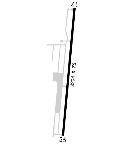
  • Runway Identifications
    Runway Identification: 17/35
    Length: 4204 ft
    Width: 75 ft
    Surface: ASPHALT-GOOD CONDITION
    Edge lights: Medium Intensity

    Treatment: NONE

     Runway: 17   Runway: 35
    Mag heading: 171°Mag heading: 351°
    Rwy Slope: .01% UpRwy Slope: -.01% Down
    Approach: Approach:
    Pattern: Left TrafficPattern: Left Traffic
    Markings: NONPRECISION INSTRUMENTMarkings: NONPRECISION INSTRUMENT
    Marking Condition: FAIRMarking Condition: FAIR
    Arresting Dev: Arresting Dev:
    Lat & Long: N4350.4  W11148.3Lat. & Long.: N4349.7  W11148.4
    Elev: 4858.1 ft. MSLElev: 4858.6 ft. MSL
    TCH: TCH: 40 ft. AGL
    Visual Glide Path: Visual Glide Path: 3.00 degrees
    Displaced Threshold: 302 feetDisplaced Threshold: No
    Touchdown Zone: YESTouchdown Zone: YES
    Touchdown Elev.: 4861.9 feetTouchdown Elev.: 4861.9 feet
    Visual Glide Slope: 4-BOX VASI ON RIGHT SIDE OF RUNWAYVisual Glide Slope: 4-BOX VASI ON LEFT SIDE OF RUNWAY
    RVR Equipment: RVR Equipment:
    RVV Equipment: NORVV Equipment: NO
    Approach Lights: Approach Lights:
    REIL: NOREIL: YES
    Centerline Lights: NOCenterline Lights: NO
    Touchdown lights: NOTouchdown lights: NO
    Runway Category: Runway with a Visual ApproachRunway Category: Runway with a Non-precision Approach having visibility minimums greater than 3/4 mile
    Declared Distances: TORA:4200' TODA:4200' ASDA:4200' LDA:3900'Declared Distances: TORA:4200' TODA:4200' ASDA:3900' LDA:3900'
    Obstructions: TREESObstructions: TREE
    Marked: NOT Marked/LightedMarked: NOT Marked/Lighted
    Clearance slope: 9:1; RWY 17 APCH SLOPE 26:1 TO DSPLCD THLD.Clearance slope: 10:1
    Obstruction height: 30 feet AGLObstruction height: 50 feet AGL
    Dist. from runway: 470 feetDist. from runway: 725 feet
    Centerline offset: 150 left of centerlineCenterline offset: 150 feet left of centerline
    Comments: +20 TO 50 FT TREES AT 160 FT; 150 FT LEFT & RIGHT.Comments:
    C:2/P: