Current Weather/Notams (Metars, TAFs, Notams, NWS Forecast, PIREPS, and nearby weather)
Customs Information Send updates to Support@FltPlan.com
Customs Not Available
Database effective 05/16/2024
Airport Diagram might not be current. Facility Name: RAWLINS MUNI/HARVEY FLD City Name: RAWLINS County: CARBON State abbrev: WY State Name: WYOMING Ownership: PUBLICLY OWNED Use: OPEN TO THE PUBLIC Owner's Name: RAWLINS CARBON CO ARPT BOARD Address: P.O. BOX 1363 RAWLINS, WY 82301 Owner's Phone: 307-324-2361 Manager's Name: MIKE GRUETZMACHER Address: 1300 AIRPORT ROAD RAWLINS, WY 82301 Phone: 307-324-2361 FAA Region: NORTHWEST MOUNTAIN FAA Field Office: DEN
Runway Identifications Help
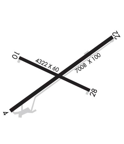
Runway Identification: 04/22 Length: 7008 ftWidth: 100 ftSurface: ASPHALT-GOOD CONDITIONEdge lights: Medium Intensity Treatment: GROOVED Runway: 04 Runway: 22 Mag heading: 44° Mag heading: 224° Rwy Slope: 1.03% Up Rwy Slope: -1.03% Down Approach: Approach: Pattern: Right Traffic Pattern: Left Traffic Markings: NONPRECISION INSTRUMENT Markings: NONPRECISION INSTRUMENT Marking Condition: GOOD Marking Condition: GOOD Arresting Dev: Arresting Dev: Lat & Long: N4148.0 W10712.6 Lat. & Long.: N4148.7 W10711.4 Elev: 6744.4 ft. MSL Elev: 6816.6 ft. MSL TCH: 44 ft. AGL TCH: 44 ft. AGL Visual Glide Path: 3.00 degrees Visual Glide Path: 3.00 degrees Displaced Threshold: No Displaced Threshold: No Touchdown Zone: YES Touchdown Zone: YES Touchdown Elev.: 6759.0 feet Touchdown Elev.: 6816.7 feet Visual Glide Slope: 4-Light PAPI on LEFT side of Runway Visual Glide Slope: 4-Light PAPI on LEFT side of Runway RVR Equipment: RVR Equipment: RVV Equipment: NO RVV Equipment: NO Approach Lights: Approach Lights: REIL: NO REIL: YES Centerline Lights: NO Centerline Lights: NO Touchdown lights: NO Touchdown lights: NO Runway Category: Runway with a Visual Approach Runway Category: Runway with a Non-precision Approach having visibility minimums greater than 3/4 mile Declared Distances: Declared Distances: Obstructions: TANK Obstructions: Marked: NOT Marked/Lighted Marked: Clearance slope: 19:1 Clearance slope: 50:1 Obstruction height: 29 feet AGL Obstruction height: Dist. from runway: 756 feet Dist. from runway: Centerline offset: 195 left of centerline Centerline offset: Comments: Comments:
Runway Identification: 11/29 Length: 4322 ftWidth: 60 ftSurface: ASPHALT-GOOD CONDITIONEdge lights: Medium Intensity Treatment: NONE Runway: 11 Runway: 29 Mag heading: 105° Mag heading: 285° Rwy Slope: -.68% Down Rwy Slope: .68% Up Approach: Approach: Pattern: Left Traffic Pattern: Right Traffic Markings: BASIC Markings: BASIC Marking Condition: GOOD Marking Condition: GOOD Arresting Dev: Arresting Dev: Lat & Long: N4148.5 W10712.5 Lat. & Long.: N4148.2 W10711.6 Elev: 6776.4 ft. MSL Elev: 6747.2 ft. MSL TCH: TCH: Visual Glide Path: Visual Glide Path: Displaced Threshold: No Displaced Threshold: No Touchdown Zone: YES Touchdown Zone: YES Touchdown Elev.: 6776.4 feet Touchdown Elev.: 6768.9 feet Visual Glide Slope: Visual Glide Slope: RVR Equipment: RVR Equipment: RVV Equipment: NO RVV Equipment: NO Approach Lights: Approach Lights: REIL: NO REIL: YES Centerline Lights: NO Centerline Lights: NO Touchdown lights: NO Touchdown lights: NO Runway Category: Runway with a Visual Approach Runway Category: Runway with a Visual Approach Declared Distances: Declared Distances: