Current Weather/Notams (Metars, TAFs, Notams, NWS Forecast, PIREPS, and nearby weather)
Customs Information Send updates to Support@FltPlan.com
Customs Not Available
Database effective 05/16/2024
Airport Diagram might not be current.
|
| Facility Name: | ROCKY MOUNT/WILSON RGNL |
| City Name: | ROCKY MOUNT |
| County: | NASH |
| State abbrev: | NC |
| State Name: | NORTH CAROLINA |
| | |
| Ownership: | PUBLICLY OWNED |
| Use: | OPEN TO THE PUBLIC |
| Owner's Name: | ROCKY MOUNT-WILSON ARPT AUTH |
| Address: | 7265 AIR TERMINAL DR |
| | ELM CITY, NC 27822 |
| Owner's Phone: | 252-446-7057 |
| | |
| Manager's Name: | JARRETT MOSS |
| Address: | 7265 AIR TERMINAL DR |
| | ELM CITY, NC 27822 |
| Phone: | 252-446-7057; ALT PHONE NUMBER: 252-469-8817. |
| | |
| FAA Region: | SOUTHERN |
| FAA Field Office: | MEM |
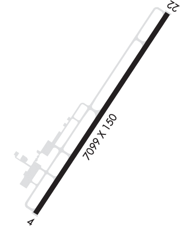
Runway Identifications
Runway Identification: 04/22Length: 7099 ft
Width: 150 ft
Surface: ASPHALT
Edge lights: High IntensityTreatment: GROOVED
Weight: PCN 40 /F/B/X/T
| | Runway: 04 | | Runway: 22 |
| Mag heading: | 42° | Mag heading: | 222° |
| Rwy Slope: | -.10% Down | Rwy Slope: | .10% Up |
| Approach: | ILS | Approach: | |
| Pattern: | Left Traffic | Pattern: | Left Traffic |
| Markings: | PRECISION INSTRUMENT | Markings: | PRECISION INSTRUMENT |
| Marking Condition: | GOOD | Marking Condition: | GOOD |
| Arresting Dev: | | Arresting Dev: | |
| Lat & Long: | N3550.9 W07753.9 | Lat. & Long.: | N3551.9 W07753.1 |
| Elev: | 157.7 ft. MSL | Elev: | 150.3 ft. MSL |
| TCH: | 41 ft. AGL | TCH: | 42 ft. AGL |
| Visual Glide Path: | 3.00 degrees | Visual Glide Path: | 3.00 degrees |
| Displaced Threshold: | No | Displaced Threshold: | No |
| Touchdown Zone: | YES | Touchdown Zone: | YES |
| Touchdown Elev.: | 157.7 feet | Touchdown Elev.: | 151.9 feet |
| Visual Glide Slope: | 4-Light PAPI on LEFT side of Runway | Visual Glide Slope: | 4-Light PAPI on LEFT side of Runway |
| RVR Equipment: | | RVR Equipment: | |
| RVV Equipment: | NO | RVV Equipment: | NO |
| Approach Lights: | MALSR - 1,400 foot medium intensity approach lighting system with runway alignment indicator lights | Approach Lights: | |
| REIL: | NO | REIL: | YES |
| Centerline Lights: | NO | Centerline Lights: | NO |
| Touchdown lights: | NO | Touchdown lights: | NO |
| Runway Category: | Precision Instrument Runway | Runway Category: | Runway with a Non-precision Approach having visibility minimums greater than 3/4 mile |
| Declared Distances: | TORA:7100' TODA:7100' ASDA:7100' LDA:7100' | Declared Distances: | TORA:7100' TODA:7100' ASDA:6900' LDA:6900' |
| Obstructions: | | Obstructions: | TREES |
| Marked: | | Marked: | NOT Marked/Lighted |
| Clearance slope: | 50:1 | Clearance slope: | 34:1 |
| Obstruction height: | | Obstruction height: | 56 feet AGL |
| Dist. from runway: | | Dist. from runway: | 2100 feet |
| Centerline offset: | | Centerline offset: | |
| Comments: | | Comments: | |

