Current Weather/Notams (Metars, TAFs, Notams, NWS Forecast, PIREPS, and nearby weather)
Customs Information Send updates to Support@FltPlan.com
Customs Not Available
Database effective 04/18/2024
Airport Diagram might not be current. Facility Name: TULSA RIVERSIDE City Name: TULSA County: TULSA State abbrev: OK State Name: OKLAHOMA Ownership: PUBLICLY OWNED Use: OPEN TO THE PUBLIC Owner's Name: CITY OF TULSA Address: TULSA ARPT IMPROVEMENT TRUST BOX 581838 TULSA, OK 74158 Owner's Phone: 918-838-5000 Manager's Name: AUSTIN WHEELER Address: 8303 S. HANGAR RD. TULSA, OK 74132 Phone: 918-299-5886 FAA Region: SOUTHWEST FAA Field Office: AOK
Runway Identifications Help
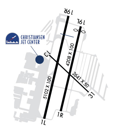
Runway Identification: 01L/19R Length: 5102 ftWidth: 100 ftSurface: ASPHALT-GOOD CONDITIONEdge lights: High Intensity Treatment: GROOVEDWeight: PCN 27 /F/B/X/T Runway: 01L Runway: 19R Mag heading: 10° Mag heading: 190° Rwy Slope: .32% Up Rwy Slope: -.32% Down Approach: ILS Approach: Pattern: Left Traffic Pattern: Right Traffic Markings: PRECISION INSTRUMENT Markings: NONPRECISION INSTRUMENT Marking Condition: FAIR Marking Condition: FAIR Arresting Dev: Arresting Dev: Lat & Long: N3602.0 W09559.3 Lat. & Long.: N3602.8 W09559.0 Elev: 621.5 ft. MSL Elev: 637.9 ft. MSL TCH: 48 ft. AGL TCH: 43 ft. AGL Visual Glide Path: 3.00 degrees Visual Glide Path: 3.20 degrees Displaced Threshold: No Displaced Threshold: No Touchdown Zone: YES Touchdown Zone: YES Touchdown Elev.: 625.8 feet Touchdown Elev.: 637.9 feet Visual Glide Slope: 4-Light PAPI on LEFT side of Runway Visual Glide Slope: 4-Light PAPI on LEFT side of Runway RVR Equipment: RVR Equipment: RVV Equipment: NO RVV Equipment: NO Approach Lights: Approach Lights: REIL: YES REIL: YES Centerline Lights: NO Centerline Lights: NO Touchdown lights: NO Touchdown lights: NO Runway Category: Precision Instrument Runway Runway Category: Runway with a Non-precision Approach having visibility minimums greater than 3/4 mile Declared Distances: TORA:5102' TODA:5102' ASDA:5102' LDA:5102' Declared Distances: TORA:5102' TODA:5102' ASDA:5102' LDA:5102' Obstructions: TREE Obstructions: TREES Marked: NOT Marked/Lighted Marked: NOT Marked/Lighted Clearance slope: 37:1 Clearance slope: 26:1 Obstruction height: 35 feet AGL Obstruction height: 33 feet AGL Dist. from runway: 1500 feet Dist. from runway: 1060 feet Centerline offset: 78 left of centerline Centerline offset: 130 feet left of centerline Comments: Comments:
Runway Identification: 01R/19L Length: 4208 ftWidth: 100 ftSurface: ASPHALT-GOOD CONDITIONEdge lights: Medium Intensity Treatment: NONE Runway: 01R Runway: 19L Mag heading: 10° Mag heading: 190° Rwy Slope: .26% Up Rwy Slope: -.26% Down Approach: Approach: Pattern: Right Traffic Pattern: Left Traffic Markings: BASIC Markings: BASIC Marking Condition: GOOD Marking Condition: GOOD Arresting Dev: Arresting Dev: Lat & Long: N3602.0 W09559.1 Lat. & Long.: N3602.7 W09558.9 Elev: 619.0 ft. MSL Elev: 630.0 ft. MSL TCH: 40 ft. AGL TCH: 40 ft. AGL Visual Glide Path: 2.83 degrees Visual Glide Path: 2.83 degrees Displaced Threshold: No Displaced Threshold: 142 feet Touchdown Zone: YES Touchdown Zone: YES Touchdown Elev.: 623.7 feet Touchdown Elev.: 630.0 feet Visual Glide Slope: 4-Light PAPI on LEFT side of Runway Visual Glide Slope: 4-Light PAPI on LEFT side of Runway RVR Equipment: RVR Equipment: RVV Equipment: NO RVV Equipment: NO Approach Lights: Approach Lights: REIL: NO REIL: NO Centerline Lights: NO Centerline Lights: NO Touchdown lights: NO Touchdown lights: NO Runway Category: Runway with a Visual Approach Runway Category: Runway with a Visual Approach Declared Distances: TORA:4208' TODA:4208' ASDA:4208' LDA:4208' Declared Distances: TORA:4208' TODA:4208' ASDA:4208' LDA:4066' Obstructions: Obstructions: ROAD Marked: Marked: NOT Marked/Lighted Clearance slope: 20:1 Clearance slope: Obstruction height: Obstruction height: 8 feet AGL Dist. from runway: Dist. from runway: 200 feet Centerline offset: Centerline offset: Comments: Comments: 8 FT ROAD 200 FT FM RWY THR, BOTH SIDES.
Runway Identification: 13/31 Length: 2641 ftWidth: 50 ftSurface: ASPHALT-FAIR CONDITIONEdge lights: Medium Intensity Treatment: NONE Runway: 13 Runway: 31 Mag heading: 130° Mag heading: 310° Rwy Slope: -.35% Down Rwy Slope: .35% Up Approach: Approach: Pattern: Left Traffic Pattern: Right Traffic Markings: BASIC Markings: BASIC Marking Condition: GOOD Marking Condition: GOOD Arresting Dev: Arresting Dev: Lat & Long: N3602.5 W09559.2 Lat. & Long.: N3602.2 W09558.8 Elev: 623.8 ft. MSL Elev: 614.6 ft. MSL TCH: TCH: Visual Glide Path: Visual Glide Path: Displaced Threshold: No Displaced Threshold: No Touchdown Zone: YES Touchdown Zone: YES Touchdown Elev.: 625.8 feet Touchdown Elev.: 625.8 feet Visual Glide Slope: Visual Glide Slope: RVR Equipment: RVR Equipment: RVV Equipment: NO RVV Equipment: NO Approach Lights: Approach Lights: REIL: NO REIL: NO Centerline Lights: NO Centerline Lights: NO Touchdown lights: NO Touchdown lights: NO Runway Category: Runway with a Visual Approach Runway Category: Runway with a Visual Approach Declared Distances: TORA:2641' TODA:2641' ASDA:2641' LDA:2641' Declared Distances: TORA:2641' TODA:2641' ASDA:2641' LDA:2641'