Click here for more info on on SMS!

KRVN

HAWKINS COUNTY
ROGERSVILLE
TN
Time Zone: Eastern
Lat: N 3627.5
Long: W 08253.1
Elev: 1255
Var: +07
Longest Runway: 3504
CTAF: 122.8

FBO & Flight Services info for KRVN

FBOs: Update your Fuel Prices

FINLEY AVIATIONPh: 423-345-0219 Fax: 423-345-0221 Freq: 122.8
Service
Jet
100LL
SAF
MoGas
Fuel Avail: ~~Availability of Services Is Unknown
Full        Last Update: 04/26/2024 00:15:41

Self        
If you are an FBO, call 1-203-262-1700 to update your info or email: FltPlan.Advertising@garmin.com
Advertise your FBO on FltPlan.com

Runway & Approach Info for KRVN
Rwy
Length
Land Dist**
Approach*
  Rwy
Length
Land Dist**
Approach*
07
3504x75  3504'          
 
  
25
  3504x75  3504'          
 
 * only ILS, LOC, LDA, and SDF approaches to a specific runway are shown
** For any Declared Landing Distance Available, please see A/FD or Approach plates
Runway Weight Capability (lbs.) Help
Runway IDSingle WheelDouble WheelDouble Tandem WheelDual Double Wheel
07/2525,000N/AN/AN/A
These numbers are Advisory and are not limits.   The Airport Manager should have more accurate Weight Limits
Approach Charts
Approaches    
Current Weather/Notams
Customs Information Send updates to Support@FltPlan.com
Customs Not Available
Database effective 05/16/2024
Airport Diagram of KRVN
Airport Diagram might not be current.

Facility Name: HAWKINS COUNTY
City Name: ROGERSVILLE
County: HAWKINS
State abbrev: TN
State Name: TENNESSEE
   
Ownership: PUBLICLY OWNED
Use: OPEN TO THE PUBLIC
Owner's Name: HAWKINS COUNTY
Address: COURTHOUSE, 150 WASHINGTON ST
 ROGERSVILLE, TN 37857
Owner's Phone: 423-272-7359
  
Manager's Name: MARK FINLEY
Address: 675 MAIN ST
 SURGOINSVILLE, TN 37873
Phone: 423-345-0219
   
FAA Region: SOUTHERN
FAA Field Office: MEM


Sunrise / Sunset times for HAWKINS COUNTY

DateSunriseSunset
04/25/24 Thursday6:4420:15
04/26/24 Friday6:4320:16
04/27/24 Saturday6:4220:17
04/28/24 Sunday6:4120:18
04/29/24 Monday6:4020:19
04/30/24 Tuesday6:3820:19
05/01/24 Wednesday6:3720:20
05/02/24 Thursday6:3620:21
05/03/24 Friday6:3520:22
05/04/24 Saturday6:3420:23
05/05/24 Sunday6:3320:24
05/06/24 Monday6:3220:25
05/07/24 Tuesday6:3120:25
05/08/24 Wednesday6:3020:26

Airport Facilities

Airport Attendance Schedule7 Days A Week 0800-1700; UNATNDD MAJOR HOL.
Airport Status OPERATIONAL (This Status can change at any time - please check NOTAMS)
Airport Lighting ScheduleACTVT RWY 7 & 25 REILS; PAPIS 7 & 25; MIRLS RWY 7/25 - CTAF.
Airport Storage AvailableTie Downs, Hanger
Extra Services AvailableFlight Instruction
Wind IndicatorYES - (lighted)
Control TowerNO
CTAF Frequency122.800
Unicom Frequency122.800
Rotating Beacon ColorWG
Segmented CircleYES
Landing FeeNO

Airport Inspection Data

Airport InspectedSTATE - performed by STATE AERONAUTICAL PERSONNEL
Inspection Date03/11/2024

Airport Services

Type of Fuel AvailableGrade 100LL; -10H24 SELF SVC FUEL AVBL.
Airframe Repair ServiceMAJOR
Power Plant Repair ServiceMAJOR

Geographic Data

LatitudeN3627.5
LongitudeW08253.1 (ESTIMATED)
Arpt Elevation1254ft (SURVEYED)
Magnetic Variation07W
6 miles NEof ROGERSVILLE
Traffic Pattern Altitude
Sectional ChartCINCINNATI

Aircraft Data

Operations (Reported)YearlyAvg. Daily
General Aviation Transient 4281
General Aviation Local 5562
Air Taxi 120
Commerical 00
Commuter 00
Military 40
Aircraft based on Field
General Aviation Singles 20
General Aviation Multi 0
Jet Aircraft 0
General Aviation Helicopters 0
Military Aircraft 0
Gliders 0
Ultralights 0

FAA Services

FSS on field NO
FSS tie-in NASHVILLE
FSS Phone 1-800-WX-BRIEF
Who issues Notams BNA
Notam D service at airport YES
ARTCC Name ATLANTA

Federal Status

Airport Certification
Aircraft Rescue & Firefighting IndexNone
Airport of EntryNo
Custom Landing RightsNo
Joint Civil/MilitaryNo
Military Landing rightsYES

Federal Agreements

NATIONAL PLAN OF INTEGRATED AIRPORT SYSTEMS (NPIAS)
GRANT AGREEMENTS UNDER FAAP/ADAP/AIP
ASSURANCES PURSUANT TO TITLE VI, CIVIL RIGHTS ACT OF 1964

Remarks

DEER ON & INVOF ARPT.
FOR CD CTC ATLANTA ARTCC AT 770-210-7692.
RWY 07 3118 FT MT RIDGE SE OF ARPT WI 9 NM.
Airport Communications & Frequencies:
CTAF Frequency:
122.800
Unicom Frequency:
122.800
Remarks
  • APCH/DEP SVC PRVDD BY ATLANTA ARTCC ON FREQS 127.85/269.3 (GLADE SPRINGS RCAG) WHEN TRI CITY APCH CTL CLSD.
  • TRI CITY Primary Approach Frequencies:  
    128.05
    317.5
    TRI CITY Primary Departure Frequencies:  
    128.05
    317.5
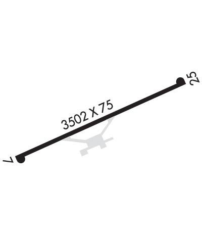
    Runway Identifications
    Runway Identification: 07/25
    Length: 3504 ft
    Width: 75 ft
    Surface: ASPHALT-FAIR CONDITION
    Edge lights: Medium Intensity

    Treatment: NONE

     Runway: 07   Runway: 25
    Mag heading: 71°Mag heading: 251°
    Rwy Slope: -.70% DownRwy Slope: .70% Up
    Approach: Approach:
    Pattern: Left TrafficPattern: Left Traffic
    Markings: NONPRECISION INSTRUMENTMarkings: NONPRECISION INSTRUMENT
    Marking Condition: FAIRMarking Condition: FAIR
    Arresting Dev: Arresting Dev:
    Lat & Long: N3627.3  W08253.4Lat. & Long.: N3627.6  W08252.8
    Elev: 1254.5 ft. MSLElev: 1229.8 ft. MSL
    TCH: 25 ft. AGLTCH: 29 ft. AGL
    Visual Glide Path: 3.00 degreesVisual Glide Path: 3.00 degrees
    Displaced Threshold: NoDisplaced Threshold: No
    Touchdown Zone: YESTouchdown Zone: YES
    Touchdown Elev.: 1254.6 feetTouchdown Elev.: 1253.7 feet
    Visual Glide Slope: 2-Light PAPI on LEFT side of RunwayVisual Glide Slope: 2-Light PAPI on LEFT side of Runway
    RVR Equipment: RVR Equipment:
    RVV Equipment: NORVV Equipment: NO
    Approach Lights: Approach Lights:
    REIL: YESREIL: YES
    Centerline Lights: NOCenterline Lights: NO
    Touchdown lights: NOTouchdown lights: NO
    Runway Category: Runway with a Non-precision ApproachRunway Category: Runway with a Non-precision Approach
    Declared Distances: Declared Distances:
    Obstructions: TREESObstructions: TREES
    Marked: NOT Marked/LightedMarked: NOT Marked/Lighted
    Clearance slope: 18:1Clearance slope: 11:1
    Obstruction height: 24 feet AGLObstruction height: 72 feet AGL
    Dist. from runway: 637 feetDist. from runway: 1025 feet
    Centerline offset: 144 right of centerlineCenterline offset: 225 feet right of centerline
    Comments: Comments:
    C:/P: