
| ||||||||||||||||||||||||||||||||||||||||||||
| ||||||||||||||||||||||||||||||||||||||||||||
| ||||||||||||||||||||||||||||||||||||||||||||
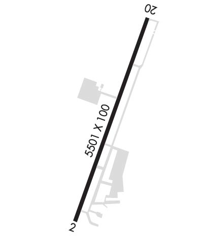
| Rwy | Rwy | |||||||
| 5501x100 | 5375' | 5501x100 | 5501' | 109.95 - 201° | ||||
| Runway ID | Single Wheel | Double Wheel | Double Tandem Wheel | Dual Double Wheel |
| 02/20 | 45,000 | 55,000 | N/A | N/A |
| These numbers are Advisory and are not limits. The Airport Manager should have more accurate Weight Limits | ||||
 Airport Diagram might not be current. | |
| Facility Name: | MID-CAROLINA RGNL |
| City Name: | SALISBURY |
| County: | ROWAN |
| State abbrev: | NC |
| State Name: | NORTH CAROLINA |
| Ownership: | PUBLICLY OWNED |
| Use: | OPEN TO THE PUBLIC |
| Owner's Name: | ROWAN COUNTY |
| Address: | 130 W. INNES ST |
| SALISBURY, NC 28144 | |
| Owner's Phone: | 704-216-8100 |
| Manager's Name: | VALERIE STEELE |
| Address: | 3670 AIRPORT LOOP |
| SALISBURY, NC 28147-8921 | |
| Phone: | 704-216-7753 |
| FAA Region: | SOUTHERN |
| FAA Field Office: | MEM |
| Date | Sunrise | Sunset |
|---|---|---|
| 04/16/24 Tuesday | 6:47 | 19:57 |
| 04/17/24 Wednesday | 6:46 | 19:58 |
| 04/18/24 Thursday | 6:45 | 19:58 |
| 04/19/24 Friday | 6:43 | 19:59 |
| 04/20/24 Saturday | 6:42 | 20:00 |
| 04/21/24 Sunday | 6:41 | 20:01 |
| 04/22/24 Monday | 6:40 | 20:02 |
| 04/23/24 Tuesday | 6:38 | 20:03 |
| 04/24/24 Wednesday | 6:37 | 20:03 |
| 04/25/24 Thursday | 6:36 | 20:04 |
| 04/26/24 Friday | 6:35 | 20:05 |
| 04/27/24 Saturday | 6:34 | 20:06 |
| 04/28/24 Sunday | 6:33 | 20:07 |
| 04/29/24 Monday | 6:32 | 20:08 |
| Airport Attendance Schedule | 7 Days A Week 0800-2000; UNATNDD THANKSGIVING AND CHRISTMAS DAY. TO SKED AFT HRS OR HOLIDAY SVC CALL 980-892-2840. |
| Airport Status | OPERATIONAL (This Status can change at any time - please check NOTAMS) |
| Airport Lighting Schedule | ACTVT MALSR RWY 20; REIL RWY 02 & 20; PAPI RWY 02 & 20; MIRL RWY 02/20 - CTAF. |
| Airport Storage Available | Tie Downs, Hanger |
| Extra Services Available | Air Freight, Avionics, Charter, Flight Instruction, Parachute Jumping, Aircraft Rental |
| Wind Indicator | YES - (lighted) |
| Control Tower | NO |
| CTAF Frequency | 122.725 |
| Unicom Frequency | 122.725 |
| Rotating Beacon Color | WG |
| Segmented Circle | YES |
| Landing Fee | NO |
| Airport Inspected | STATE - performed by STATE AERONAUTICAL PERSONNEL |
| Inspection Date | 09/02/2023 |
| Type of Fuel Available | Grade 100LL, JET A-1 (icing inhibitor, freeze point -50C); -A1MIL FUEL A+ CTC KILLDEVIL OPS 24 HR PPR, C 984-661-6506/6507/6557.; -1024 SELF SERVICE AVBL FOR 100LL WITH CREDIT CARD. |
| Airframe Repair Service | MAJOR |
| Power Plant Repair Service | MAJOR |
| Latitude | N3538.8 |
| Longitude | W08031.2 (ESTIMATED) |
| Arpt Elevation | 772ft (SURVEYED) |
| Magnetic Variation | 06W |
| 3 miles SW | of SALISBURY |
| Traffic Pattern Altitude | |
| Sectional Chart | CHARLOTTE |
| Operations (Reported) | Yearly | Avg. Daily |
|---|---|---|
| General Aviation Transient | 25000 | 68 |
| General Aviation Local | 20000 | 55 |
| Air Taxi | 1000 | 3 |
| Commerical | 0 | 0 |
| Commuter | 0 | 0 |
| Military | 5000 | 14 |
| Aircraft based on Field | |
|---|---|
| General Aviation Singles | 73 |
| General Aviation Multi | 9 |
| Jet Aircraft | 3 |
| General Aviation Helicopters | 4 |
| Military Aircraft | 10 |
| Gliders | 0 |
| Ultralights | 0 |
| FSS on field | NO |
| FSS tie-in | RALEIGH |
| FSS Phone | 1-800-WX-BRIEF |
| Who issues Notams | RUQ |
| Notam D service at airport | YES |
| ARTCC Name | ATLANTA |
| Airport Certification | |
| Aircraft Rescue & Firefighting Index | None |
| Airport of Entry | No |
| Custom Landing Rights | No |
| Joint Civil/Military | No |
| Military Landing rights | YES |
| NATIONAL PLAN OF INTEGRATED AIRPORT SYSTEMS (NPIAS) |
| GRANT AGREEMENTS UNDER FAAP/ADAP/AIP |
| ASSURANCES PURSUANT TO TITLE VI, CIVIL RIGHTS ACT OF 1964 |
| MAIN TRML APRON GRASS AREA ADJ TO FUEL PUMPS CLSD TO HELS. |
| BE ALERT FOR MIL ROTOR WING TFC. RNG RAMP LCTD W OF RWY. FRQ NGT OPS. |
| CTC KILLDEVIL OPS 10 MIN PRIOR TO LDG. RNG OPS FREQ - 40.700, 126.100, 293.000. |
| FOR CD CTC CHARLOTTE APCH AT 704-359-0241. |
| ADDNL OBSTNS FOR RWY 02; 20 FT BLDG 1100 FT FM THR 100 FT R OF CNTRLN. |
| 24 HR SVC BY REQ. FOR AFT HRS SVC CALL 980-892-2840. |
| TRANSIT MIL FUEL. |
| SKY DIVING OPS OVR ARPT; DO NOT OVERFLY ARPT DRG SKY DIVING OPS. |
Airport Communications & Frequencies:
| ||||||||||||||||
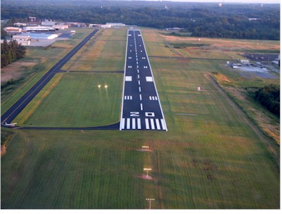
| Runway: 02 | Runway: 20 | ||
| Mag heading: | 22° | Mag heading: | 202° |
| Rwy Slope: | -.06% Down | Rwy Slope: | .06% Up |
| Approach: | Approach: | ILS | |
| Pattern: | Left Traffic | Pattern: | Left Traffic |
| Markings: | NONPRECISION INSTRUMENT | Markings: | PRECISION INSTRUMENT |
| Marking Condition: | GOOD | Marking Condition: | GOOD |
| Arresting Dev: | Arresting Dev: | ||
| Lat & Long: | N3538.3 W08031.4 | Lat. & Long.: | N3539.2 W08031.1 |
| Elev: | 769.1 ft. MSL | Elev: | 765.6 ft. MSL |
| TCH: | 34 ft. AGL | TCH: | 47 ft. AGL |
| Visual Glide Path: | 3.00 degrees | Visual Glide Path: | 3.00 degrees |
| Displaced Threshold: | 126 feet | Displaced Threshold: | No |
| Touchdown Zone: | YES | Touchdown Zone: | YES |
| Touchdown Elev.: | 772.3 feet | Touchdown Elev.: | 772.0 feet |
| Visual Glide Slope: | 2-Light PAPI on LEFT side of Runway | Visual Glide Slope: | 2-Light PAPI on LEFT side of Runway |
| RVR Equipment: | RVR Equipment: | ||
| RVV Equipment: | NO | RVV Equipment: | NO |
| Approach Lights: | Approach Lights: | MALSR - 1,400 foot medium intensity approach lighting system with runway alignment indicator lights | |
| REIL: | YES | REIL: | YES |
| Centerline Lights: | NO | Centerline Lights: | NO |
| Touchdown lights: | NO | Touchdown lights: | NO |
| Runway Category: | Runway with a Non-precision Approach having visibility minimums greater than 3/4 mile | Runway Category: | Precision Instrument Runway |
| Declared Distances: | Declared Distances: | ||
| Obstructions: | TREES | Obstructions: | TREES |
| Marked: | NOT Marked/Lighted | Marked: | NOT Marked/Lighted |
| Clearance slope: | 17:1; APCH RATIO 22:1 AT DSPLCD DUE TO 41 FT TREES 1123 FT FM THR OFFSET 418 LEFT OF CNTRLN. | Clearance slope: | 1:1 |
| Obstruction height: | 35 feet AGL | Obstruction height: | 23 feet AGL |
| Dist. from runway: | 814 feet | Dist. from runway: | 231 feet |
| Centerline offset: | 356 left of centerline | Centerline offset: | 297 feet left of centerline |
| Comments: | Comments: | 15 FT TREES 0-200 FT FM THR OFFSET 325 FT LEFT OF CNTRLN. |